Terpeast
-
Posts
5,326 -
Joined
-
Last visited
Content Type
Profiles
Blogs
Forums
American Weather
Media Demo
Store
Gallery
Everything posted by Terpeast
-
Verbatim yep. Pummeled
-
33/7 should dip below freezing soon
-
Finally got home after daughters playdate and doing some last minute shopping. I’m so STOKED for all of us in this subforum. This isn’t going to be a piecemeal storm for smaller portions of this forum like last year or Jan 2022. Everyone is going to get snow, most warning level or above. Majority of us will hit MECS (8”+) criteria, something we have been waiting for so so long. A few lucky ones will receive over a foot. Let’s reel this baby in!
-
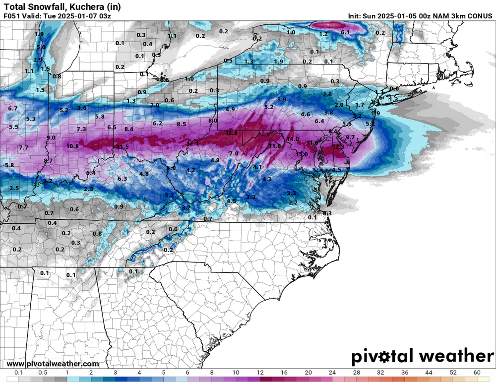
34/7 Final call (quick thoughts): Bumping up numbers for DC-annapolis-delmarva. 6-12” locally 15” somewhere ESE of DC. That’s along a 30-40 mile swath centered on i-66 + US 50. No longer worried about mixing imby. Mix line stops somewhere between EZF and dumfries, then retreats south as coastal takes over. 4-8” between south side of DC beltway and EZF, 2-4” mix south Along i-70 should still see 5-10”, then drop off to 3-6” along M/D line. Sorry if sloppy, am on mobile
-
Looks like it went south by two rows of counties. Something to keep in mind, yes
-
Busy morning with daughter’s playdate. I’ll try to sneak my final call before the 18z runs. I think DC metro + all suburbs will like it.
-
If it really dumps, DCA might lose the snow board again
-
LWX bumped up the top 10% potential accums. If 12z holds, I’ll bump up my forecast and make a final call
-
Euro great run! Now I suggest resting up tonight and tomorrow as much as you can, because we won’t be getting much sleep tomorrow night through Monday.
-
Now its only about 50 miles off from the other models. Which isn’t much.
-
That’s 12k. this is 3k (not done snowing yet)
-
Not so fast bro, I’ll see if these NAM and HRRR runs hold through tomorrow 12z then I’ll reassess for a final call tomorrow night
-
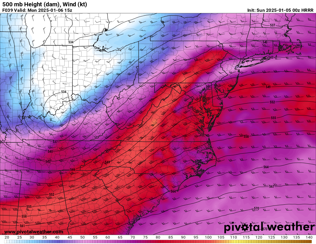
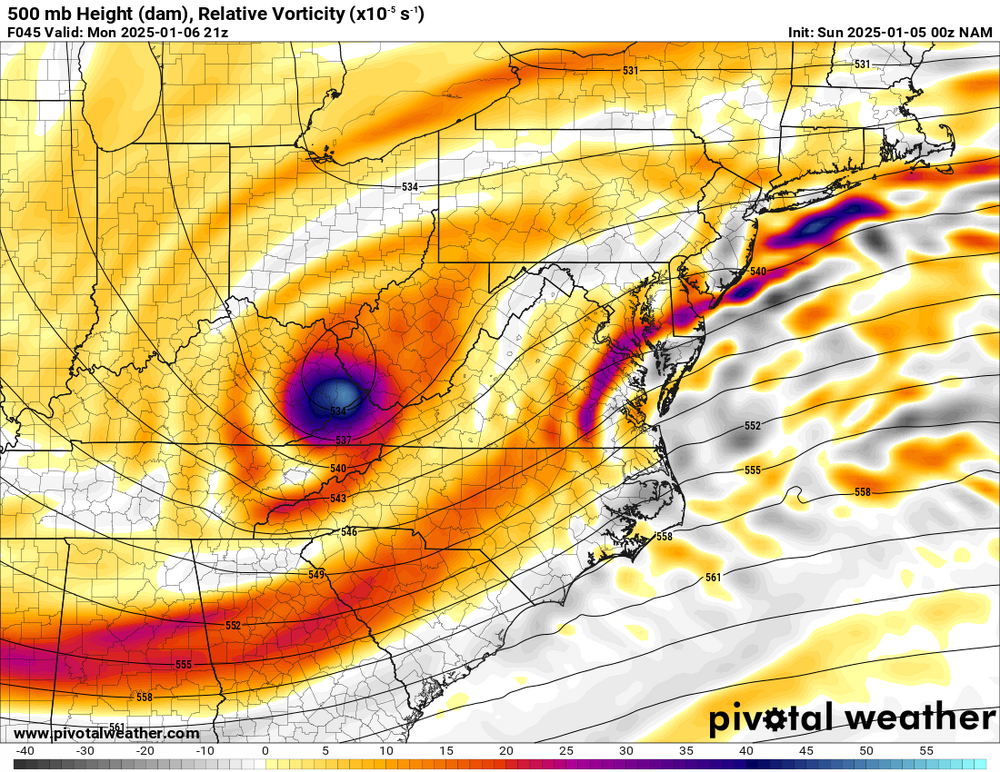
H5 low closes off again
-
Precip shield more robust for everyone here
-
Thermals do appear cooler this NAM run. Will check 3k too edit: 3k thermals also a touch cooler at hrs 30-32
-
Were they expecting to start with freezing rain and then later change over to snow?
-
Now this is where I see us mixing, but in the end it shouldn’t matter much because rates are so light then
-
Closed low at 500. If it passes over us, watch out

-
HRRR shows quite the thump. Hopefully its thermals are correct and I turn out to be too conservative DC south
-
First call: I’m in favor of the northern group of models and not really buying into the foot plus snows around EZF, nor am I buying the weird “dry slot” in the WAA portion of the storm. Even though confluence is very strong and we have a cold antecedent airmass, this is a very dynamic system with a powerful 70kt low level jet. We’ll see dual banding with 850 and 700 fgen, with the former along i-66 (give or take) and the latter between i-70 and the M/D line. Mix line likely to reach DC, and sleet/fzdz may even occur as far north as i-70 WHEN rates lighten up (heavier rates will be snow). Greatest uncertainty is whether a coastal gets going in time for us to get an extra few inches. In my first call, I say it will. My snowfall forecast (east of blue ridge): South of CHO - EZF - La Plata line: 1-3” heavy mix Delmarva South of Salisbury: 3-5” Delmarva North of Salisbury: 5-10”++ EZF north to I-66: 3-6” mix Between I-66 and I-70: 5-10” with some sleet/fzdz Between I-70 and M/D line: 6-12” all snow I reserve my right to make a final call when I see the need to make changes. P.S. Beltway DC metro? 4-7” with some mix
-
And there it is. Models are converging
-
Didn’t even get half an inch, and there is still some patchy snow otg. It’s cold. 27 now, wind chill 14
-
I’m thinking GFS is trying to find a compromise. This might be it
-
According to LWX WSW, it looks like they are banking on a warm nose up to and along i-66 and maybe a bit north of that. Still calling for 5-9” locally up to 12”
-
I expect that 18z and 0z runs tonight will start converging onto a final solution (more or less).