Terpeast
-
Posts
5,326 -
Joined
-
Last visited
Content Type
Profiles
Blogs
Forums
American Weather
Media Demo
Store
Gallery
Everything posted by Terpeast
-
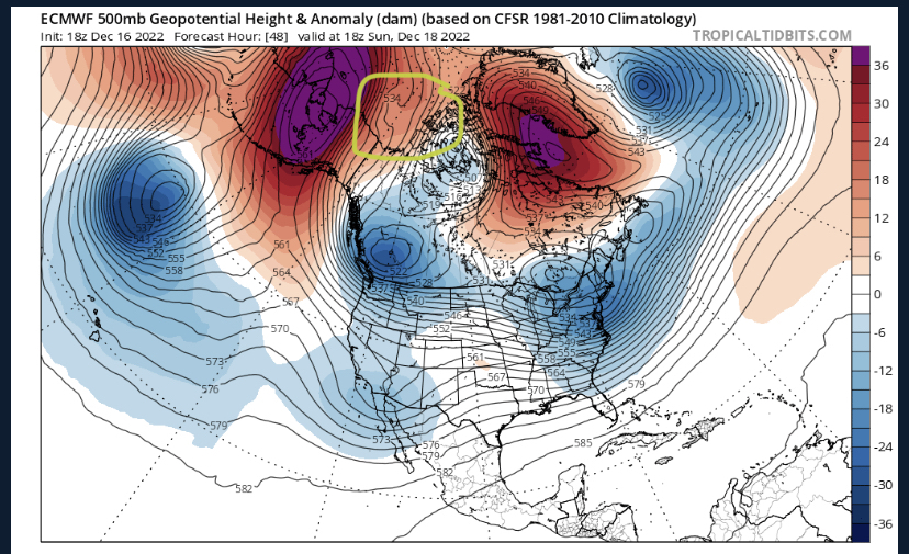
Feature to watch is the s/w riding over the alaska block (circled yellow) If it stays strong and sharp, then we get a good solution per gfs. If it flattens and shears out like the 12z euro, we lose the storm. Butterfly effect.
-
That was an out-to-sea scenario, and then it turned north at the last minute. I remember Doug Hill saying "okay, I'm a little suspicious, this seems to be moving north not east..." We're not going to do the reverse unless there's a redevelopment scenario.
-
Yeah, skewed mean is probably the best explanation. That's why we have to be careful "blending" models together.
-
Curious. If NBM is a "blend" of models, and most models are going cutter, how can this be?
-
Unless the GFS digs in and scores the coup of the century, this may be the best case scenario... cutter with redevelopment over CAD with a small thump to dry slot. I'll take it if it the models compromise to that scenario.
-
That has to be a shift of at least 1,000 miles
-
Maybe we're just used to losing storms modeled 7 days out so we're not that surprised.
-
The fact that WPC favors the Euro over GFS over the first 3 days of the model runs gives me pause. What if the Euro is correct on handling the ULL in W Canada for the first 72 hours from now.
-
Here’s how WPC is weighting models for their forecast blend: “The WPC fronts/pressures was primarily based on a 40% ECMWF/20% GFS/20% CMC/20% ECENS blend for Monday and Tuesday, and then the proportion of the ECENS and GEFS means were increased going through the remainder of the week to account for the increasing model uncertainty. Future forecast updates will provide additional clarity on the eventual East Coast storm evolution and potential impacts.” This was after the 0z suite. https://www.wpc.ncep.noaa.gov/discussions/hpcdiscussions.php?disc=pmdepd
-
Yeah, that is a key player in all this. Without that thing, or it behaves differently, the whole thing falls apart and we get a 2-4er, mix, or a total whiff. I don't think we get a cutter this time, though.
-
I said yesterday that if the models keep showing this look today, we can start to get excited. Well...
-
For those of us hoping for a KU (I'll admit, I'm one of them), we have to remember that there have been only two Decembers in the last 50 years that had double digit monthly snowfall amounts at DCA. At IAD, there has only been 5 double digit Decembers. Keep expectations accordingly. (advice goes for me, too)
-
I don’t have access to the latest eps, but I’d compare the h5 to gefs at 144
-
That first low robs the real storm of its energy, but I think that’s a phantom depiction. It won’t play out like that. As long as the 500mb setup is there, I like what I see for the EC from VA to new england
-
Bit of a weird run because it has 2 lows, one OTS first then another off OBX. Think it’s a bit of a hiccup but no real trend
-
Reminds me of Jan 1996 (I won’t dare say this is happening again) because that s/w “dived” south from Canada to south of TN before the beatdown. 7 days away, so not pinning anything on this.
-
My bad, that one isn’t the 12/23 storm. It’s what comes after.
-
Yeah, no big changes. Southern s/w better defined I think
-
Had to look it up. NBM is basically a blend of a bunch of models? How has it been performing?
-
Finished with 1.76” at Ashburn
-
That’s a wise approach. But that’s not how this forum rolls (even though we know better)
-
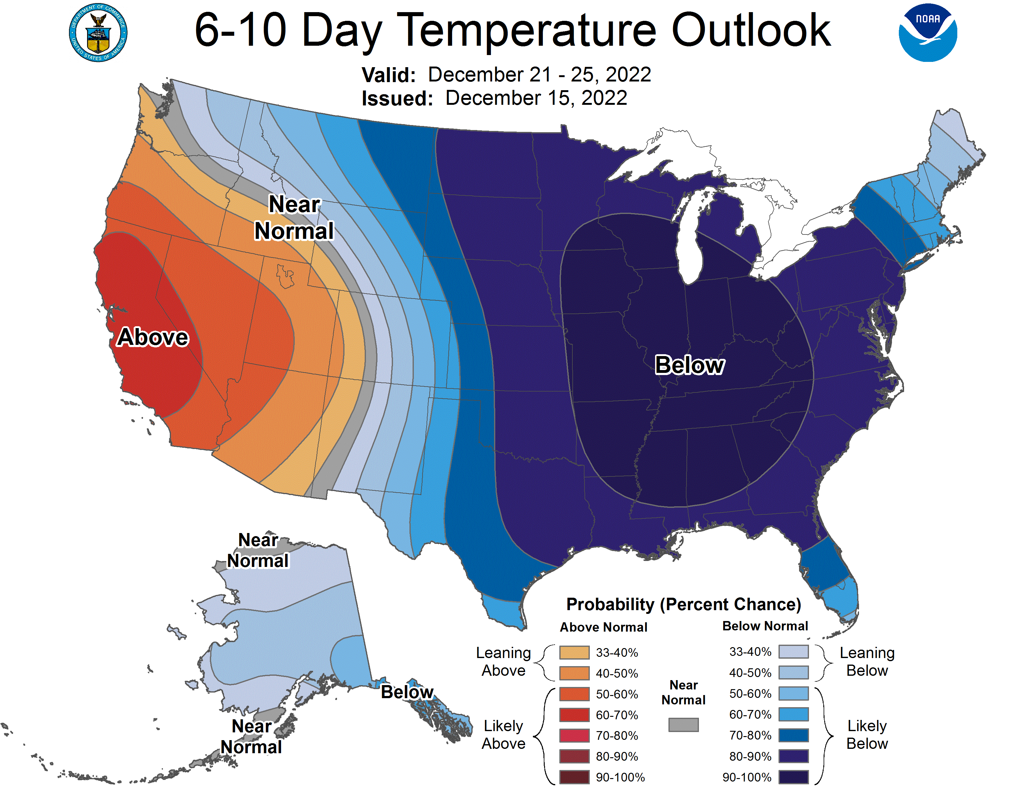
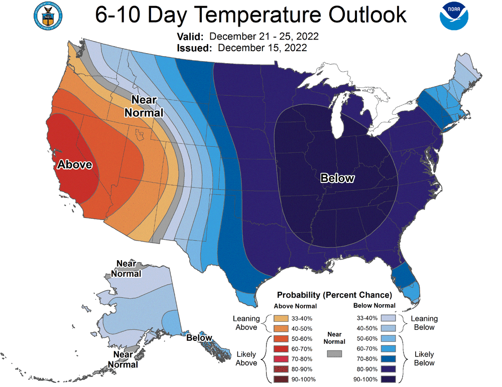
Kinda amazing to see the CPC put out a map like this.
-
Ok if models still show tomorrow what they’re showing today, then I think we are in game time.
-
Around this time tomorrow we get into the 7 day window for this one. How far ahead did the models sniff out this major dakotas blizzard and a mostly rain event here today?
-
About to wrap it up here at 1.6” 36F