Terpeast
-
Posts
5,326 -
Joined
-
Last visited
Content Type
Profiles
Blogs
Forums
American Weather
Media Demo
Store
Gallery
Everything posted by Terpeast
-
Just when you’re ready to move on, it pulls you back in with a bit of hopium
-
Yeah, if it’s trending that way, it’s not even worth a chase to Deep Creek
-
And Montreal could be next. btw @psuhoffman I agree with you, and wrt that CFS map I posted I was speaking in general terms, not that I expect it to verify. I hope, yes. But expect? No.
-
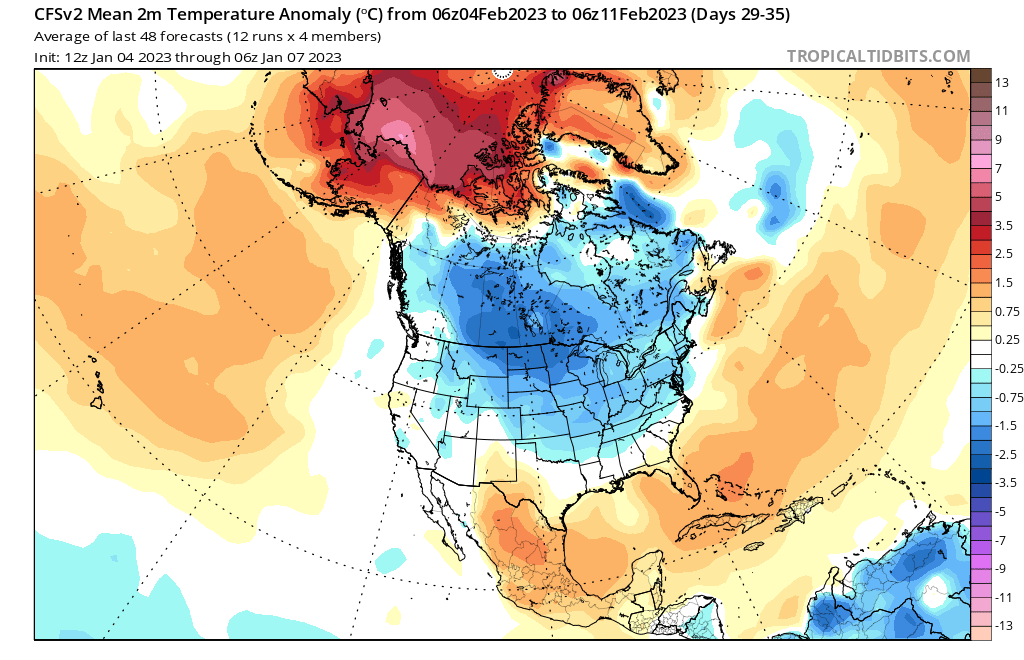
I know it’s the CFS and it’s a month away. But a map like this would work so much better for us.
-
When I look at this temp map, I don’t know how even a good track is going to help us. EDIT: it would be one thing if it was just slightly warm, like a couple degrees C AN. But +10C across the board?
-
Tbh since I moved here, it seemed qpf underperforms here almost every time
-
Your explanation was fine. I’m tipsy too, so I can’t go into more detail than we have already.
-
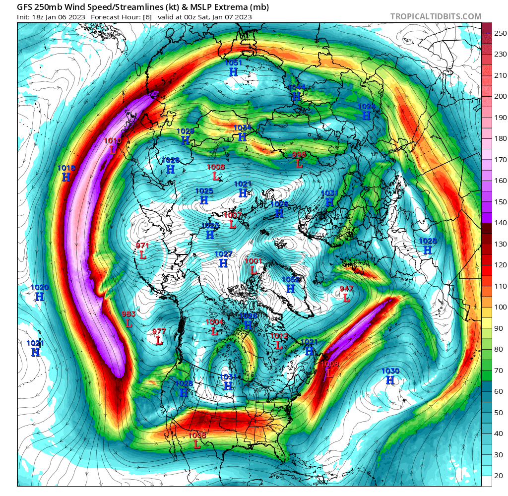
You could look at the 250 mb map and see where the strongest jet streams are. Right now we have a screaming pac jet and the airmasses follow that. Also note the trough over the west coast, and that trough also brings warm pacific air from SW of baja and basically floods the whole conus with it

-
We’re getting buried. Don’t worry. Enjoy the buzz.
-
LWX not quite sold yet. .SHORT TERM /SATURDAY NIGHT THROUGH SUNDAY NIGHT/... High pressure ridging aloft expected Saturday night. The next low pressure system will approach Sunday into Sunday night. Most late afternoon and evening model guidance show more of a wintry mix or snow scenario across parts of our region rather than mostly rain. There will still be rain over a large portion but somewhere in the region could get a light accumulation of snow. Icing does appear most likely at or above 2kft AGL across the Blue Ridge, Allegheny, and Potomac Highlands. Still expecting rather minor icing amounts at this juncture. Will continue to monitor future models and trends. Uncertainty remains high given the thermodynamic profiles. We`ll continue to monitor this system and refine our forecast over the next few days.
-
Good to know. I didn’t even know that there was a potential event yesterday though.
-
Hah, walked right into that one. I’ll know by Tuesday.
-
This range is in NAM’s wheelhouse now, no?
-
I'm starting to like the trends out of both NAM and GFS.
-
This is why I cut my grass extra short.
-
Not to get super technical about it, but take the winter season as 1/4 of the year, which is 365 days. That gives us 91.25 days to get snow. But using your 95% figure, we don’t get snow on 95% of those days. That leaves the remaining 5%, and we get roughly 4.6 snow days. Well, if I’m being honest, I’d take my 4.6 snow days and run laughing all the way to the bank.
-
Note very small shifts in the pacific, but the atlantic is totally different from run to run. It has no idea how to handle the atlantic.
-
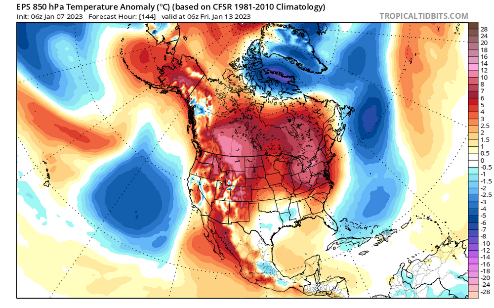
Nearly a 15 degree swing in 850 temps on the Euro compared to 12z yesterday. However this shakes out, we shouldn't expect them to converge onto a solution until Monday, maybe Sunday.
-
Looks like the Euro and GFS are about to switch places. We all know how that plays out in the end.
-
Yeah, if it starts to trend colder at least on the onset and it appears we get a front end thump, I'm staying put. But if it basically shows all rain east of the blue ridge, I'm chasing. Just gotta sell the wife on this...
-
By Tuesday-ish, I'll make a decision whether to chase this in Deep Creek/Canaan (and take my family & our sleds with me)... or stay home.
-
Has this actually been trending cooler each run?
-
Damn, that’s kinda heartbreaking. If it were me, I’d have a lot more angst about this too. My wife was just happy to see a brief squall pass through, and my little girl is not even 2 years old yet. For her, ignorance is bliss. I just gotta be careful not to talk too much about snow in our house.
-
Moving to Watertown or Montreal wouldn't have helped in this storm. I mean, you gotta laugh.
-
Bob chill already responded and I don’t have much to add to that. I was saying that even before this storm showed up on the models I was most concerned about the lack of cold air to begin with. I also said a couple days ago that there is only a 24-36 hour window for a storm to happen while the (marginal) cold air is in place to keep it snow. That window I was talking about is with regards to the front runner pieces phasing to form a 50/50 low, and they just miss each other even on the euro. So no, I don’t trust the models beyond 5 days, but I do trust the temperature anomaly maps and the trends.