

Terpeast
-
Posts
5,326 -
Joined
-
Last visited
Content Type
Profiles
Blogs
Forums
American Weather
Media Demo
Store
Gallery
Everything posted by Terpeast
-
She’s better. Still running a temp but not as dramatic. Bit fussy but otherwise seems to be getting back to normal. Thank you for the kind words.
-
January Mid/Long Range Disco 3: The great recovery or shut the blinds?
Terpeast replied to psuhoffman's topic in Mid Atlantic
I’m on team snow-is-snow-no-matter-when. Latest GEFS confirmed my can-kick/headfake suspicions. EPS not that bad but may be trending that way. If the GEFS is right and we go into a nina Feb, it’s lights out. March redemption perhaps, but wouldn’t hold my breath. -
January Mid/Long Range Disco 3: The great recovery or shut the blinds?
Terpeast replied to psuhoffman's topic in Mid Atlantic
Chicken vs egg. Cutters pump warm air ahead of it, warms the waters, creates a ridge, which forces storms to cut… positivr feedback loop. It would take a lot to break it. -
Was considering a family chase to either Blackwater or Snowshow this weekend, but now we are a no go. 2 year old daughter sprung a 103 fever. Going to call the doctor soon. At this moment, snow or lack thereof has zero significance.
-
Any observations out of Davis WV and thereabouts? How’s the snowpack? Thinking of taking my family up to Blackwater or Snowshoe this weekend.
-
I didn't have to go through any previous pages on this thread to know that we're dealing with (yet another) headfake and/or can kick. This winter blows.
-
24, heavy frost. Seems we had a good radiational cooling night.
-
I’ve been seeing these advertised pattern changes starting around Jan 23 on the big 3 models. Question is: - Will it stick? Or get can kicked - Is it real? Or another head fake - Will we get enough cold air far enough east? Doesn’t have to be arctic, just cold enough The nina appears to be weakening. In December it was 0.9-1.0, and now it is 0.7-0.8. Maybe we get to cold enso neutral by Feb? That would be good in that the pac jet retracts just enough to give us a pattern that might work. Or it would be bad that this nina weakening may alter IOD forcing to give us a warm Feb (as I predicted in my winter outlook). It could go either way, or both ways in the same month. March, as always, is a wildcard.
-
Cloudy 29. Almost looks like it’s gonna snow
-
Remember, the most likely outcome is rain then fropa. Until at least 3 models show something different for 3 consecutive runs, then maybe...
-
worth noting major slp differences in SE canada from run to run
-
Yeah, strange. I saw that, and decided it was kooky enough of a solution to ignore.
-
I think it’s picking up the same vort lobe as euro and cmc, but while these two phase under us, in the gfs they just miss each other and the secondary low goes OTS. Really fluky solutions all around just when we thought they locked into an ordinary fropa. Don’t get excited though. The simplest answer will most often turn out to be correct. Which in this case is fropa and nothing else.
-
Well, this comes one day after I said I'll be content with 3" that covers the grass. But not like THIS!
-
Since TT only goes out to 90h so maybe someone else can post the h5 maps beyond that. Like brooklyn said, stronger vort coming in behind and then under the main ULL… Secondary sfc low forming along the main front. I still think a run of the mill fropa is the most likely solution though.
-
Ok. That’s your bar. I decided that mine would be one snowfall that at minimum covers the grass. Anything on top of that would be a bonus to me.
-
Saw flurries on my way into Vienna. Probably that’s all we’re going to see for this “threat”
-
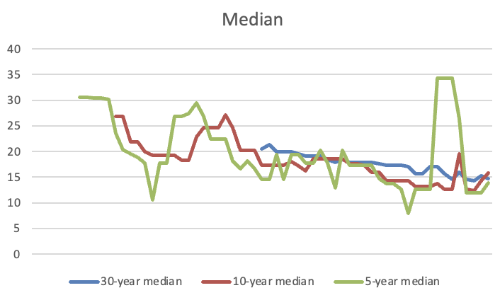
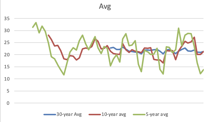
Decided to really drill down into the stats/trends of IAD snowfall. I'm sure it's nothing new, but the median really drives home the point that we no longer "average" 20 inches a season. It's more like 14-15 now, and that's with the big snow years thrown in. Take those away, we're at more like 8-12" median... and the downtrend is so striking compared to the "average" skewed by the occasional big dog. And this year we may not even get to the median! Excuse the ugly charts, but this shows the average 20" snowfall year is increasingly out of reach. And we're talking IAD numbers. I haven't even bothered to look at DCA. *Source: https://www.weather.gov/media/lwx/climate/iadsnow.pdf
-
Yep, and they need it. Badly.
-
Feel free to call bullshit, but I mean it. Of course I’d love to get 20-40” but the stats and trends don’t lie. The 20” average is likely outdated, and I’ve been adjusting my expectations accordingly.
-
All I’m saying is if we get 0 this year, how likely is it we will get 0 again next year? Maybe there’s a first for everything. Maybe your expectations are different, but I’d be content with 3”, let alone 7”
-
Good to know. I haven’t been looking at models since my last year here (2010) and I don’t remember the GFS being so bad with individual storms even inside 48-72h. It’s like they gone backwards to the 1980s modeling performance. At least the LR ensemble performance is somewhat credible.
-
EPS shows more red. And can we really trust the GFS? To add to my last post, if we do get zero’ed out this winter, at least we then know that there’s nowhere to go but up the following winter.
-
Frost is back. At least I don’t have to go anywhere, so I don’t have to scrape the car.
-
Models showing almost no precip for tonight in my area, and no front end thump for the weekend storm. Looking like a shutout so far, and may end up that way this year. Smart thing to do is take up another hobby, at least until the next el nino, and even that isn’t a guarantee (see: 97-98)


