Terpeast
-
Posts
5,326 -
Joined
-
Last visited
Content Type
Profiles
Blogs
Forums
American Weather
Media Demo
Store
Gallery
Everything posted by Terpeast
-
It’s awesome up here at deep creek. What a winter wonderland, my weenie soul needed this. my 2 year old loves the snow, too… kept saying “my snowman!” About 6” on the ground, maybe a little more. 26-27 F Will share pics later
- 302 replies
-
- 11
-

-
January/February Mid/Long Range Disco IV: A New Hope
Terpeast replied to stormtracker's topic in Mid Atlantic
Not too much though, or they’ll cut like all the others. -
January/February Mid/Long Range Disco IV: A New Hope
Terpeast replied to stormtracker's topic in Mid Atlantic
My “hopium” take is that the models may not be showing this now, but as a wave (in actual reality, not modeled reality) approaches the east coast with all those record warm waters, it’ll get more amped and draw the cold air in on the backwside. Again, a dose of hopium. Maybe just because I’m in a good mood as we’re about to head to the mountains soon. -
The “is it ever going to snow again” discussion.
Terpeast replied to psuhoffman's topic in Mid Atlantic
Yeah and I also noticed that a neutral that comes after a nina tend to be the worst seasons. Here’s hoping that we’re getting it out of the way this year, and that the fading nina is just a lagging indicator than a leading one. -
January/February Mid/Long Range Disco IV: A New Hope
Terpeast replied to stormtracker's topic in Mid Atlantic
I thought this thread would make it to 50 pages without going off the rails with insanity psychobabble. -
The “is it ever going to snow again” discussion.
Terpeast replied to psuhoffman's topic in Mid Atlantic
Let’s see, 2nd chart showing a flatter -epo ridge with -pna trough dumping west, a SER, and a cutter track (neut H anomalies SW to NE across central US through great lakes). Warm H anomalies over most of Europe. Looks familiar! We’ve been saying that the atmosphere isn’t really acting like a nina, but more like a nino (but not really). Appears to me that this is an enso neutral winter as a leading indicator ahead of a dying nina! -
January/February Mid/Long Range Disco IV: A New Hope
Terpeast replied to stormtracker's topic in Mid Atlantic
Still parsing the rain/snow line on Op runs 200+ hours out, aren’t we? -
The “is it ever going to snow again” discussion.
Terpeast replied to psuhoffman's topic in Mid Atlantic
Ok so maybe that’s not it. Maybe it’s down to the simplest answer staring right at us. As the arctic warms faster than the rest of the planet, the finite source of cold air becomes… even more finite. However, as the N-S temperature gradient becomes smaller, we still get blocking, maybe even moreso than before. Sometimes that helps us produce epic years like 09-10. Other times, because we have a smaller and more finite source of cold air, it hurts us by linking with the SER. Maybe that’s why Chuck has been rooting for a +nao lately, just to blunt that SER down. -
The “is it ever going to snow again” discussion.
Terpeast replied to psuhoffman's topic in Mid Atlantic
@psuhoffman I wanted to continue our discussion after your long post about the 1960s, but my brain is starting to check out from all this. But just one thing. With the common denominator in the 60s not being enso or mjo or the pacific, but persistent negative height anomalies in the west/central atlantic, I would think that is almost the mirror opposite of the SER/WAR we have now. I’m curious about low ACE <> WAR correlation, and whether the 60s was a higher than average hurricane activity decade. Would be interesting to look into ACE for that period while you’re at it. And if the upcoming nino also suppresses hurricane activity this year, and there IS a correlation with the WAR, I’m not sure how it’s going to help us next year either. Too strong of a nino, or too east based, it’ll probably lead to an above normal likelihood of another 97-98. -
Try Vietnam. Last year it snowed up to 2 feet at the summit of Vietnam’s highest mountain, sitting just north of 10,000 ft. It’s in Vietnamese, but there’s plenty of photos here: https://baotintuc.vn/anh/tuyet-roi-day-bao-phu-fansipan-ngay-28-tet-20210209101754824.htm
-
Looking good for us! Wife is excited. How do you think the roads are going to be up there Friday afternoon say between 2-4 pm?
-
January/February Mid/Long Range Disco IV: A New Hope
Terpeast replied to stormtracker's topic in Mid Atlantic
Well ya better start believing it because the sooner you accept such an outcome the easier it’ll get. -
January/February Mid/Long Range Disco IV: A New Hope
Terpeast replied to stormtracker's topic in Mid Atlantic
Color me surprised… not. I knew this would happen. Not trying to be a deb, and you all know I want snow as much as the next weenie. If we do get a good snow, I would go full Jebman on you guys. But tis not our year. -
January/February Mid/Long Range Disco IV: A New Hope
Terpeast replied to stormtracker's topic in Mid Atlantic
For sure, I would have done the same. Early on in the season, I was like “I have low expectations because its a nina, but it can’t be that bad” Now? “Ok, it is THAT bad” After we head up to deep creek this weekend and at minimum, see some snow on the ground and take in the winter wonderland, I’m moving on. I’m out. -
Rain/sleet mix in ashburn. Seeing ice pellets on my deck.
-
January/February Mid/Long Range Disco IV: A New Hope
Terpeast replied to stormtracker's topic in Mid Atlantic
We’re losing the window on the ensembles, too. Just look at the trends. -
January/February Mid/Long Range Disco IV: A New Hope
Terpeast replied to stormtracker's topic in Mid Atlantic
Still at range, we don’t want it on top of us past day 7. -
Cloudy and cold. Little or no precip in ashburn
-
January/February Mid/Long Range Disco IV: A New Hope
Terpeast replied to stormtracker's topic in Mid Atlantic
And for that, we have to kill the SER/WAR. As long as that is there, it’s very hard to lock in a 50/50 -
January/February Mid/Long Range Disco IV: A New Hope
Terpeast replied to stormtracker's topic in Mid Atlantic
Really informative, thanks for putting this together. Busy day at work today, but if I could add some of my thoughts to this, I’ll do it in the other thread. Thanks again. -
January/February Mid/Long Range Disco IV: A New Hope
Terpeast replied to stormtracker's topic in Mid Atlantic
Okay this is interesting because the 1960s were insane - why? Was that a window when the pac temporarily become more favorable combined with a -nao? Or did the 1960s do well DESPITE a hostile pac? Was there some other factor involved other than the nao? -
January/February Mid/Long Range Disco IV: A New Hope
Terpeast replied to stormtracker's topic in Mid Atlantic
Go by NWS. D0-1: short range D2-3: med range D3-5: long range D5+: fantasy range -
January/February Mid/Long Range Disco IV: A New Hope
Terpeast replied to stormtracker's topic in Mid Atlantic
Must have looked at the runs that didn’t show this. I didn’t see. So I guess we just look up to D7 and disregard anything past that. -
January/February Mid/Long Range Disco IV: A New Hope
Terpeast replied to stormtracker's topic in Mid Atlantic
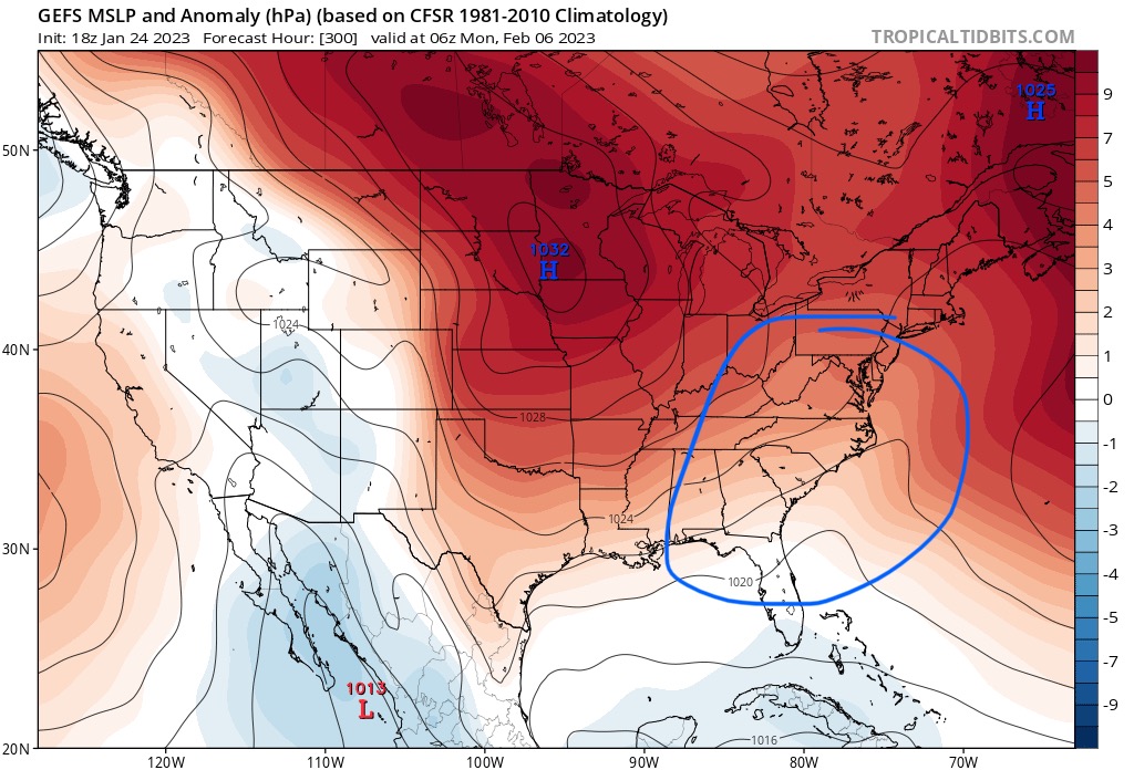
Other than h5 maps, I check mslp in the ensemble means. There’s a faint signal of lower pressure to the SE with high pressure to the NW. I have not seen a signal like this all winter. Not even for the december cutter or the recent Jan rainstorms. First I’ve seen this. Window feb 3-7. Usual disclaimer - just one run, could change, blah blah, just something to keep an eye on other than h5 and 850s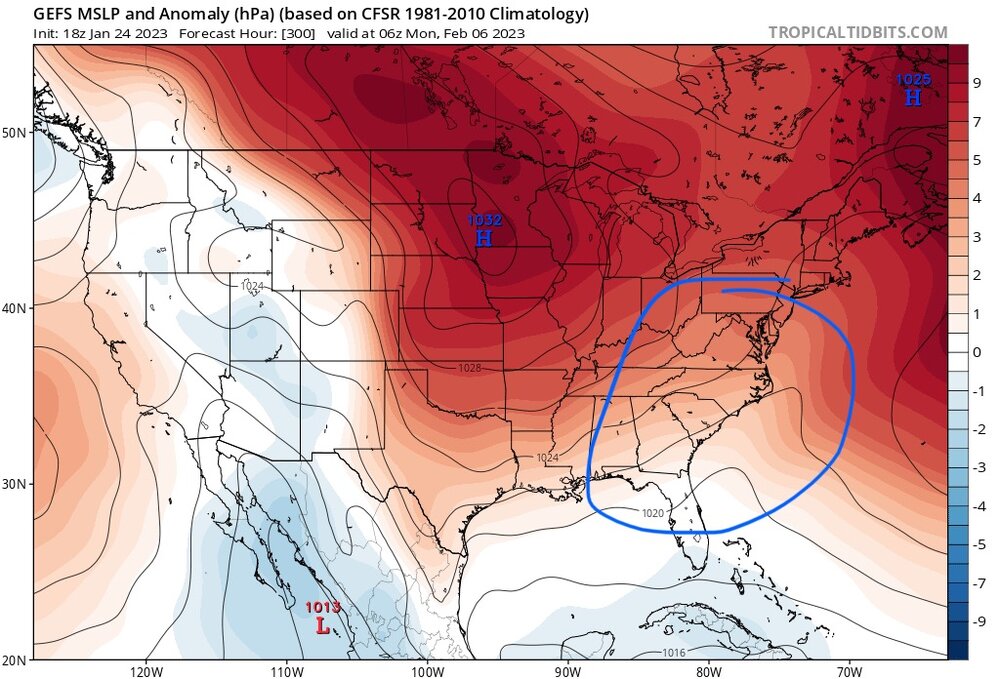
-
January/February Mid/Long Range Disco IV: A New Hope
Terpeast replied to stormtracker's topic in Mid Atlantic
From LWX: .LONG TERM /FRIDAY THROUGH MONDAY/... From Friday through the weekend and into early next week, the hemispheric pattern does not appreciably change. More specifically, this features an upper ridge over the eastern Pacific, another high near the Bahamas, and a deep upper low to the north of Hudson Bay. Split flow is evident in the guidance which carry waves across the western U.S. as well as within the cyclonic longwave flow regime over the central/eastern U.S. At this juncture, there is little to no interactions with these streams which is often the recipe for a more pronounced winter weather threat. You can tell that LWX is a little baffled at how this winter is going, huh?