Terpeast
-
Posts
5,326 -
Joined
-
Last visited
Content Type
Profiles
Blogs
Forums
American Weather
Media Demo
Store
Gallery
Everything posted by Terpeast
-
Perfect track rainstorm
-
Late February will be rocking. February Long range Discussion thread
Terpeast replied to Ji's topic in Mid Atlantic
Can relate with that. My little girl is the outdoorsy type, and she goes stir crazy if we’re cooped up inside for too long. Funnily enough she doesn’t mind the cold as long as we dress her warmly enough. -
No jacket needed today.
-
Late February will be rocking. February Long range Discussion thread
Terpeast replied to Ji's topic in Mid Atlantic
So my weekend plans will still be intact... As for this winter, we're down 35-3 late in the third quarter. It's 3rd and long against a stout defense (warm air). Looking like yet another punt... maybe we get the ball back last week of February with about 5-7 minutes left in the game. -
Late February will be rocking. February Long range Discussion thread
Terpeast replied to Ji's topic in Mid Atlantic
Just a gut feeling… i don’t think this h5 low closes and tracks as far south as its showing on the models. Maybe I’ve seen too many last minute north trends in my lifetime. *Not saying we get a result that favors us in the end (in case I get weenie tagged lol) -
Late February will be rocking. February Long range Discussion thread
Terpeast replied to Ji's topic in Mid Atlantic
Based on LWX’s AFD this morning, I think they disagree. Personally, I have no idea -
Late February will be rocking. February Long range Discussion thread
Terpeast replied to Ji's topic in Mid Atlantic
LWX says guidance might swing today because s/w entering better sampled zones now. Won’t be surprised if we see something very different later today or tonight -
Late February will be rocking. February Long range Discussion thread
Terpeast replied to Ji's topic in Mid Atlantic
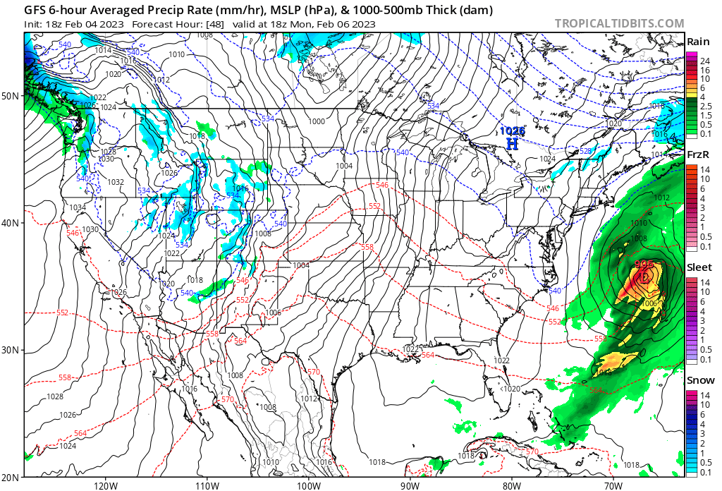
Looking more like a Jan 98 rainstorm for i-95 unfortunately -
Late February will be rocking. February Long range Discussion thread
Terpeast replied to Ji's topic in Mid Atlantic
Slower trend works against us because it gives cold air time to leave/modify -
Late February will be rocking. February Long range Discussion thread
Terpeast replied to Ji's topic in Mid Atlantic
Trending slower over past several runs -
Late February will be rocking. February Long range Discussion thread
Terpeast replied to Ji's topic in Mid Atlantic
LWX not biting yet. Maybe a good thing -
Late February will be rocking. February Long range Discussion thread
Terpeast replied to Ji's topic in Mid Atlantic
I was thinking that this is a qpf bomb, as currently depicted on this run. Doesn’t necessarily translate into bigger snows, if any. Worth watching. -
Late February will be rocking. February Long range Discussion thread
Terpeast replied to Ji's topic in Mid Atlantic
Fight club rule. We don’t talk about starting any threads. Especially if there is a trackable event. -
Late February will be rocking. February Long range Discussion thread
Terpeast replied to Ji's topic in Mid Atlantic
Not quite. Challenged, yes. But not decimated. No wind reversal -
Late February will be rocking. February Long range Discussion thread
Terpeast replied to Ji's topic in Mid Atlantic
Of those non-hits, how many were too warm and all rain? And how many were complete whiffs/non storms? -
Late February will be rocking. February Long range Discussion thread
Terpeast replied to Ji's topic in Mid Atlantic
Well, after I’ve already made weekend plans with the family, the models start showing some interesting things… -
Late February will be rocking. February Long range Discussion thread
Terpeast replied to Ji's topic in Mid Atlantic
From LWX. Bold is my emphasis . Further complicating this forecast is the cold air arriving on the back end of this system with the trough. The GFS and some of its ensembles bring that cold air in and still have some QPF around, thus producing some snow on the back side of the system. Do think the Canadian/European solution is a bit more realistic though, with drier air on the back side dampening precipitation chances. Certainly something worth monitoring in the coming days to see if a trend develops. -
Late February will be rocking. February Long range Discussion thread
Terpeast replied to Ji's topic in Mid Atlantic
Yeah I get that. My comment was more of a reflection of the forum’s overall mood than the models itself, though. Sometimes I try to make light of the situation because… it’s just weather. -
Late February will be rocking. February Long range Discussion thread
Terpeast replied to Ji's topic in Mid Atlantic
Don’t take offense, I’ve been skipping over your posts without reading them… but for this once, you actually said something pretty insightful. Next time we’re staring down a MECS/HECS, we won’t believe it until halfway through the event and we haven’t dry slotted or mixed. -
Late February will be rocking. February Long range Discussion thread
Terpeast replied to Ji's topic in Mid Atlantic
I’ll take a BN summer if we get interesting severe. Not like last year -
Late February will be rocking. February Long range Discussion thread
Terpeast replied to Ji's topic in Mid Atlantic
I’m about mostly checked out, but it’s a shame that this isn’t 400 miles further west. Where’s the west trend when we needed it?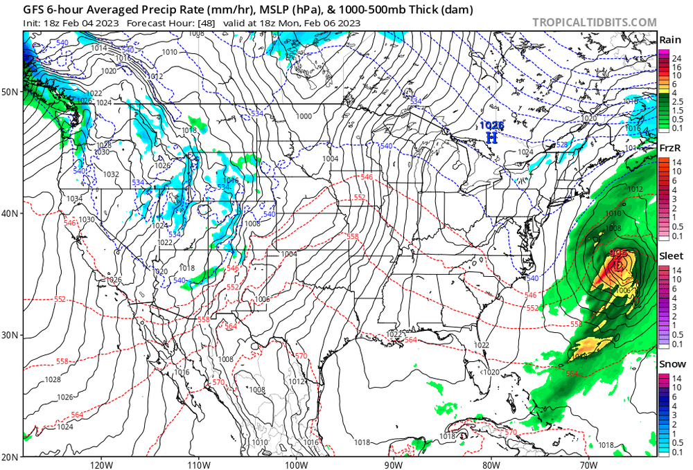
-
Low of 12
-
Its… cold.
-
Haven’t seen anything. Ashburn, 29
-
Late February will be rocking. February Long range Discussion thread
Terpeast replied to Ji's topic in Mid Atlantic
Ens showing a 1-2 day window of N/BN temps day 8-10, otherwise torch through and through