Terpeast
-
Posts
5,326 -
Joined
-
Last visited
Content Type
Profiles
Blogs
Forums
American Weather
Media Demo
Store
Gallery
Everything posted by Terpeast
-
March Medium/Long Range Thread: The Empire Strikes Back
Terpeast replied to stormtracker's topic in Mid Atlantic
Even the pros at LWX aren’t touching this at all. Mt Holly doesn’t think we’ll (the entire MA) get much snow out of this from the first storm. -
March Medium/Long Range Thread: The Empire Strikes Back
Terpeast replied to stormtracker's topic in Mid Atlantic
That gfs bomb ots is fine where it is at range. I don’t believe it will go that far ots because record warmth waters will keep the baroclinic boundary closer to the coast. But the way it bombs? I believe it. -
March Medium/Long Range Thread: The Empire Strikes Back
Terpeast replied to stormtracker's topic in Mid Atlantic
Odd yes, but I’ll take that h5 (maybe 50 miles south) and run with it. I don’t care what the 18z eps snow maps say. -
March Medium/Long Range Thread: The Empire Strikes Back
Terpeast replied to stormtracker's topic in Mid Atlantic
Except it didn’t for march 4, but different pattern I know -
March Medium/Long Range Thread: The Empire Strikes Back
Terpeast replied to stormtracker's topic in Mid Atlantic
Is that what we mean when we say the gfs caved? Wow, what a change over 24h
-
March Medium/Long Range Thread: The Empire Strikes Back
Terpeast replied to stormtracker's topic in Mid Atlantic
Something new that came up on todays model runs is a second wave following closely on the first one’s heels, not the one that comes almost a week later. Ensembles signal is faint but its there. Could get interesting if we get a follow up wave timed well with cold air after the first. -
March Medium/Long Range Thread: The Empire Strikes Back
Terpeast replied to stormtracker's topic in Mid Atlantic
It’s cold enough for a front end thump or mix east of the mountains, verbatim. -
March Medium/Long Range Thread: The Empire Strikes Back
Terpeast replied to stormtracker's topic in Mid Atlantic
Better set of runs today than yesterday. Could be that the models are initializing the block more accurately and we are starting to enter mjo 8 -
March Medium/Long Range Thread: The Empire Strikes Back
Terpeast replied to stormtracker's topic in Mid Atlantic
Maybe he got tired of dealing with the MA forum. He still posts in the NE forum -
March Medium/Long Range Thread: The Empire Strikes Back
Terpeast replied to stormtracker's topic in Mid Atlantic
Maybe with a stronger 50/50 we get more confluence. But if the wave ejects from the W too strong/amped, it can’t trend S -
March Medium/Long Range Thread: The Empire Strikes Back
Terpeast replied to stormtracker's topic in Mid Atlantic
Ok so not THAT different. Primary into OH, then maybe redevelop somewhere off the coast. -
March Medium/Long Range Thread: The Empire Strikes Back
Terpeast replied to stormtracker's topic in Mid Atlantic
Huge differences still even at 120 hr lead times. One would think they’d start coming into better agreement by now. -
March Medium/Long Range Thread: The Empire Strikes Back
Terpeast replied to stormtracker's topic in Mid Atlantic
Yeah, I wfh and so does my wife. We could have moved to tahoe or buffalo. But we chose here because our daughter gets to see my mom once a week and we both have friends in the area. Too important to pass up just to live in an area with more snow, which we could always visit on a chase btw. -
March Medium/Long Range Thread: The Empire Strikes Back
Terpeast replied to stormtracker's topic in Mid Atlantic
Doubt it. Maybe 60% of the previous normal will be the new normal. That’s what my trend graph was pointing towards. ~10 DCA ~14 BWI & IAD With a KU once every 6-8 years. Or something like that. -
March Medium/Long Range Thread: The Empire Strikes Back
Terpeast replied to stormtracker's topic in Mid Atlantic
Orientation of the block is better, too. -
March Medium/Long Range Thread: The Empire Strikes Back
Terpeast replied to stormtracker's topic in Mid Atlantic
Normal 850 temps are 0 in mid-march for DCA, as opposed to about -4 in Jan. So they need to be below normal to support snow as long as the BL is saturated and/or isothermal -
March Medium/Long Range Thread: The Empire Strikes Back
Terpeast replied to stormtracker's topic in Mid Atlantic
Well maybe that big 50/50 will stick and manage to cool those waters a good bit -
March Medium/Long Range Thread: The Empire Strikes Back
Terpeast replied to stormtracker's topic in Mid Atlantic
@psuhoffman I’m not even sure its solely the pacific anymore like I thought it was back in Dec-Jan. Someone raised a good hypothesis earlier in this thread - what if [X factor] is responsible for amping waves out of the W too much too soon, instead of digging or sliding to the S of us? It makes sense if we consider the warmer gulf waters + carribean high supplying warm moist air to any wave that rolls over the rockies. So one of the two things has to happen - laws of physics - a) move further N/W across the baroclinic boundary that was/is being pushed north, or b) amplifies into a huge monster which isn’t good for us either because we don’t want an early phaser for a MA snow. What would it take for a third thing to happen? C) hold a ridge over the west, cool the Caribbean waters a tad, and get something to slide S of us. -
March Medium/Long Range Thread: The Empire Strikes Back
Terpeast replied to stormtracker's topic in Mid Atlantic
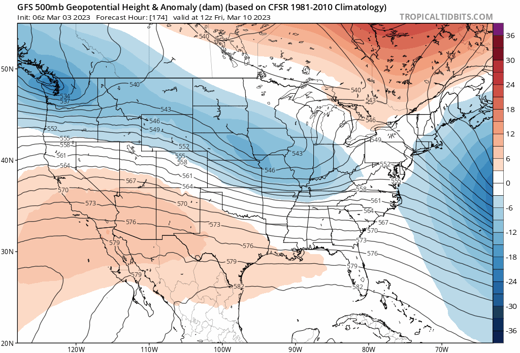
I’d say wait till the ens but I have a feeling they will move towards the op esp since op gfs seems to have latched onto a new idea -
March Medium/Long Range Thread: The Empire Strikes Back
Terpeast replied to stormtracker's topic in Mid Atlantic
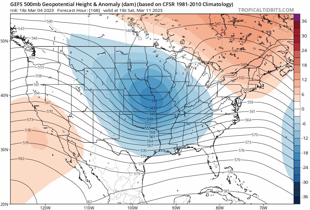
-
March Medium/Long Range Thread: The Empire Strikes Back
Terpeast replied to stormtracker's topic in Mid Atlantic
18z gefs seem to be weakening the epo ridge while intensifying ao/nao. Is there an analog for that? -
March Medium/Long Range Thread: The Empire Strikes Back
Terpeast replied to stormtracker's topic in Mid Atlantic
Could be that the models are underestimating the block and or overinitializing current conditions with the old pattern still in place. -
March Medium/Long Range Thread: The Empire Strikes Back
Terpeast replied to stormtracker's topic in Mid Atlantic
Ops seem to want to slow the vorts down and amp them, while many ensemble members kick them out faster and less amped. -
March Medium/Long Range Thread: The Empire Strikes Back
Terpeast replied to stormtracker's topic in Mid Atlantic
Both 12z op runs of the globals didn’t turn out good scenarios today. Hope this isn’t a sign of a trend. -
Sleet mixed in with rain. Pellets on deck. Ashburn, 40