

Terpeast
-
Posts
5,326 -
Joined
-
Last visited
Content Type
Profiles
Blogs
Forums
American Weather
Media Demo
Store
Gallery
Everything posted by Terpeast
-
My 2022-23 winter outlook & "what went wrong" Post-mortem
Terpeast replied to Terpeast's topic in Mid Atlantic
Yeah, it’s quite possible that ninas will become more commonplace in this warmer climate. And I’ve alluded to that possibility, too. My biggest fear is that if mid-lat SSTs warm faster than tropical SSTs, will we find ourselves in a permanent la nina state? -
Shared my post-mortem post about this winter, and where we go from here - if anyone's interested in reading.
-
My 2022-23 winter outlook & "what went wrong" Post-mortem
Terpeast replied to Terpeast's topic in Mid Atlantic
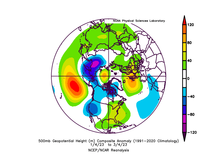
The stats Here are the temp anomaly stats at IAD in F: Dec: -0.8 Jan: +8.4 (!!) Feb: +8.2 Mar: +2.3 (through 17th) Well, what can I say? After correctly predicting a warm Nov and cool Dec, my outlook completely fell apart as soon as the post-Dec cutter arctic cold left the building. Although it didn't feel like an all-out torch, we had constant 50s through the whole winter, including prime climo for snowfall. We hardly got below freezing most nights. What the hell happened? Here are the NCEI anomaly maps for DJF. It's one thing to have a winter with slightly above normal temps (+1 to +3), but THIS is a whole another level. No wonder we got no real measurable snow. Remember, our climo 850mb temps are around -4 to -5 C in Jan-Feb, and even if we were +2 or +3, we would still have gotten snow albeit less than climo. Or a big storm with 0 to -1 850s hugging the fall line putting us above climo. But this was what we were up against (credit to CAPE): Highly anomalous aleutian high that rarely pushed east or poleward, helped dump cold air from Siberia (which had record cold) into the West. What caused this anomalous aleutian high? - Expanded hadley cell (credit to Chuck and PSU) - A moderate but very well coupled La Nina (with a modoki-ish look = terrible for us) - Extremely and deeply negative PDO (record values leading into the winter) So it was no surprise that we had a persistent SER/WAR throughout the whole winter. Even when we had a PNA ridge "trying" to develop over the west, a constant stream of troughs thanks to that aleutian ridge kept pushing the PNA ridge over east, suppressing any preceding wave, then pushing the boundary north of us, and allowing any succeeding storm to cut. I'm sure the warm Atlantic waters did not help us either, but I think that has more of a downstream effect - worth noting that Europe had a record warm winter as well. Could be an effect of the warm ATL SSTs. Even a SSWE could not save us. It did for NE, but the W trough / Aleutian ridge successfully ran the clock out on us. Okay, so where do we go from here? I think the lesson learned here is to not rely too strongly on analogs from the past, earlier than 1990 or so. More weight should be on analogs in the past 10-15 years, even though the sample size is so tiny. My best analog was 1985-86. But that winter was much MUCH colder than this one. It turned out to be a disastrous mismatch, and a failure on my outlook. A better match would have been 2011-12, which was on my analog list. But my personal bias prevented me from putting more weight on it as I should have. As it stands now, this winter is in its own league with EXTREME warm anomalies with no comparison to any winter of the past. It is now a new analog to base future winter outlooks next time we have a La Nina coupled with +QBO. So... is it ever going to snow again? Yes. 100%. But will we snap back to climo again? I agree with PSU that no, we won't. I believe our new normal is 60-70% of previous climo. Meaning ~14" for IAD, or ~10" for DCA should be the benchmark of what to expect in winters going forward given the warmer climate. However, that doesn't mean we won't get a 2' blizzard ever again. Remember our climo 850s, even if we adjust for the warmer climate, are still below 0 for a solid 2 months. If we get an El Nino, -QBO, a sustained +PNA ridge, and an active STJ, we just need a good wave to traverse the south without overamplifying too soon. Then we get hit even with the 0 line straddling the I-95 corridor. And all we need is one good hit to reach climo or above. I don't think we've reached the tipping point where 850mb temps cannot be 0 or below for our area when we get a wave to approach us. The 3-4 bomb cyclones that struck the immediate MA coast in the last several years is proof of that, in my mind. Maybe someday we reach that tipping point and the only place it snows is in the mountains above 2k ft. But I don't think we've reached that point yet. That said, the smaller events we used to get from clippers or from front-end dumps with primary lows to the NW, are fast dwindling and I don't think we get those back. The next El Nino will be the real test of this, though. Could it bring back big winters like 02-03, 09-10, 13-15, or will it just flood the NH with more and more warmth and set a new climate baseline?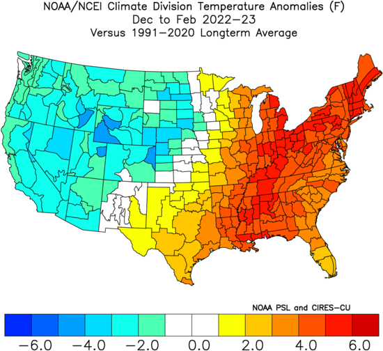
- 29 replies
-
- 12
-

-

-
The gulf and NW atlantic are so warm though. Wondering if we have any good comps for that plus -pdo/+enso
-
Yeah and that trough is still dumping into the west coast. Let’s just hit the reset button and get it done with.
-
See you in the severe wx tracking threads soon-ish.
-
Fool me once…
-
This winter was the worst I’ve ever seen in my life, it just refused to snow as if a cruel joke was being played on us. But I am pretty confident that we won’t get back to back shutouts. It can’t get any worse than this. And it almost certainly won’t be this bad next winter.
-
Idk, there are always exceptions and 2019 was a weak nino that failed to couple. I haven’t really dug into this and not sure I want to bother.
-
Not surprising. Some ninos just don’t play out well. Post-nino neutral winters have been good for us, afaik, while post-nina neutrals have been awful.
-
Amazing how the W trough just keeps pinwheeling out there. Tahoe is going to get buried alive.
-
I don’t know. Depends on strength and pdo Better than this winter? Probably
-
Check the cpc enso update weekly writeup. Long term pac sst map looks basin wide
-
That’s a 3-incher of a qpf bomb. Weenie in me says that’s a preview of what’s to come in the next nino now that the nina is all but dead. Question is, will we get the cold air next time around? (next winter, I mean)
-
Stopped a while ago, but just now started up again.
-
Light moderate snow, ashburn. 37. Not sticking. Decent snow TV. Did a jebwalk
-
And NOW it just started. A few flakes here and there.
-
Glad you guys are seeing snow now! Still waiting for it here.
-
Returns seem to be getting heavier as they go east of the mountains. Getting closer to here. Nothing yet…
-
Just cloudy in ashburn. 37
-
Map says it all. Most cold air concentrated in siberia with a secondary lobe of cold centered over CA. That’s what I was just telling psu a few minutes ago. Let’s see if a moderate nino can flip this. Btw, you saved me from spending a few hours writing that post mortem just with that map.
-
Ok in your feb 2010 map, most of the cold was in siberia but that secondary lobe of cold was right where we wanted it for it to work for us. This year? The secondary lobe was centered in CA. It snowed all the way down to where it rarely snows, and I’m not talking about climo at 8,000 ft which is irrelevant for us. What’s relevant is where that cold air predominantly goes. This is why I remain optimistic that we will still get big snow years, even while we lose the smaller events in most other years.
-
If I remember correctly, siberia had record cold through most of the winter. Cold air is a finite source, especially now, and it seems most of it just went to the other side. And maybe a smaller lobe or two dumped into the west. Could be just one of those years. Maybe next time we get the cold air dumped on our side.
-
I hope it’s nothing like last year when storms just up and vanish right on our doorsteps
-
Yep, onto severe wx tracking.