

Terpeast
-
Posts
5,326 -
Joined
-
Last visited
Content Type
Profiles
Blogs
Forums
American Weather
Media Demo
Store
Gallery
Everything posted by Terpeast
-
There was another paper I came across that said that wwbs may not necessarily lead a nino. I forget where though.
-
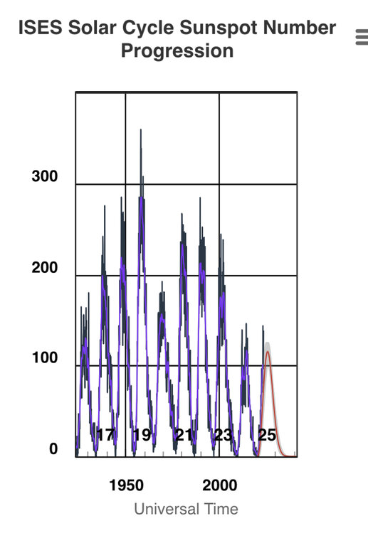
As far as solar goes, I don’t think our current cycle is that high. We’ve seen much higher before. Don’t think I would give it much weight unless solar activity doubles from where it is now, which I doubt will happen.
-
DCA 100 IAD 101 BWI 101 RIC 99
-
Take away the date/time stamps and gpm values…
-
Topped at 93 in ashburn. Hot and dry
-
I’m working on a side project to try and prove this out by using adjustments on daily temp and precip data at KIAD including SWE, to today’s climate to tease out whether a 15” storm in the 60s, 70s, or 80s would actually produce more today. I will also tease out, statistically, on how 2-4” events from the past would be affected in today’s climate. Hopefully I’ll come up with the results this summer.
-
And I also want to see 850mb temps (idk if that’s available on those seasonal forecasts). Our DJF climo is -4C at that level, plenty cold enough for snow. So near normal climo would be good enough.
-
Looks that way. Just looking at that chart, you’d think 2022 was an interesting year compared to the 80s and 90s when I grew up here. But it was the most boring severe wx season I’ve ever seen. The 90s were far more interesting, and even witnessed a few hailstorms. One produced sizes between golf balls and tennis balls.
-
2019 must have been a fun one!
-
That’s a bazooka right there. Can only hope it can get close to verifying.
-
I’ll take it!
-
DCA -0.3 96 NYC +0.8 97 BOS +1.2 97 ORD +1.0 95 ATL -0.6 98 IAH -1.6 102 DEN +0.5 99 PHX -0.8 117 SEA +2.0 99
-
Since about March, those anoms have been propagating W -> E, so while we may see a trade wind burst starting on the 10th, there’s a WWB at the same time around 90E. That may propagate to near the dateline through July like the early May WWB (which barely made it over the dateline by late May). So not all hope is lost yet.
-
May will likely finish below normal at IAD. Not including 5/31, we’re at -1.8F so far.
-
Well, he’s not all that wrong. If I’m seeing non-English tweets being posted here (a primarily English speaking forum) in support of a super nino, I gotta say you’re digging pretty deep. At least bluewave backs up his own analysis with data, even if I don’t like where the data is pointing towards.
-
Yeah, I still don’t understand the talk about heading into a super event this year. This one’s likely going high-end moderate, tops.
-
Getting a nice round of rain. Probably not enough to put a dent into the drought, but I’ll take it.
-
Best day of the year weather wise. 70s minimal humidity with a breeze. Went to a park with the kiddo, lots of people and families out. And for once, it didn’t rain on Saturday
-
Is that the GFS forecast you usually share here? Looking at the dateline between now and June 6th or so, that's quite a change from previous forecasts. Previously, it was mostly blue, but now it's mostly neutral. Could be a sign of the models catching up to the transition? I don't pay attention to anything beyond 7 days so the stronger trades on June 6th and onward in this run may or may not actually pan out. But we're still not out of the spring predictability barrier, so.
-
As would I. I don’t want to see a high-end strong or super as 1) that would flood the entire CONUS (and globe) with excess warmth, and 2) it may kick off yet another multi-year nina.
-
This, to me, sounds like further validation of the recharge oscillator model for enso.
-
I was thinking the same the other day
-
Forecast looks to weaken the trades slightly at or slightly east of the dateline over the next ~7 days.
-
Milky white sky today. Smoke from canada fires?
-
2023 Mid-Atlantic Severe Wx Thread (General Discussion)
Terpeast replied to Kmlwx's topic in Mid Atlantic
Pulled from CPC's enso update. Could be an interesting summer for severe wx?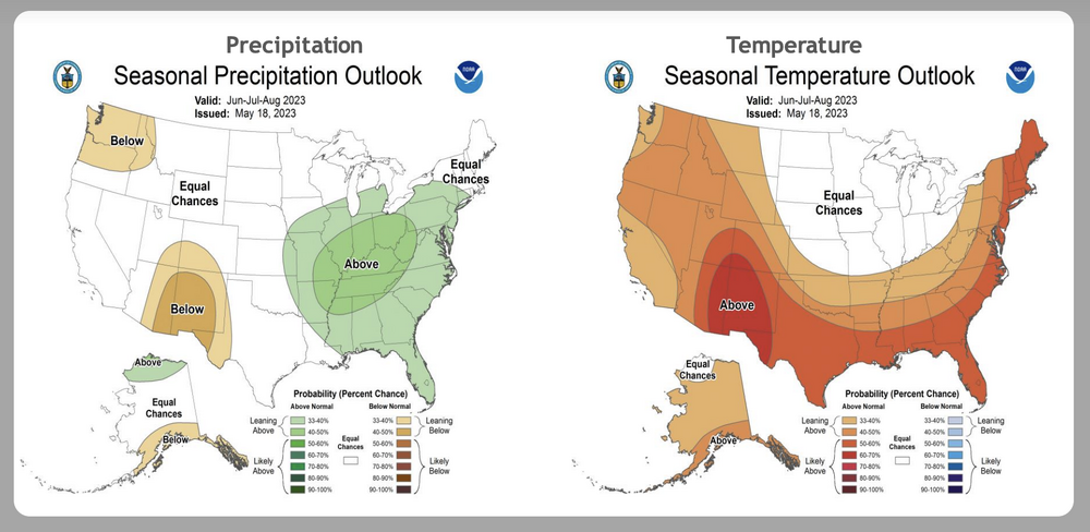
- 2,785 replies
-
- 1
-

-
- severe
- thunderstorms
- (and 3 more)


