

Terpeast
-
Posts
5,326 -
Joined
-
Last visited
Content Type
Profiles
Blogs
Forums
American Weather
Media Demo
Store
Gallery
Everything posted by Terpeast
-
Got jumped. 5 minute shower. Ridiculous.
-
0.07”. Playing for scraps
-
Nice cell forming north of Warrenton and heading for Manassas
-
Coming down good. Back edge coming fast, though
-
Mod rain, yellows incoming. I'll definitely take what I can get.
-
really like the enso orientation here, but global ssts are frighteningly warm all over
-
I’ll explain that in more detail when I finish the project, but basically detrended the temp time series, then used empirical relationships between actual temps and snowfall to calculate new snowfall totals based on detrended temp data. I’ll also list my assumptions, rationale for using these methods, and any weaknesses each method has, for full transparency’s sake. I’ll be the first to admit that it probably won’t pass the muster of academic peer review, but it’ll hopefully satisfy my (and maybe the forum’s) personal curiousity on what we can expect from future winters.
-
I don’t think it’ll be that bad either. While 97-98 is likely off the table, 72-73 is still a valid analog and probably will remain so as long as the PDO is negative. If I recall correctly, 72-73 was a snowy winter in the SE with near normal temps in the MA. Should that happen again with storm tracks shifted slightly north, the outcome may be a different result than that winter.
-
Agree. 1.5-2.0 should be the sweet spot for the MA. Less than that, too weak to fully couple and weak/no STJ. More than that, warmth overwhelms.
-
Seems with this week’s CPC enso update, the models backed off from a high-end strong/super scenario. Running low-end strong at the peak now. 1.5-1.7 or so.
-
0.33” today. Seemed like more with that last gasp cell though. It’s something.
-
I’m still not sure a five year old would understand this…
-
I'm not finished yet, but my preliminary results using one statistical method involving detrended temperature data showed a 16% reduction in snowfall overall. Out of all snow "events" (anything over 0.5" I count as an event and omit the rest): - 32% of them would have decreased snowfall in today's climate if they happened now than some X date in the past (e.g. an 8" snowfall in 1970 would be only 4" today) - 15% of them would be "total losses" (complete rainstorms) - 34% of them would see no change (similar accumulations) - 19% of them would actually see increased snowfall with bigger accumulations Of those 19%, I can highlight a few examples of very cold storms where a few degrees increase wouldn't flip it to rain, but would actually juice up the storm: 1) Feb 1979 (PD1) would have dropped 22" if it happened today rather than 16" at IAD 2) Feb 1983 would have dropped 30" today instead of just 23" (!!) 3) Jan 1996 would also have dumped 30" instead of 24" Then as we get into more recent storms like 2010 and 2016, the effect would be minimal because the temperature difference would be minimal. Interestingly, in the first 2010 storm, day 1 yielded 4" less, but day 2 yielded 2" more, so the result was 30". The actual was 32.4", so the loss was minimal, but more on the front end of that storm when the BL temps were still warm-ish and lots of snowfall was lost to melting. The 2016 storm had almost no change (obviously). Now, on the flip side... how many major storms did we lose? 1) We lost a footer in Feb 1987... assuming my method is correct (more or less), that storm would be the perfect track rainstorm. Total shutout. 2) There were four 8" storms throughout the 1960s... and we lost them all! Four 8-inchers in the 60s got zeroed out. (though there were another 3-4 storms in the 60s that made up for those losses by adding more snowfall... one 10" storm would produce 15" today, for example). So this was a qualitative look at how snowstorms from the past would perform in today's climate. It was exciting to share, even though I'm not finished with it yet. I haven't looked at ENSO, PDO, and other methods that may possibly affect snowfall like adjusting SWE, and so on. Still hoping to get full results out in its own thread here.
- 921 replies
-
- 10
-

-

-
Yeah I was thinking that even if the nino is basin wide, or even with a slight east lean, the WPAC warm pool might pull the forcing a little bit further west. We could see split forcing in the WPAC and EPAC, and then the MJO might punch through and these centers of forcing could combine in those locations displayed above. Also, interesting to see slight -VP anomalies across the southern US. Strong STJ signature?
-
Ok, I mean, who listens to JB anymore these days?
-
He didn't say modoki, he said basin wide
-
Low of 52. Finally see blue skies again
-
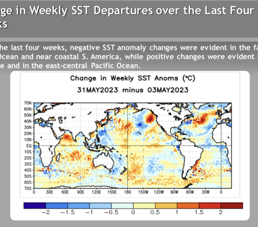
I’d wait a few months longer before prescribing a -pdo with +enso. Although that warm tongue east of Japan is persistent, note the trends over the past 4 weeks in the central-east pacific.
-
AQ is much better now. Thinking the worst is behind us now. Unless HRRR has another round for us overnight.
-
They’re giving it a 56% chance of a strong nino, and 84% chance moderate or higher.
-
I saw that in 2014. Major inversion you couldn’t see the city from the plane descending out of the mountains into SLC. Then drove up to Logan, and it was -10F and I couldn’t even see the surrounding mountains. It was all white.
-
Donned N95s when I went out this morning. Was planning to take my wife out on a date in the mountains today, but took a rainch- .. uhh, smoke-check instead. Next week probably. AirVisual says 281, Purpleair says 369.
-
All I see is brown
-
I use the AirVisual app
-
AQI stuck at 170-175 all morning through noon