

Terpeast
-
Posts
5,326 -
Joined
-
Last visited
Content Type
Profiles
Blogs
Forums
American Weather
Media Demo
Store
Gallery
Everything posted by Terpeast
-
It was strong. 1991-92 is low end strong, 2009-10 is high end moderate. A bit misleading, though
-
Hopefully not as bad as the first time. But every time we get sustained NW flow, we’ll get some of it at least until fall.
-
May be short lived. All ens still show a central/west ridge with a downstream trough in the east. CFS weeklies has it all the way through end of aug
-
Spoke too soon, nearest station 1/4 mile from me reported 0.37” total this morning. I’ll take it.
-
Agreed. The gold standard would be to re-run models with initializations going back to 1950 adjusted to today’s climate, and somehow not allow the models to not revert to the previous climate state. That way it incorporates all (well, most not all) non-linear processes, but that takes enormous resources that I and most of us don’t have.
-
Picked up 0.2”
-
Yeah, my lawn is 80% brown. I may have to water my dogwood tree soon, I don’t want it to die.
-
Yeah, such a small difference in temps would result in a drastically different outcome. As said in the MA subforum, I’m working on a project to clarify what we can expect in future winters by adjusting historical analogs to today’s climate. I still need to get it across the finish line, but my prelim hypothesis is that we’ll lose previous 32-33F storms to rain in new climate, while other (colder) storms would be even more juiced. Feb 87 is the biggest “loss” because it won’t take much to flip the whole thing to rain all the way to the mountains. Otoh, pd1 79 and feb 83 would produce astounding totals if they happened today in a warmer climate. I’m talking widespread 30” with a 40”+ jackpot potentially
-
While we would most likely lose the Feb 87 paste bomb were it to happen today in this climate, I would roll the dice with 86-87 any day.
-
Same. I wasn’t supposed to hit 90 or above here today. Got up to 92
-
Up to 91 now
-
16z hrrr says what line? I think we’re pretty much done, save for an isolated tstorm somewhere south of here
-
Time to think cold. What is your favorite snow memory?
Terpeast replied to ldub23's topic in Mid Atlantic
Also I haven’t seen anyone mention the Feb 2006 storm. We may not have gotten the sheer accumulations like 96, 10, and 16, but it was memorable in that I stayed up all night to watch the storm unfold. Rates were awesome. Near whiteout conditions at the height of the storm -
Time to think cold. What is your favorite snow memory?
Terpeast replied to ldub23's topic in Mid Atlantic
The 09-10 and 1996 storms aside, my favorite childhood memory was the 1987 double whammy. That marked the beginning of my weeniehood. My mom has pics of me in the 1983 storm where the snow was higher than me, but I was too young to remember. -
0.10”
-
Hard to tell how much rain I’m getting because its dark, but the ground is wet.
-
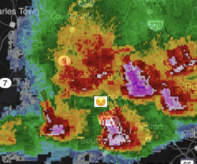
Still a ways to go, but filling in from the SW nicely. Can this reach Loudoun? TBD
-
I see that too, and that redevelopment is also fizzling Edit: I hope you’re right as is nw balt, but I’ve gotten burned one too many times this season.
-
Radar looks like a DC split. About to get gapped again
-
2023 Mid-Atlantic Severe Wx Thread (General Discussion)
Terpeast replied to Kmlwx's topic in Mid Atlantic
Radar out west looks good and a flood watch is up. I want to believe…- 2,785 replies
-
- 2
-

-
- severe
- thunderstorms
- (and 3 more)
-
91/75. Oppressive
-
2023 Mid-Atlantic Severe Wx Thread (General Discussion)
Terpeast replied to Kmlwx's topic in Mid Atlantic
Yeah, even though I didn’t get much rain imby, I saw a lot of very gusty winds. Likely over 50 mph. My toddler was spooked. -
What more needs to be said?
-
4 cells around me, not a drop. Yet. very gusty winds, temps dropped to 82
-
93/70 ashburn. Temps overperforming as expected because its been so dry

