Terpeast
-
Posts
5,326 -
Joined
-
Last visited
Content Type
Profiles
Blogs
Forums
American Weather
Media Demo
Store
Gallery
Everything posted by Terpeast
-
That doesn’t make any sense. You can change the climate normal period before you render the plot.
-
Why are you using the 1971-2000 climo when 4 out of those 5 winters are later than 2000?
-
Yes, and the qbo is double digit negative and falling is a good sign.
-
I’ll have to look at the ao/nao numbers again for that season, but given How drastically different the 3 seasons I raised here is proof enough that the polar domain is going to be a determining factor for 23-24 given the enso and pdo similarities across all three. Bluewave and I were just looking at both sides of the same coin here.
-
That time frame was when it started flipping. I was looking all the way back to mid 2007 when the PDO went negative, deeply so, and remained that way until around summer 2009, when the el nino atmospheric response began to assert itself right in that autumn timeframe.
-
I also looked at the PDO index leading up to each winter, and before 09-10, there was a long duration strong negative PDO before becoming neutral. So I think the atmospheric response to the el nino was driving the bus that winter, and the pac ssts was just a response to the aleutian low, which was a response to the forcing from the CP nino. I don’t think the pdo ssts are the driver unless they are extreme.
-
2009-10 was similar, except the polar domain (nao) was negative while 04-05 & 94-95 was raging positive. That was the difference, and not so much the tropics or pacific.
-
No need to get so worked up because I used a different matching tactic than you did, and I haven’t even gotten to the maps part of my whole analysis yet. I already spent 3 hours on collecting the variables that I think are important, and it’s getting late. I’m not going to pull an all nighter just to complete the analysis the way you think should be done. Chillax. Sheesh.
-
I think you guys are going to like the analog matches I've found for this winter based on ENSO, PDO, QBO (and whether it is rising or falling), MEI, ONI vs. Nino 4 (where -vp forcing is favored)
-
Did a prelim analog analysis... Collected all El Nino years, from weakest to strongest, and cross ref'ed them against MEI, Nino 4, difference between ONI and Nino 4 (to see if it was east based or not), PDO, QBO, AMO, preceding base state (whether the nino came after multi-year ninas and -PDO regimes). Once I filled in all this data, I filtered out all the east-based ninos, +PDO years, and +QBO years... any MEI lower than 0.5 and any higher than 1.1. I got only one analog match: 2009-10. Not a perfect match by any means... but it's all I've got right now, and I'm certainly not going to base my winter outlook just on one season. So I'm just going to wait for another month's worth of data, and loosen my matching criteria to include more analog years so I could use a mix of at least 5 seasons. Now if I ignore the QBO, I get: 94-95, 04-05, 06-07, and 09-10. At least the latter three had "falling" QBO, so I could exclude 94-95 based on which direction the QBO was evolving those seasons.
-
QBO came in at -13.58 for Sept. Still falling.
-
Yeah, I don't think it's best to use past volcanic analogs like Pinatubo in 1991-92 because that was a different type of eruption with sulfur not H2O vapor.
-
I think we have a good sense of where this nino is going to peak. So it’s time for me to pick my analog years. I’ll be using this criteria: - early nino peakers - MEI between 0.5 and 1.0 - neg qbo - ascending solar/near solar max - neg pdo (even if only slightly so) - warm AMO - any nino that comes after a triple nina Those are just off the top of my head. And then I’ll narrow to a short list of top 5-6 analogs, and adjust them a few degrees warmer if they are older than 1990 and of course, super ninos will be excluded because we almost certainly are not going super.
-
That’s pretty much it. I shared the above threads because they had the numbers to back it up.
-
41.5
-
GaWx in the SE forum sniffed out a partial correlation between BN Oct and BN winters in the SE up to MA. He made a very convincing case to root for a cold Oct over a cold Nov. I’ve also anecdotally observed that cold Novembers usually lead to milder winters especially in ninos.
-
I think it is a very reasonable winter outlook.
-
Although I was never on board for super, I was thinking high end strong like 1.8-1.9, but even that seems too ambitious. I think the next 3-monthly ONI value will come in at either 1.4 or 1.5, so that may be the peak value for this nino, with an outside shot at 1.6 if we get a last ditch KW this month or early Nov.
-
Obviously something is driving these downwelling KWs without significant WWBs.
-
Picked up 0.07” yesterday. Morning low 44. 62 now
-
Thats a promising sign, and one we’d prefer to see in October than November
-
The good thing about the mjo is that once it gets into phase 7, it opens up the possibility for a big EC snowstorm. Look closely at @GaWx charts… the biggest KUs start as waves entering the CONUS when we’re in 7.
-
There’s a chance it does. As I showed in my mjo field, 4 is still open for business despite current suppression. We’d just have to wait it out.
-
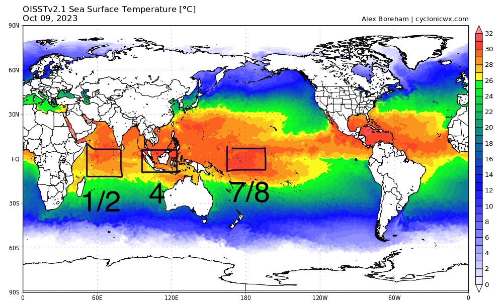
Excellent post on the MJO by @GaWx! I think what would really help with our winter outlooks is to project which MJO phases will be “open for business”, and we can start with looking at the warmest ssts adjacent to the greatest gradients in the MJO field: Right now, and this is just today’s snapshot, we could say that 1, 2, 4, 7 and 8 could potentially be open for business, or at least get the MJO out of COD for those phases. We probably don’t want 4, but this winter I think we’ll have to deal with short lived incursions into the right side of the graph… wait them out until it rotates back to the left side.