Terpeast
-
Posts
5,326 -
Joined
-
Last visited
Content Type
Profiles
Blogs
Forums
American Weather
Media Demo
Store
Gallery
Everything posted by Terpeast
-
What site are you using to run these nino3-H5 charts? I’d like to try the same, but using nino4 instead
-
39. One of the colder mornings so far
-
Hunga Tonga–Hunga Haʻapai
-
Not much except maybe a glimmer of hope that HTHH won’t deliver an +AO death knell. Also worth noting that after a SSW (and/or Strat PV split) back in Feb, mutiple HL blocking episodes ensued for several months afterward lasting through all summer
-
While 09-10 is a good match for this year... 91-92 is also a good match, especially if HTHH's strat vapor effect is to counter the -QBO to produce +AO (which is TBD). Two vastly different results with similar ENSO/PDO/QBO setups. This winter will be decided by the polar domain, I am certain of it.
-
As far as the missing cold subsurface in the WPAC, maybe that's not a bad thing? It could indicate a multi-year nino instead of a one-time blast before a return to la nina conditions. Your guess is as good as mine.
-
We’re still comparing 2023 to other super ninos, which we know isn’t going to happen this year. I’d replace this with a comparison to the moderate/strong nino cohort.
-
Yeah, after a warm start, it feels like the Octobers I remember growing up with.
-
43 low
-
Yeah, true. But if we’re going to have a snowy winter, I want to correctly predict it
-
Perfect!
-
When do the November runs come out? Thinking of holding off on my winter outlook till then. Too many moving variables atm
-
Regarding comparison to 18-19, @brooklynwx99 just presented an open-and-shut case here. Previously, I had 18-19 as one potential analog, but not anymore.
-
If you were straddling the r/s/mix line, then maybe. Otherwise they’d be even more juiced The Feb 1987 storm would be all rain today, though.
-
Yeah, agreed. That’s the direction I’m leaning towards atm
-
Yeah I’ve seen this before, and it’s a great reference to simplify things. But I’m taking a broader Pacific-wide view of the PDO, not only the basin north/NW of Hawaii. I also look at the pdo cycle 1-3 years before each preceding winter analog season to get an idea of how conditions evolved up to each winter. The part you and I agree on is that there will be competing factors this winter, with the -pdo working against us. But I believe the “negativity” of the pdo will weaken, and the basin-wide (or west-leaning) enso will eventually win out. meanwhile, of course we are going to see -pna episodes that’s going to get people here concerned (while its of no surprise to me).
-
I think that’s where you and I differ a bit. I don’t think the PDO has to flip positive for the MA/SNE to get a decently productive winter. A +PDO, especially if strong, also brings its own set of challenges, like a too-strong aleutian low flooding the CONUS with mild air a la 97-98. It’s a double edged sword, and as the 1960s and 09-10 has proved, we don’t need the PDO to flip in a dramatic manner, just move towards the neutral range.
-
Amazing, the marine heat wave off Japan is nearly gone. Now lets work on the ssts north/NW of hawaii. This upcoming rex block might help with that, even if it causes a -pna for us in the process.
-
I actually think its the other way around. Based on my top analogs so far (could change) I’m seeing a signal for a wet winter with a STJ. Whether that is accompanied by cold temps is tbd.
-
A storm out of the gulf in October would most probably be tropical, and el ninos tend to suppress hurricane activity in those parts. It’s getting quieter now. let’s get to mid January, and if we haven’t had anything come out of the gulf and no models are showing anything 2 weeks out, then maybe it’s time to get concerned
-
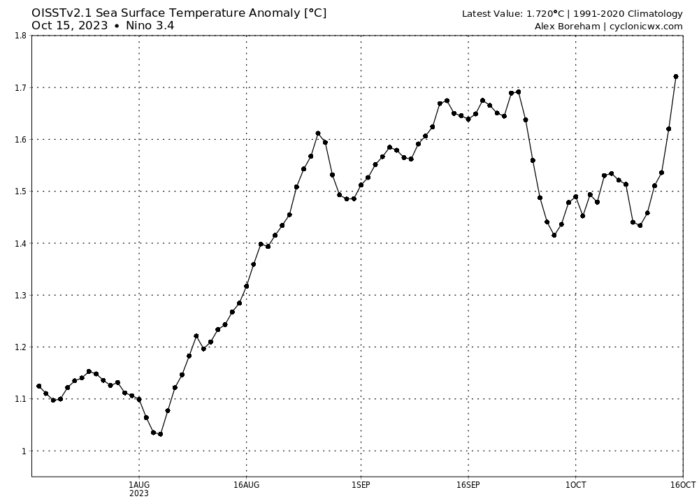
New 3.4 daily peak at +1.72
-
Low of 45
-
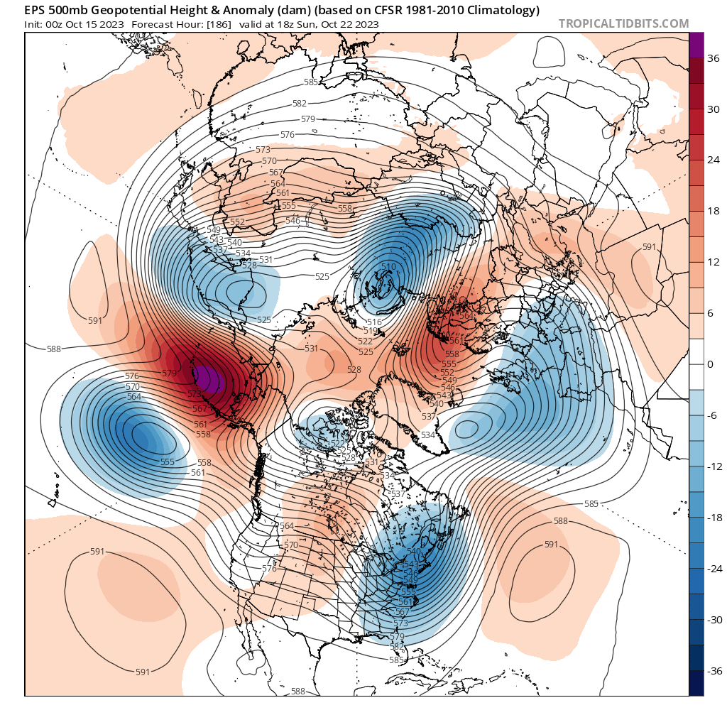
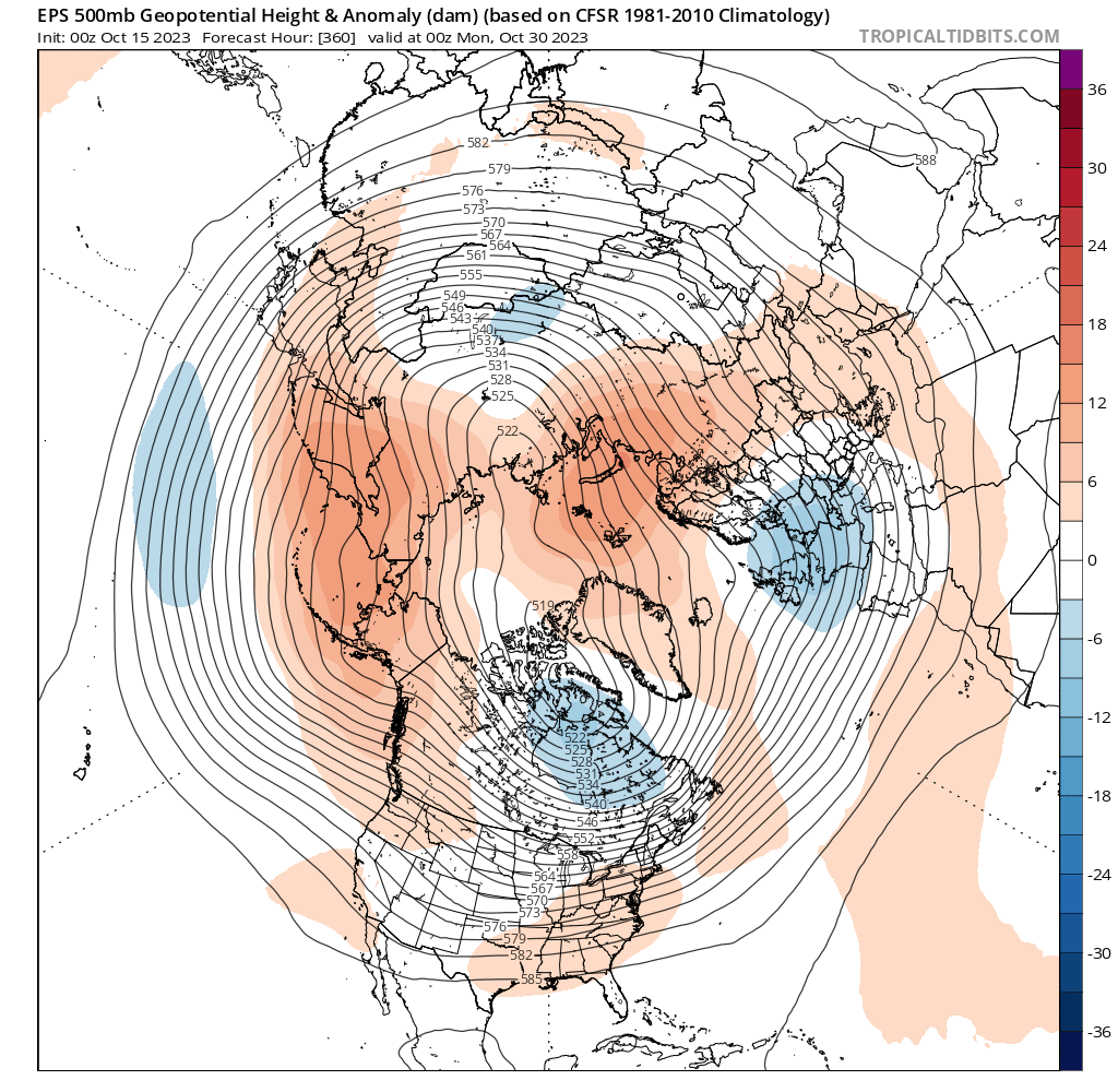
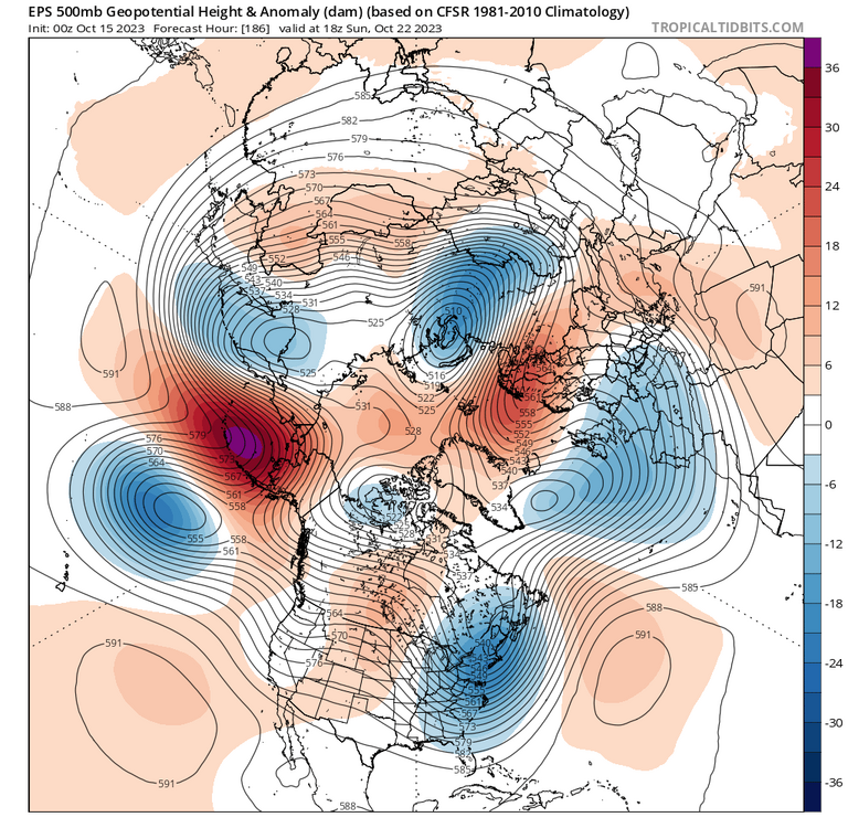
Ensembles showing a transitory -pna the last week of october, starting with a building ridge over aleutians/alaska. But what’s interesting is support for a rex block in the north pac, with a low/trough replacing that stubborn nina-like ridge north/NW of hawaii. Longer range shows additional ridging over the aleutians and west thereof, with continued troughing NW of hawaii. Will be interesting to see how the PDO evolves, and I’m thinking much less negative than it is now.

-
Thanks, it seems they use CDAS. The one I posted uses OISST, which I think is what is used officially.
-
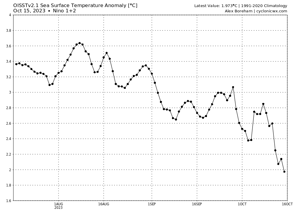
Daily 1+2 has fallen below 2.0c for the first time