

Terpeast
-
Posts
5,326 -
Joined
-
Last visited
Content Type
Profiles
Blogs
Forums
American Weather
Media Demo
Store
Gallery
Everything posted by Terpeast
-
Down to 33 already
-
Yeah, he always seemed to be playing from behind. I remember that during the Jan 1996 storm, we had about 20” on the ground and the snow lightened up in intensity. I was worried the storm was almost over, but Bob said “another 6-12 inches coming overnight”. Was doing the math in my head and thinking holy shit, I could get 30 inches!
- 1,295 replies
-
- 5
-

-
- wishcasting
- almost winter
- (and 1 more)
-
I preferred Doug Hill over Bob Ryan. Ryan used to always downplay big storms and completely whiffed on Jan 25, 2000… while Doug admitted on live TV that he was “suspicious” that models were wrong about it going OTS.
-
Terpeast's 2023-24 Winter Outlook - Overall Grade: C
Terpeast replied to Terpeast's topic in Mid Atlantic
Thanks MN. Yeah - I'm pretty bullish about our chances at reaching at least climo or above in our area. Still, a 10% chance is a non-zero chance. It can still happen. 1972-73 kept popping up in my analog research... -
That's also a reasonable guess and could very well be correct. I'm just a bit more bullish than your numbers for north of rt 29 and the I-95 corridor from DC to philly. And yes, we had a dry October after a very wet September. Also I don't think the STJ really kicks in until December anyway.
-
Terpeast's 2023-24 Winter Outlook - Overall Grade: C
Terpeast replied to Terpeast's topic in Mid Atlantic
One area, you mean within the MA forum? The mountains would be the easy answer. East of the blue ridge, I don't know. It's like trying to work out the exact location of mesoscale banding on a 384 hour storm this far out. We just have to see how the cookie crumbles... -
Can't wait to see yours!
-
Terpeast's 2023-24 Winter Outlook - Overall Grade: C
Terpeast replied to Terpeast's topic in Mid Atlantic
Glad you all enjoyed reading this. I wanted to make it easy to skim and digest, while being as comprehensive as possible. Now let’s see where the chips fall… -
I’m no expert on SSW events so I’d defer to @GaWx on this, but if this plays out as forecasted, this could be an interesting January for most of us up and down the EC.
-
28
-
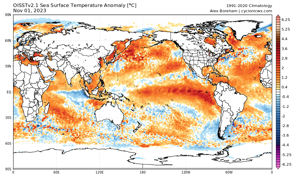
If you look at the aleutian low on cansips, you’ll notice how west-based it is. In my outlook I did note very warm nino 4 temps having the effect of pulling the aleutian low west.
-
As promised, here's my outlook:
- 1,295 replies
-
- 18
-
-

-
- wishcasting
- almost winter
- (and 1 more)
-
Alright, I did it. Here's my outlook.
-
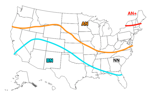
I put my outlook in a PDF, so I'll put the "tl,dr" here: There are a lot of mixed signals leading into this winter. But I have seen enough signs to raise my confidence for an interesting winter across the Mid-Atlantic and Southeast U.S. This year is the best chance for a big winter or a top 10 KU since 2015-16 or even 2009-10. However, I have also seen other signs that confound the potential for big snowfall, like Hunga Tonga, continuation of a negative PDO base state, and abnormally warm SSTs everywhere except for a few cool spots. I relied on factors such as the MEI, PDO, preceding Pacific "base state", AMO, QBO and solar cycle. Instead of giving one range for snowfall, I went with a probabilistic forecast instead. So for the mid-atlantic, here's what I think will happen: +2 degrees F above normal (medium confidence) 10-20% wetter than normal (high confidence) 60% chance we beat climo for snowfall (low-medium confidence) 15-30% chance we get a top 10 HECS Probabilistic snowfall forecast*: 0 to 10 inches: 10% chance 10 to 20 inches: 30% chance 20 to 40 inches: 45% chance 40” or more: 15% chance *if you're in the mountains, you can double or triple these numbers depending on your elevation/upslope activity and the same probabilities will apply And now the temp & precip DJF maps: You can read the attached PDF to see how I arrived at my outlook. Or you can just click here: https://drive.google.com/file/d/10gF1EktEgErvpJ_pIgmN-OTLpz0VRLRe/view?usp=sharing I don’t expect you to read the whole thing, so I created a linkable table of contents on the next page so you can jump to the parts that you care about. But I’d be ecstatic if you actually read the whole thing! Terpeast's 2023-24 Winter Outlook.pdf
- 27 replies
-
- 35
-
-
-
I would too. I was waiting for this in case I need to change my outlook. But no changes needed. I’ma post it as is
-
With aleutian troughing and western & arctic ridging, not much has changed. The general idea is pretty much the same
-
Yeah, it's the Canadian. Anyway, the 40% this 40% that doesn't really tell us much of anything. The 500mb maps tell a lot more. Are they usually this late in releasing those?
-
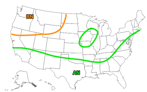
So for my area, basically a 40% chance of AN temps and 40% chance of AN precip. Warmer NE, and equal chances SE
-
Ok so what's going on with CANSIPS?
-
Now who's being reductive?
-
I want my money back!
-
Yeah, that might explain the two different NAO trends over different time frames. And thanks for raising the point about a cold blob, that would definitely play a role in strengthening the north Altantic jet. Right now, it seems to be there, if not a little displaced southward. Normally it should be NE of newfoundland expanding up towards near Iceland. But it looks south-ish with some noisy mix of gulfstream waters. Not sure what to make of it.
-
Yeah, food for thought. If it were ONLY due to CC, wouldn’t we have seen more summer -NAOs at the same time when we started seeing less -NAO nino winters around 1978-1980 instead of not manifesting until 2007? Hard to separate existing atlantic variability out from CC when it comes to the NAO, but I think it’s just part of it. The warm/rising AMO up-cycle has been going on 40 years now, and I think that has something to do with it.
-
Yeah, even when I was a kid reading LWX AFDs I remember how hard it was to get a -NAO before CC accelerated. But when it happened, it really delivered.
-
Not sure I buy it yet. I think a big part of it is a +NAO/atlantic decadal cycle and the La Nina base state since the 2016 super nino. Yes, the blocks have been south based, but that's happened plenty of times before. Maybe after we get a few more strong El Ninos and a couple of +PDO seasons, and we still don't get a deep -NAO despite having an -AO, then yeah I'd start buying into this theory.
