Terpeast
-
Posts
5,326 -
Joined
-
Last visited
Content Type
Profiles
Blogs
Forums
American Weather
Media Demo
Store
Gallery
Everything posted by Terpeast
-
Only made it to 76 before the clouds moved in from the NW, down to 71 now
-
Pretty consistent with my outlook
-
Yeah, I’m a bit concerned about the marine heat wave off Japan, but that’s not a PDO thing, something else is going on
-
And that’s not the worst thing. We (well, I) don’t want a super nino. It’s a hit vs miss gamble for one HECS, and if we whiff it’s yet another ratter. Besides the last 3 times we had a super nino, we had triple dip La Ninas right after. So I’m not rooting for a super, personally. And I agree with you that we don’t get there.
-
I just think it mostly means we’ve peaked. we’ll see about those wwbs east of the dateline starting nov 15, but hard to say if that will move the needle
-
Only made it to 61 today after hitting 77 yesterday
-
I don’t know about the NOAA data for real-time monitoring because it’s monthly and I would think there is some kind of lag. I mean if the big pdo rise is not showing in that dataset, it may either mean its a month behind or something isn’t right with their data
-
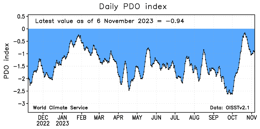
Time sensitive - WCS daily PDO holding at -0.88. Looking at the ensembles, I expect it to hold around there or touch -1 again, then rise after that.
-
Absolutely. It could swing the other way next month, or take its sweet time into getting above 0.5 till January. But then again, I expected it to come in at 0.75 this month and I was wrong. So...
-
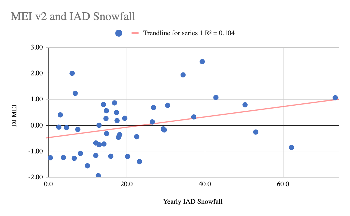
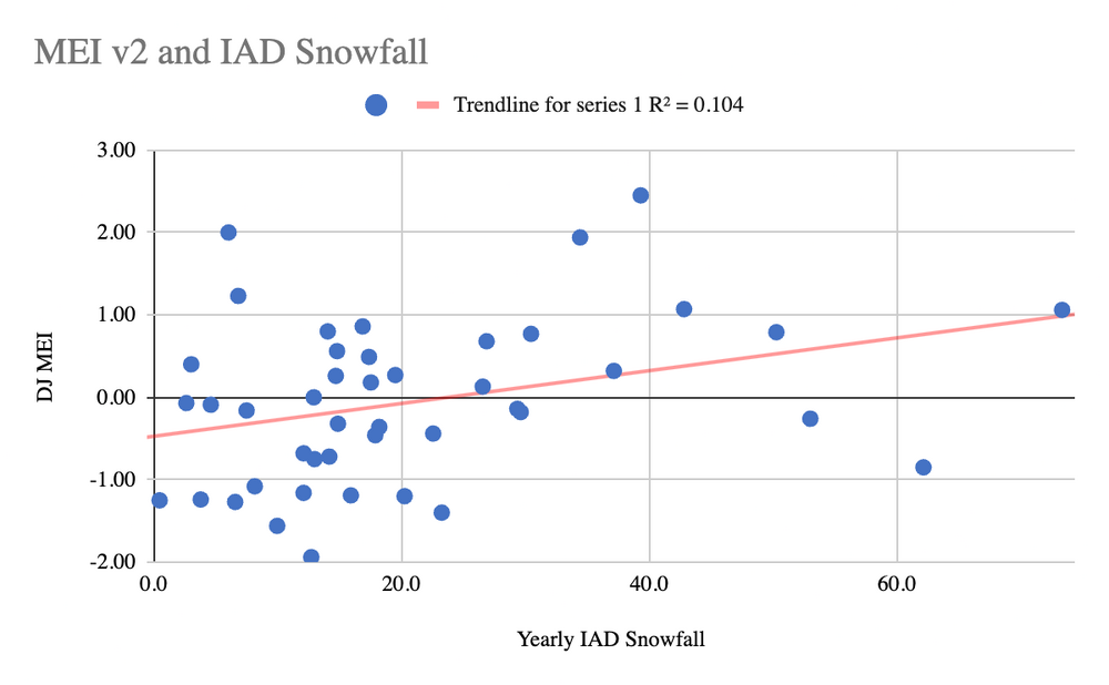
For KIAD, there is a weak positive correlation between snowfall and MEI. It's noisy and mostly a crapshoot, but we can clearly see a few things: - If the MEI is less than -1.0 (stronger Nina), it gets very difficult for us to reach climo or above. Most often we end up with less than climo. - If the MEI is greater than +1.0 (stronger Ninos), we likely get a warm winter overall and MAYBE with a HECS that pads snowfall totals. No HECS? Ratter. - If the MEI is between -1.0 and +1.0, it really can go either way. Notice that if we are between +0.5 and +1.2 (which I prefer using as the cut off), our chances for a colder and snowier winter go up. MEI +1.2 or higher: MEI between +0.5 and +1.2 So this recent drop in MEI probably precludes us from getting over +1.2, which may be a good thing in avoiding a mild winter for the CONUS, but I think we will need to get a more favorable nino profile in the pacific to get a colder winter than the last 8 years.
- 1,295 replies
-
- 14
-

-

-
- wishcasting
- almost winter
- (and 1 more)
-
Great job, I think we're tracking along the same lines for our outlooks. I have mby at 60% chance of above snowfall climo, so you're about 10% more bullish than I am
-
And he’s willing to discredit his own work in hopes of getting one. I’m thinking maybe I should have used RONI instead.
-
And it also came after a triple dip nina (kind of - 85-86 was cold neutral)
- 1,295 replies
-
- 5
-
-
- wishcasting
- almost winter
- (and 1 more)
-
Too soon, same thing happened in 1986-87. It’ll probably go back up in the next month, but if it doesn’t, then I’ll probably consider updating my outlook.
- 1,295 replies
-
- 1
-
-
- wishcasting
- almost winter
- (and 1 more)
-
It's going to be a noisy day tomorrow. Get ready... (I've already said my piece earlier today)
-
Sorry @GaWx This is what I used, not the other link. It was a pain to copy the color coded table into my own excel, though.
-
https://psl.noaa.gov/enso/mei.ext/table.ext.html Just note they don't match up well with the new v2 index though
-
Well, he's got a point right there.
-
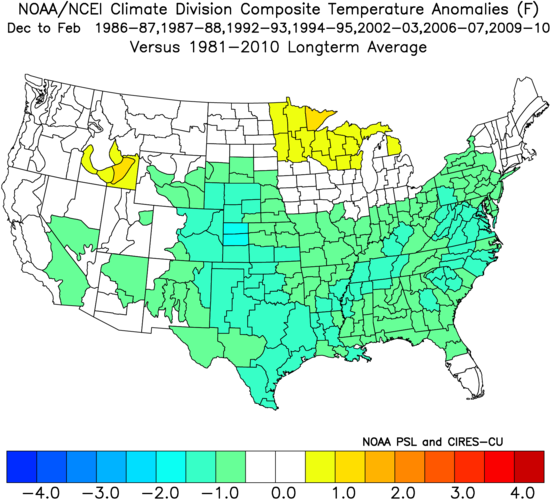
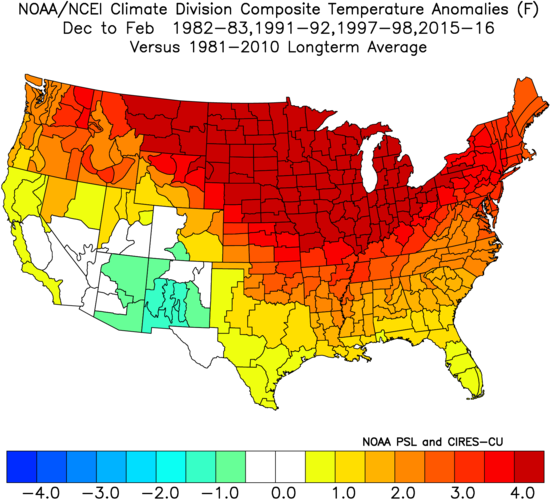
My research showed that we want to keep the MEI under 1.2. If it goes over 1.2, then we go warm everywhere except a small part of the SW. If it stays between 0.5 and 1.2, then we have a decent shot at a (relatively) colder winter and still have a decent STJ. If it stays under 0.5, then all bets are off. It could go either way.
-
I see that now, 1.4 to 0.6. Wow. So this isn’t exactly unprecedented.
-
It may be useful to explore why the MEI dropped. I don’t think the PDO is the reason since it came up in October and is only slightly/moderately negative compared to last month when the MEI came in at 0.6. Some would call it “nina background state”, but that’s too generic and almost useless. It could be the very warm Atlantic ssts or the strong IOD messing with the MEI, or something to do with OLR data. Not changing my outlook for now, but if it drops again or stays low in the December update, I may do that.
-
Well, I certainly did not expect the MEI to drop. It's what I based my outlook on, but with the assumption that MEI would stay between 0.5 and 1.2. Btw, same thing happened in 1987 with that year having an even bigger drop, with a recovery throughout the winter. So perhaps it gets back into the +0.5 range next month, so it's premature to change my outlook for now.
-
It's the best looking horse of the bunch now. Doesn't mean it's an A- or even a B+ match. Probably more like a B- match and the rest are C or D matches. Even back in September, when the PDO was like -3 and the very thing it would take to bring it to neutral would flood us with mild air almost through the entire autumn into early Dec, I knew there was going to be a lot of hand wringing and outright capitulations.
-
Wow, big change! Could mean it also went warmer, though?
-
Neg correlation in my map means lower height anomalies. Take the december map for example, we have neg correlations (lower heights) over Greenland. So the +NAO signature is still there ^^ @Stormchaserchuck1 beat me to it. And explained it more succinctly than I did.