

Terpeast
-
Posts
5,326 -
Joined
-
Last visited
Content Type
Profiles
Blogs
Forums
American Weather
Media Demo
Store
Gallery
Everything posted by Terpeast
-
54. Haven’t exceeded the midnight high so far
-
Lets hope for the GEM solution for Central-SW Virginia’s sake. Euro would be decent too
-
To counterbalance with the other side of this, I find that analog winters with an Aleutian low often have upstream ridging over Japan and just off their coast. I thought to myself that it’s not a bad thing to have if we want cold and snow in the east, as long we have a downstream trough off the aleutians.
-
We're already in mid-winter form. Canceling winter before it even starts. In a -PDO/+ENSO battle like this season, there's going to be a lot more of this. At least it won't be boring like last winter. Just look at the models... STJ is becoming more and more active.
- 1,295 replies
-
- 8
-

-
- wishcasting
- almost winter
- (and 1 more)
-
So I can book a family trip out west next winter without fear of missing a HECS
- 1,295 replies
-
- 2
-

-

-
- wishcasting
- almost winter
- (and 1 more)
-
If anything, the recent spike (was it really a spike, or some aberration with data?) will help shift us to an El Nino base state. Anything to wipe out the residual nina effects - and I think that will happen.
-
Actually, I’m thinking the peak was Oct-Nov. Either SON or OND on the trimonthlies. ^ @GaWx beat me to it.
-
I’m calling it. This nino has already peaked. It’s time to start tracking h5 and individual waves!
-
Haven’t noticed any smoke here. Bottomed out at 32, but already up to 54 now
-
Anyone have a clue why OISST hasn’t updated on cyclonicwx?
-
That EPO spire is really going to give a -PDO a kick in the rear
- 1,295 replies
-
- 6
-
-
- wishcasting
- almost winter
- (and 1 more)
-
Yeah I get that, but you kinda walked into it
-
Yep, and lets get psuhoffman on the board so we can have a blockbuster this year
-
I hope you're right @psuhoffman! You're a bit more bullish than I am, tbh. I hedged a bit downward because I think we'll see some SW troughing episodes (pac base state) that'll "steal" a couple of our chances. Also, one thing I did differently was to include 57-58 and 65-66 (as well as 76-77) but by warming them up a few degrees and thus reducing their snowfall totals, and that dragged down my overall snowfall prediction for the area. But I understand your trepidation and I have the same thing, especially after the recent MEI value came in way low. Agreed that it's good we're not going super nino, though.
-
I asked him that yesterday and he said it was too warm to amount more than maybe a trace
- 1,295 replies
-
- 1
-

-
- wishcasting
- almost winter
- (and 1 more)
-
Following is +0.5 IOD on a 4 month lag before DJF for all years since 1960 regardless of ENSO. Same, but only for El Nino winters (only eliminated a couple of enso neutral years): BTW, this uses the DMI index. Not sure if that makes a difference.
-
Got access? Or still experimental?
-
Yeah if that new wwb holds east of the dateline we MAY get to 1.7 trimonthly
-
When we get the peak trimonthly average, we will likely see SON or maybe OND at 1.6. I’m calling this a moderate nino considering other competing factors.
-
Note most of those years listed above are el nino years. And this year we also have a neg QBO. So as hard as it's been to have a sustained -NAO winter, maybe this is the year we finally get one.
-
I noticed that blocking signal, too and addressed it in my outlook. I don’t know why we get a stronger signal on the atlantic side as a result of that -pdo/+enso pac combination, but it is there. And combine that with a -qbo.
- 1,295 replies
-
- 6
-
-
- wishcasting
- almost winter
- (and 1 more)
-
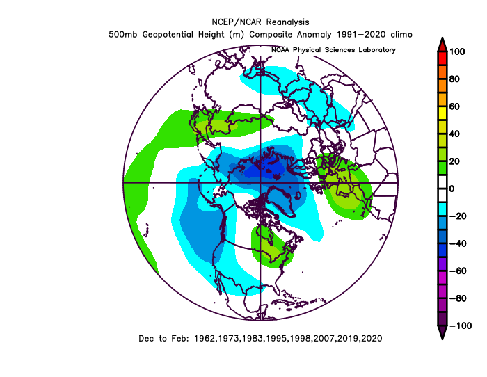
To add, here’s @griteater’s excellent -pdo/+enso analysis. You’ll like this.
- 1,295 replies
-
- 4
-
-
-
-
- wishcasting
- almost winter
- (and 1 more)
-
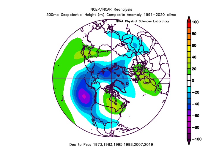
I’ll say this about the ongoing battle between -pdo and +enso… If the -pdo wants to throw up an aleutian ridge, we might see it keep getting amped and pushed east by aleutian lows. Then we may keep getting looks like this.
- 1,295 replies
-
- 5
-
-
- wishcasting
- almost winter
- (and 1 more)
-
High of 55 today
-
Yeah, we just need to give psuhoffman an inch to get him to put down the logbook.
- 1,295 replies
-
- 4
-
-
-
- wishcasting
- almost winter
- (and 1 more)