Terpeast
-
Posts
5,326 -
Joined
-
Last visited
Content Type
Profiles
Blogs
Forums
American Weather
Media Demo
Store
Gallery
Everything posted by Terpeast
-
It looks better after the 4th so far (the cold air)
-
Yeah, 2 runs in a row of this, and I’m starting to think that we’re paying the price of the canadian torch. Onto the next one.
-
The BL got even warmer this run, while 850s got colder
-
534 line way north, though. No dice
-
12z a bit south, 850s bit cooler. BL still torched on the onset. We’ll see if it helps the backend
-
Everyone in the NYC forum and many in the MA and NE forums are starting to do the same
-
To lighten up the mood with a non-serious comment... that same run does drop a couple inches of slush imby. Snowshoe gets 2 ft+ Chase anyone?
-
Ignoring the surface panel for a second - The 850 low tracks just underneath us. 700 mb low right overhead or just underneath if you’re north of DCA. thicknesses are 534-540 This is a mostly snow look. It may indeed start out as rain initially as there’s a trowal with ~0 air at 850 and a warmer BL, but with heavier rates on the backside with a north wind, that’s going to be snow. I think the surface depiction of ptypes are wrong. At least 50% wrong on the backside.
-
Rain, 43
-
Unremarkable xmas weather, high of 55 and now down to 41. Cloudy. At least it’s not a 70 degree torchmas
-
That was close.
-
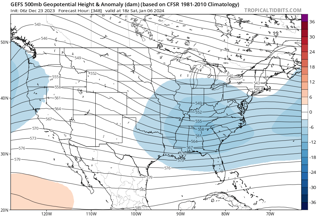
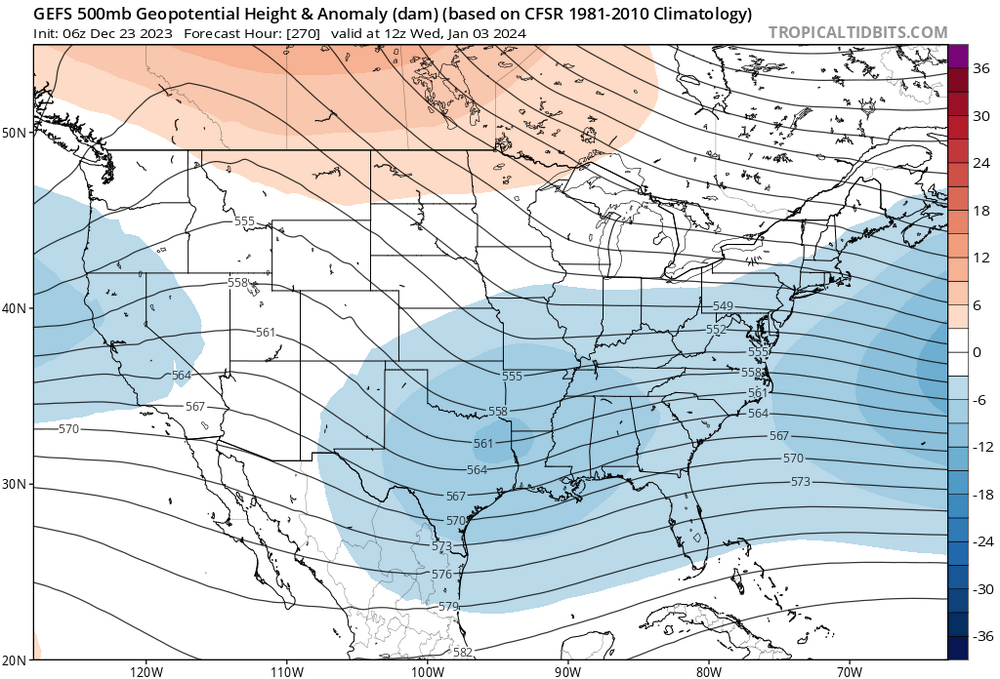
FWIW 12z op gfs shows a bomb off the coast Jan 3. BL a tad too warm verbatim, but it’s very close. Jan 5-6 wave a bit weaker, but with better cold air. I think I’d rather have it switch places. Weaker wave with marginal air, then bombs away on Jan 5. Usual disclaimer: it’s the op gfs so this analysis is mostly just for fun
-
This morning’s ensembles show something on Jan 4-6, something coming off the gulf with cold-enough temps. Still a long ways away, lets see if that potential holds. Btw, Merry Christmas to those who celebrate! Happy Holidays all!
-
At least its not teasing us with 10-15” or 50%+ chance of 3”+ on day 15 like it did all winter last year
-
That’s what I think, we (not just us but everyone) get a CC penalty against our overall snow. For now I think its somewhere around 15-20% but may grow bigger. I’m not changing my outlook, but if we end up getting nothing from the Jan 1-10 window of opportunity, then I think my 15% chance of a blockbuster season is off the table. Still have a shot at above climo. Impressive signal of SSWE on all models, so things could get fun mid-Jan onwards
-
I suspect gfs is too warm at the surface for Jan 2, euro is colder. But too far out for these details. Still keeping an eye on
-
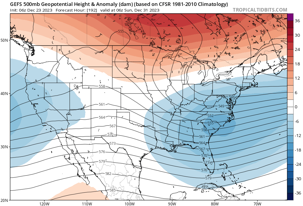
CMC is following gfs trend for Jan 1…
-
Good post. I’m not overly concerned with temps up there even if they are record levels. Just a small change in the ridge orientation will bring cold (yes, even modified cp airmass is cold enough for snow in the MA). Snowcover will improve drastically across the northern half of the CONUS with the xmas cutter, too. Then we flip colder on around the 29th, then game on.
-
I see 3 possibilities between Jan 1 and Jan 8. The first is a long shot because it’s suppressed and OTS at this moment, but still time for it to change. Recent gfs run trended closer to the coast actually. If we could get better spacing vs the storm before it, it might actually turn into something. Second is Jan 3-4, a weak slider (you can see it on the mslp anomaly panel on the ensembles). Third is Jan 6-8, a more sig wave that Bob Chill was talking about wrt gulf moisture feed. It’s also on the mslp anomaly panel. Those are the 3 to watch.


-
Had him on ignore so I had to manually show his post to see what the context was. Looks like I missed the whole “party” lol
-
Good recall. They’re trying to have it both ways
-
Yeah they’re saying that models will correct warmer as polar air modifies moving south. That may be true, but the models are already accounting for that and we don’t need it colder than “cold enough” else we risk suppression.
-
And don’t sleep on the low op runs are trying to develop on Jan 1. For now its too far SE by 200 miles, but that kind of range is nothing for a D9 threat
-
The turn to colder temps is still on the 28-29th, all ensembles support this. That has remained unchanged for some time
-
Pass. I’m not a fan of mixed events. Give me a clean snow event and I’m happy. Even if it’s just a couple of inches. But if it’s a midwest low with a front end thump to dry slot with minor mixing, that’s pretty acceptable to me.