Terpeast
-
Posts
5,326 -
Joined
-
Last visited
Content Type
Profiles
Blogs
Forums
American Weather
Media Demo
Store
Gallery
Everything posted by Terpeast
-
Jan Medium/Long Range Disco: Winter is coming
Terpeast replied to stormtracker's topic in Mid Atlantic
Gfs may have overcorrected with the SE trend (or it may be onto something) We have a little more wiggle room with cold air and the r/s/mix line, and that’s what we can say at this point. No complaints ( except maybe the Canadian) -
Jan Medium/Long Range Disco: Winter is coming
Terpeast replied to stormtracker's topic in Mid Atlantic
We need it. D5-6 is when models take a hop SE, then trend north as lead times continue to shorten. So that’s one thing we got to watch out for. But we do have things going against the last minute north trend - stronger confluence and better cold air. And the 1/4 lead wave never trended north, it just continued to weaken and trend south from D7 to D3, and I don’t see it changing much from here on out. -
Jan Medium/Long Range Disco: Winter is coming
Terpeast replied to stormtracker's topic in Mid Atlantic
These colder and SE trends are exactly what I hoped to see. Still time though. Lead 1/4 sw just now coming onshore in SoCal, so maybe the newer runs have better data? and Happy New Year! -
Jan Medium/Long Range Disco: Winter is coming
Terpeast replied to stormtracker's topic in Mid Atlantic
Tiny changes, r/s line wiggled a few miles southeast. Could be all it takes for this one! verbatim this looks like a pastebomb -
Jan Medium/Long Range Disco: Winter is coming
Terpeast replied to stormtracker's topic in Mid Atlantic
Jan 96 is my #1. According to obs from others I should have seen sleet or at least dry slotted, but I never saw a pellet and snizzled all through the slot which lasted only a couple of hours, then it cranked up again all night and all morning with legit blizzard conditions. Also the coldest storm I’ve seen, and call me crazy I preferred it over the 2009-10 storms. I was upset that not only DCA but also IAD lowballed their totals in that storm because I got significantly more and wanted that on official record -
Jan Medium/Long Range Disco: Winter is coming
Terpeast replied to stormtracker's topic in Mid Atlantic
At the risk of making a “water is wet” statement, I remember it being much colder, too. I have fond memories of the back to back 87 storms. -
Jan Medium/Long Range Disco: Winter is coming
Terpeast replied to stormtracker's topic in Mid Atlantic
Am with you on this. I’m surprised at the pushback as well, and pleasantly so at the guidance trends yesterday. We’re forgetting that 1/7 was depicted as a rainstorm with the 0 line all the way to the great lakes. This has indeed trended colder, and I’m hoping this trend continues. -
Jan Medium/Long Range Disco: Winter is coming
Terpeast replied to stormtracker's topic in Mid Atlantic
I was too little to remember much of it, but my mom STILL talks about it to this day, and she’s lived through all the blizzards here including from 79 through 16. I think 83 was her favorite and still has pics of it. -
Jan Medium/Long Range Disco: Winter is coming
Terpeast replied to stormtracker's topic in Mid Atlantic
And interesting to see a more pos tilt on that wave. As long as it doesn’t close off, it might delay the turn up north and keep i-95 in the game. Usually these things trend the other way -
Jan Medium/Long Range Disco: Winter is coming
Terpeast replied to stormtracker's topic in Mid Atlantic
Yeah, that first system is just off CA about to enter the conus. I don’t know if sampling is a thing anymore like it was 10-15 years ago, but I think @Eskimo Joe mentioned it a page or two back -
Jan Medium/Long Range Disco: Winter is coming
Terpeast replied to stormtracker's topic in Mid Atlantic
Just one run but with that gradient through my house… my front yard facing NW might get more snow than my rear yard -
Jan Medium/Long Range Disco: Winter is coming
Terpeast replied to stormtracker's topic in Mid Atlantic
Euro was all rain east of 81 at 0z and before that, so even 12z while not ideal is a reverse trend vs the gfs -
Jan Medium/Long Range Disco: Winter is coming
Terpeast replied to stormtracker's topic in Mid Atlantic
Gotcha, thanks! -
Jan Medium/Long Range Disco: Winter is coming
Terpeast replied to stormtracker's topic in Mid Atlantic
Any notable trends on the euro? -
Jan Medium/Long Range Disco: Winter is coming
Terpeast replied to stormtracker's topic in Mid Atlantic
From last night’s runs, I assume. It’s trended colder from 4+ days ago when it was depicted as all rain. So the actual verification might be somewhere in the middle. Too early to tell, but I’m not sold on this being a mostly snow event here. We don’t even have the first wave passing us yet, and that will partly determine the cold air setup here. -
Jan Medium/Long Range Disco: Winter is coming
Terpeast replied to stormtracker's topic in Mid Atlantic
I’ll say this. Even if this particular event doesn’t pan out as an i-95 special, this should give us reason to feel good about the rest of the winter. The STJ is relentless and unloading its ammo with no end in sight. All we need is to get more cold air on top of us. And 1-2 moderate/big hits is all we need to reach climo, plus another hit to get above. -
Jan Medium/Long Range Disco: Winter is coming
Terpeast replied to stormtracker's topic in Mid Atlantic
December has never been a big winter month for me growing up here. 2002-2010 was a massive fluke for Dec. Also the cryosphere delays the cold in the beginning while extending it at the end of met winter. -
Jan Medium/Long Range Disco: Winter is coming
Terpeast replied to stormtracker's topic in Mid Atlantic
Also, noticed that the system is slower with less NS interaction. We want it to speed up a bit to catch the best cold air.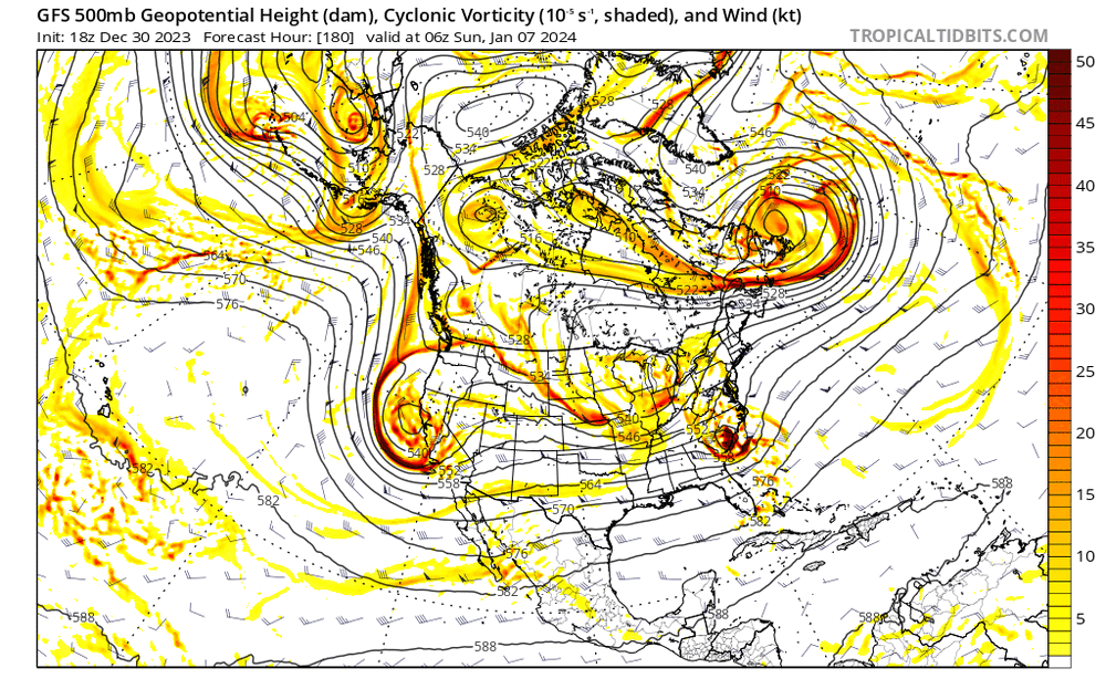
-
Jan Medium/Long Range Disco: Winter is coming
Terpeast replied to stormtracker's topic in Mid Atlantic
Maybe it’s different during a nino, but last year the ensembles had tracks biased too far SE at 5-8 day leads. They eventually corrected to the op tracks. We saw the ens move NW with the mean track already. The op is too far NW for a pure snow event along I-95, but NW of the fall line still in the game. Let’s root for the 1/4 system to go ape off the coast for a stronger 50/50 -
Jan Medium/Long Range Disco: Winter is coming
Terpeast replied to stormtracker's topic in Mid Atlantic
LWX AFD on the 1/4 system - not buying into a phased scenario. Maybe this just helps set us up for the next system The aforementioned shortwave over the Great Lakes will continue to dig southeastward on Thursday. Model guidance varies quite a bit with respect to the amplitude of this feature, and how it interacts with a southern stream disturbance located over the southeastern US. Solutions vary from the northern stream staying lower amplitude/to our north and not having any interaction at all with the southern stream disturbance, to becoming higher amplitude in nature, and coming close to phasing with the southern stream system. Probabilities from ensemble guidance favor a non-phasing scenario, with a weaker northern stream disturbance progressing nearby or overhead. This would yield some low end chances for a few rain or snow showers on Thursday, with most of the area remaining dry. If the systems were to phase, there could be a stronger coastal storm, but most solutions that have that scenario playing out, have it occurring further offshore. In either scenario, the northern stream system will drive a cold front through the area, potentially leading to some upslope snow Thursday night, and colder temperatures on Friday. -
Jan Medium/Long Range Disco: Winter is coming
Terpeast replied to stormtracker's topic in Mid Atlantic
Yep, lets see if they converge on that. Probably wiggle waffle for a few days and then hone in at d4-5 -
Jan Medium/Long Range Disco: Winter is coming
Terpeast replied to stormtracker's topic in Mid Atlantic
Yeah, well I hope the gfs is right about having a cold high to the north -
Jan Medium/Long Range Disco: Winter is coming
Terpeast replied to stormtracker's topic in Mid Atlantic
How are the thermals? I don't see much of a HP up north on that panel, so that strong of a signal makes me nervous about it being to warm for us (outside of the mountains) -
Jan Medium/Long Range Disco: Winter is coming
Terpeast replied to stormtracker's topic in Mid Atlantic
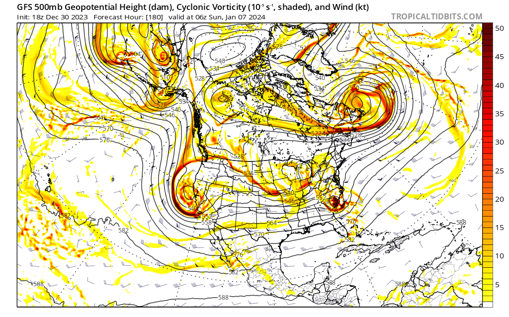
Same page. I've been harping on having a vortex at the tip of the Aleutians instead of a ridge or a GOA low for months now. This is based on my MEI research, where the MEI stays below 1.2 we have a weaker Aleutian low further west compared to a strong GOA low with MEI above 1.2. This past December acted as if the MEI was above 1.2 with a GOA low with pac puke, and the horrible model runs yesterday "overcorrected" that with a nina-like aleutian ridge. Now it seems to be swinging back into the middle like a pendulum. We shall see if that "middle" is the true middle that we want, and if that does verify. -
Jan Medium/Long Range Disco: Winter is coming
Terpeast replied to stormtracker's topic in Mid Atlantic
Gefs says 1/4-5 is the stronger system, but suppressed. Trended colder on 1/7 though. Remember when both systems were depicted to be too warm to snow not too long ago though