Terpeast
-
Posts
5,326 -
Joined
-
Last visited
Content Type
Profiles
Blogs
Forums
American Weather
Media Demo
Store
Gallery
Everything posted by Terpeast
-
Jan Medium/Long Range Disco: Winter is coming
Terpeast replied to stormtracker's topic in Mid Atlantic
I see two competing influences where this storm wants to come north, but at the same time the cold high gets even stronger while bearing down on us. Will be interesting to see how these trend until we're 60-72 hours from game time. By then, the models should be pretty locked in, give or take 15-20 miles -
Jan Medium/Long Range Disco: Winter is coming
Terpeast replied to stormtracker's topic in Mid Atlantic
Makes me think that storms will try to follow that baroclinic zone off the VA/NC coast NE-ward (if you've been paying attention to SST and t2m maps in that area, you know what I'm talking about) -
Jan Medium/Long Range Disco: Winter is coming
Terpeast replied to stormtracker's topic in Mid Atlantic
op GFS and GEFS very close in SLP placement at h132 -
Jan Medium/Long Range Disco: Winter is coming
Terpeast replied to stormtracker's topic in Mid Atlantic
I think a faster jump to the coast actually helps us -
Jan Medium/Long Range Disco: Winter is coming
Terpeast replied to stormtracker's topic in Mid Atlantic
Me too. We have so little wiggle room and we can't afford a slight north jog. 18z gfs just gave us a bit more breathing room -
Jan Medium/Long Range Disco: Winter is coming
Terpeast replied to stormtracker's topic in Mid Atlantic
-
Jan Medium/Long Range Disco: Winter is coming
Terpeast replied to stormtracker's topic in Mid Atlantic
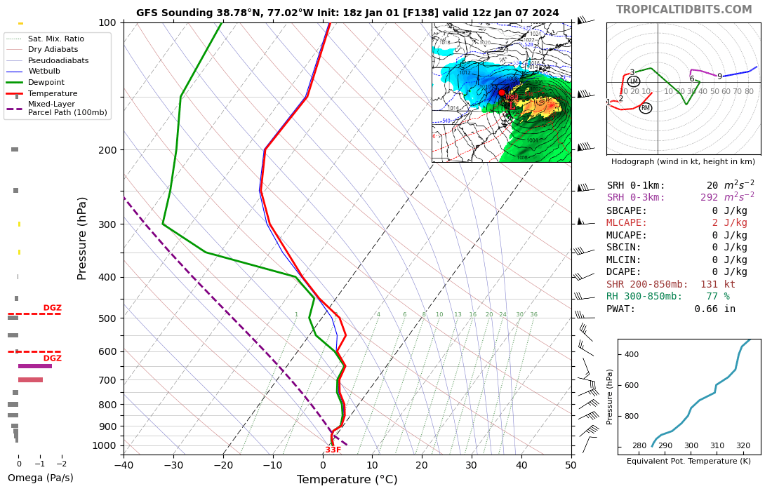
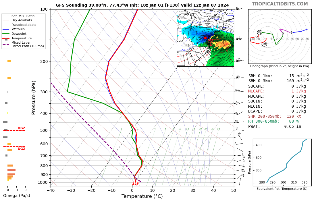
For fun - 138h sounding at KIAD in the middle of the storm
-
Jan Medium/Long Range Disco: Winter is coming
Terpeast replied to stormtracker's topic in Mid Atlantic
Cold high location exactly the same the last 3 runs, remarkable consistency -
Jan Medium/Long Range Disco: Winter is coming
Terpeast replied to stormtracker's topic in Mid Atlantic
Wowwww -
Jan Medium/Long Range Disco: Winter is coming
Terpeast replied to stormtracker's topic in Mid Atlantic
Fall line gonna be close -
Jan Medium/Long Range Disco: Winter is coming
Terpeast replied to stormtracker's topic in Mid Atlantic
I was telling psuhoffman the other day that if we got to January 1 and there was nothing noteworthy as a threat in the next 15 days, I would downgrade my snowfall forecast for the entire area by about 25%. Here we are, it's Jan 1 and we're tracking a threat that just might pan out for us. Not planning on any changes to my outlook until after the 1/7 event passes, then I will reassess from there. Downgrade may still happen if we go all rain in the low lands, which is not off the table yet. -
Jan Medium/Long Range Disco: Winter is coming
Terpeast replied to stormtracker's topic in Mid Atlantic
Interesting. So how do we use that information when comparing the GEFS with op GFS and other models? Is the GEFS better at shorter lead times and less so at longer lead times (10-15+ days)? Or if the op GFS takes a different track than the GEFS mean, do we lean more on the op GFS? -
Jan Medium/Long Range Disco: Winter is coming
Terpeast replied to stormtracker's topic in Mid Atlantic
Wait, is that really true?! -
Light rain now
-
Jan Medium/Long Range Disco: Winter is coming
Terpeast replied to stormtracker's topic in Mid Atlantic
Agree. The panel brooklyn posted would be the likely cutter that sets up the 50 low under the block and the next wave could undercut the TPV. It’s a great setup. Loaded with potential What’s more, the 50/50 would also help sustain the block long enough for the potential to play out -
I’ll record a trace as well
-
Jan Medium/Long Range Disco: Winter is coming
Terpeast replied to stormtracker's topic in Mid Atlantic
Oof. My TT still hasn’t updated -
Jan Medium/Long Range Disco: Winter is coming
Terpeast replied to stormtracker's topic in Mid Atlantic
SLP track similar to 0z eps, except surface high is stronger on 12z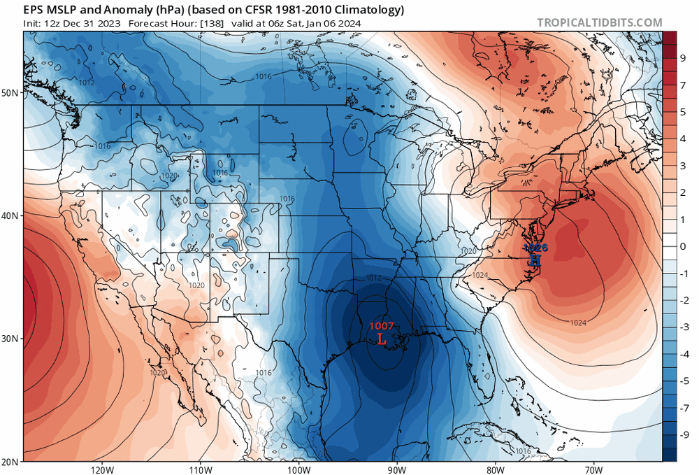
-
Jan Medium/Long Range Disco: Winter is coming
Terpeast replied to stormtracker's topic in Mid Atlantic
Better agreement with the op euro, at least with the fall line -
Bout of legit light snow
-
White flakes sticking on deck furniture. Is that enough to count as a T?
-
Jan Medium/Long Range Disco: Winter is coming
Terpeast replied to stormtracker's topic in Mid Atlantic
Note the trend of the cold HP strength up top on the gefs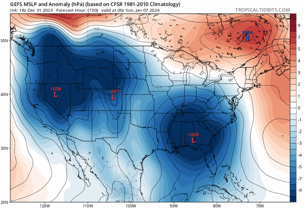
-
Jan Medium/Long Range Disco: Winter is coming
Terpeast replied to stormtracker's topic in Mid Atlantic
I have to say the models did an excellent job with today’s passage of the 1/1 system. They locked into it more than a week ago. Let’s hope this accuracy holds. -
Very very light snow falling. Ashburn
-
Jan Medium/Long Range Disco: Winter is coming
Terpeast replied to stormtracker's topic in Mid Atlantic
Have to agree with WxUSAF. This doesn’t quite have the markings of a 96/10/16 style HECS, but could still be a significant event for NW of the fall line. Max upside is around a foot for the lower elevs but with temp/ptype issues, the reality may be half that even with a favorable track. ETA: WPC seems more bullish though, so we shall see