

Terpeast
-
Posts
5,326 -
Joined
-
Last visited
Content Type
Profiles
Blogs
Forums
American Weather
Media Demo
Store
Gallery
Everything posted by Terpeast
-
Great analysis, and that's what changed in the last couple of cycles.
-
I don't usually go into the panic room, but... *sigh* Oh well, back to work
-
I-95 west is not out of the game yet. Maybe we won't get an all-snow event, but we'll see how the mesos handle the thermals going in. A lot of the time, they bleed colder than the globals the closer the event gets.
-
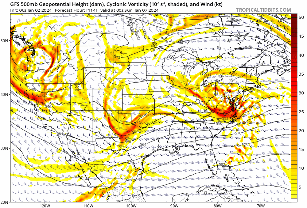
How the models shifted on H5 GFS: GEM: The Euro had an opposite shift from yesterday's 12z to today's 0z. I'll let you guys make your own interpretations.
-
Oh I wasn't even looking at the snow maps. I was looking at h5 and slp tracks
-
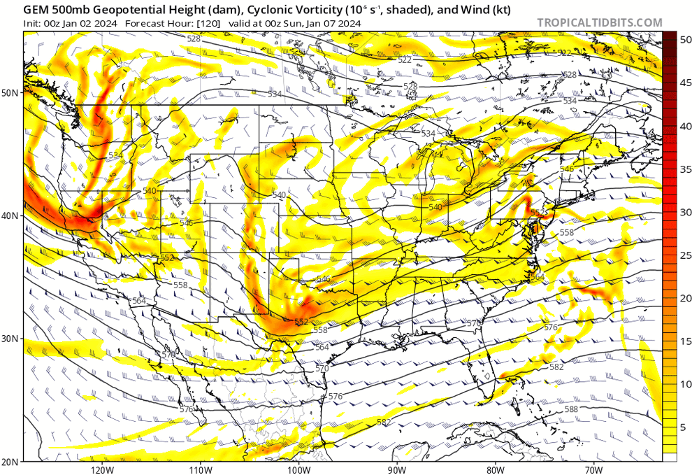
If you must look at the ICON, 12z is almost identical to 0z.
-
I love Spain. Where did you go? I've been to Seville and Bilbao. Both cities are a total contrast from each other, really interesting. And during the afternoon siestas, entire cities go really quiet and almost nothing is open. When I was at the Madrid airport about to leave, it started snowing. It was March.
-
In case anyone was wondering where I stand, that's all I was saying. Temper our expectations. Even the smallest trend one way or another can result in a drastic change in the outcome close to the fall line. Closer to I-81 will probably be fine and more immune to these shifts.
-
Yeah, when I was looking at the 50/50, there isn’t enough of a block to hold it in place. What we DO have going for us is timing. Faster storm, most precip happens at night, and with the in situ airmass like you said, we may still thread the needle to get at least a few inches east of the blue ridge. Which would be a win in early Jan during a nino. And I wouldn’t also count out the back end precip as the low departs.
-
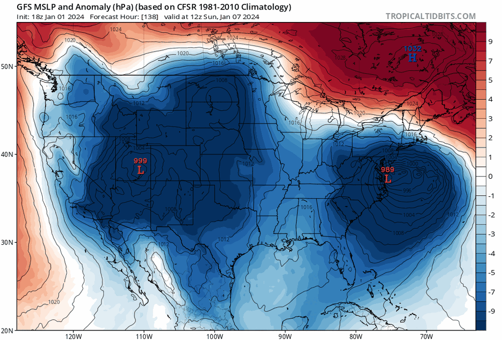
Even on the GFS I see a trend towards a weaker and further east 50/50 low, thanks to the wednesday system being less amped off the coast. I’m trying to be positive, but the gfs seems to be hanging on by a thread thanks to that stout 1031 high to the north despite less cold air. Continue that trend, and this thing may slip away from us. Let’s hope things get colder in 96-48 hr lead times
-
Or maybe its just a bad off run. Didn’t 0z euro trend better for i-95?
-
Can’t remember which model, but I picked up on weaker confluence last night. Euro 6z seems to be continuing that trend, while gfs is doing the opposite. We’ll have to see who is right about the confluence up north.
-
Jan Medium/Long Range Disco: Winter is coming
Terpeast replied to stormtracker's topic in Mid Atlantic
0z GEFS held serve -
Jan Medium/Long Range Disco: Winter is coming
Terpeast replied to stormtracker's topic in Mid Atlantic
No high to the north at all. That would probably be the worst case scenario -
Jan Medium/Long Range Disco: Winter is coming
Terpeast replied to stormtracker's topic in Mid Atlantic
Also more spacing. I think this event gained almost a full day from when we started tracking. Models have it starting around 1-3 pm saturday So by 18z tomorrow, we’ll be tracking an event at inside 96 hours -
Jan Medium/Long Range Disco: Winter is coming
Terpeast replied to stormtracker's topic in Mid Atlantic
Confluence a bit weaker, which is why the r/s line moved north. But there are also timing differences, and more spacing between the western vort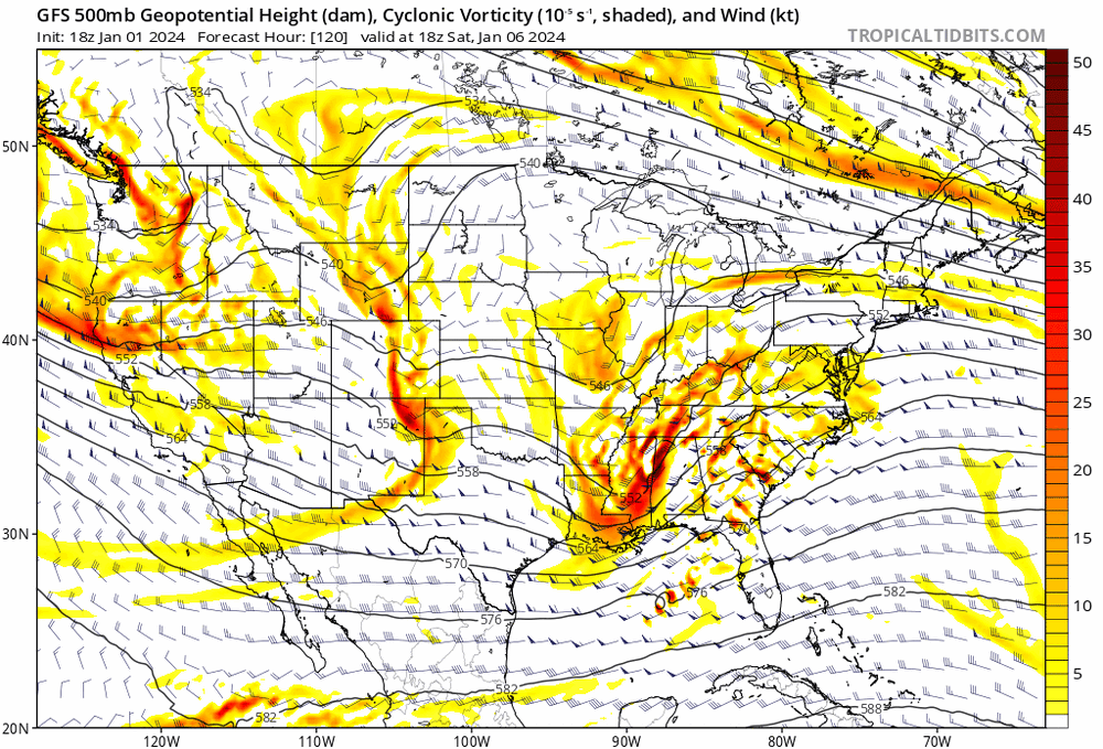
-
Jan Medium/Long Range Disco: Winter is coming
Terpeast replied to stormtracker's topic in Mid Atlantic
Although the SE Canada high retreated NE a bit, allowing the warm nose a bit north, note the second H north of MN. That’s new - wasn’t there before. Could be a new trend with better backside snows. Or it could be a blip?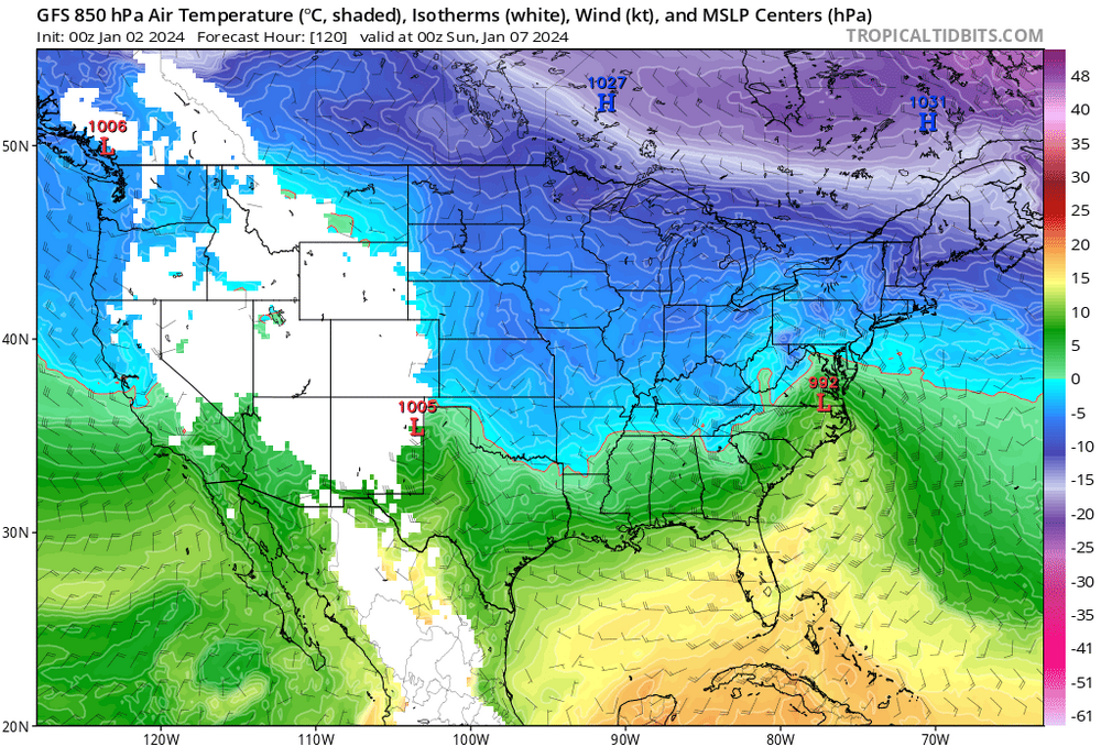
-
Jan Medium/Long Range Disco: Winter is coming
Terpeast replied to stormtracker's topic in Mid Atlantic
Icon also speeding up the storm, as has the other models. the speed up trend is for real -
Jan Medium/Long Range Disco: Winter is coming
Terpeast replied to stormtracker's topic in Mid Atlantic
I’ve only seen measureable snow twice and both were half an inch or less. Leesburg or west of 15 is probably better than Ashburn, but coming from Vienna, Ashburn probably will do better in i-95 fall line setups like this one -
Jan Medium/Long Range Disco: Winter is coming
Terpeast replied to stormtracker's topic in Mid Atlantic
Awesome, thanks for putting that together. If this does verify, its going to be a nailbiter out here. -
Jan Medium/Long Range Disco: Winter is coming
Terpeast replied to stormtracker's topic in Mid Atlantic
Not sure it’s necessarily trending warmer, but rather just moving things faster -
Jan Medium/Long Range Disco: Winter is coming
Terpeast replied to stormtracker's topic in Mid Atlantic
I don’t love that 0c line running over my house, but I’m more interested in the trend -
Jan Medium/Long Range Disco: Winter is coming
Terpeast replied to stormtracker's topic in Mid Atlantic
Still 5 days out. Let’s hope this holds serve at least. -
Jan Medium/Long Range Disco: Winter is coming
Terpeast replied to stormtracker's topic in Mid Atlantic
We've been looking at how this is trending, too. It has trended colder with a stronger high up north. I've been harping on this for 2 days now. -
Jan Medium/Long Range Disco: Winter is coming
Terpeast replied to stormtracker's topic in Mid Atlantic
I'm 80-90% confident that there will be a steep gradient in snowfall within a 20 mile range, or even less. I just hope most of us will be on the left side of it.


