

Calderon
-
Posts
1,133 -
Joined
-
Last visited
Content Type
Profiles
Blogs
Forums
American Weather
Media Demo
Store
Gallery
Posts posted by Calderon
-
-
25 minutes ago, Chinook said:
heavy damage reported at Idabel, Oklahoma from a couple of hours ago.
Unconfirmed reports of fatalities as well. Honestly not surprising if they come true.
-
Should cross I-30 at the big interchange just west of town with US Hwy 82. Two truck stops on either side of I-30 and a subdivision just south of them.
-
2 minutes ago, MUWX said:
I’m stunned this isn’t TORE
Just upgraded
-
Destructive tornado headed right at New Boston, TX.
-
This is why we need a doppler stationed in Hugo, OK.
Side note, Broken Bow was the sight of a F5 in 1982 in the saem county.
-
 2
2
-
-
9 minutes ago, Chinook said:
large tornado debris signature at Bagwell, TX
Confirmed huge wedge
-
Should stay northwest of Sulphur Springs proper. Not much north of I-20 except widely scattered homes.
-
Multiple towers cranes collapsed across the street from the infamous Charley gas station in the community called Charlotte Harbor on the other side of the harbor bridge form Punta Gorda.
.-
5
-
-
Tornadic waterspout likely.

I’d venture that’s a easy guess there. Helluva couplet.
Sent from my iPad using Tapatalk-
2
-
-
At this point it's almost safe to say it isn't "if" Tampa Bay gets storm surge but "how much" and for "how long".
-
1
-
-
1 hour ago, NJwx85 said:
Hearing unconfirmed rumors that they have started issuing evacuation orders for portions of Tampa area.
No rumor, it's for Hillsborough County Zone A.
-
Major comms issue with FTW has OHX (Nashville) issuing the warnings for their CWA. Trying to look at stream gauges as well and nothing has updated since at least midnight-1am.
-
10 hours ago, Hoosier said:
To steal a line from a poster of yesteryear, that creek got hit with a big bag of wtf.
Hell, the Mississippi at downtown STL has risen nearly 8ft since midnight.
-
6 minutes ago, Chinook said:
multiple areas that could be tornadoes near western Saint Louis
edit: there may be tornado debris at Ladue/ Kirkwood? I have not heard any spotter reports.
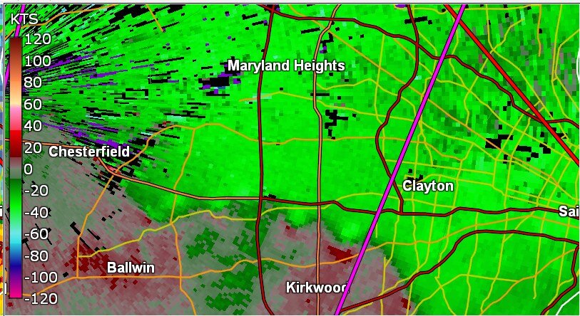
Radar confirmed in Ladue. A lot, and I mean A LOT, of very large, expensive homes there and so many trees.
-
Cycling back to its southwest and looks like a new circulation developing that is going to be a major issue for Vernon if it ramps up quickly.
. -
3 minutes ago, vman722 said:
The radar presentation on that cell has been just jaw dropping.
Almost looks like an eye-like feature in the middle of that debris ball. Gotta be a very, very large tornado. Thankfully where it's at is 100% rural and almost exclusively ranch land and some farm fields with very widely spaced farmsteads.
-
Seminole got nailed with likely multiple incipient circulations revolving around the parent, I mean it was quite a large mass as it went into town. Also, a lot of damage has probably been produced by the ridiculous RFD surging around it based on the coverage from local stations.
-
Confirmed tornado from KWTV's helicopter and KFOR spotter just west of Maud, OK.
-
1 hour ago, Chinook said:
another unbelievable tweet- this sped-up video shows the American flag nearly getting ripped off the flagpole and small trees bending as the tornado moves perhaps less than 1/2 mile away. It kind of looks like it's across the street, but I'm not sure.

The core of the vortex is directly across the street, but it was within the damage envelope, so it counts as a strike.
-
6 minutes ago, Amped said:
Watch just issued for most of OK east of the panhandle.
2 parts:
1) Kind of surprised it wasn't PDS tagged given probabilities
2) Apple size? Was hoping for something more outlandish, like DVDs
-
2
-
-
Nice supercell just SE of Farmington, MO. SVR warned currently
. -
I’m in Springfield and debating my next move. Stuff to the north is unattainable and group near Effingham is questionable.
May just sit & wait in Decatur. -
12 minutes ago, nwohweather said:
I could see things absolutely going off about 5 hours from now. That's a very primed environment with an eroding CAP. Also if I'm not mistaken that low is deeper than modeled, already down to 994 MB in WC Kansas
Pretty decent CU field down there and convective temp is almost achieved on the moist side of the dry line, roughly 91F. The subtle topographic enhancement from the Wichitas should be just enough.
-

Pretty fantastic structure on this non-severe supercell near La Place, IL.
.-
5
-
11/29/22 MDT Outlook Issued -- Regional outbreak possible.
in Central/Western States
Posted
LZK radar outage pushed to the right 2 days.
.