

Calderon
-
Posts
1,133 -
Joined
-
Last visited
Content Type
Profiles
Blogs
Forums
American Weather
Media Demo
Store
Gallery
Posts posted by Calderon
-
-
71mph (62kts) max gust at Love Field (KDAL) which also suffered a total power failure because of the storms.
1 confirmed fatality so far from the tower crane that snapped and collapsed in Old East Dallas, just NE of downtown.
KPMG Plaza suffered numerous broken windows from falling/flying debris from the adjacent Hall Arts Residences that's under construction in the Arts District.
Countless large trees, some over 100 years old, toppled in the Prestwood/Preston Hollow area of northern Dallas.
-
Dozens of damage reports in the DFW Metroplex, notably in Collin, Dallas, & Denton Counties with many large trees snapped and uprooted.
-
Levee has been overtopped on the Illinois at Nutwood. Also, the River des Peres in south St. Louis is about to go over Broadway and many, many businesses in Southtown and vicinity are pumping their basements.
-
A very intense cluster of storms is headed for the STL area, and this could be a very nasty situation given the hail history combined with both the Blues at home and Cardinals at home this evening. There's at least 70,000+ people downtown for the events, so this is a potentially critical situation evolving.
-
45.2 now
1) 49.58 ft on 08/01/1993
(2) 43.23 ft on 04/28/1973
(3) 42.52 ft on 01/01/2016
Now upped to 46ft.
. -
MS River at St. Louis is now forecasted to crest at 44ft on the 3rd but then hold at that level for 3-5 days. This would be the #2 crest and potential is there for the crest to be higher by up to 2ft depending on rainfall.
-
19 minutes ago, DanLarsen34 said:
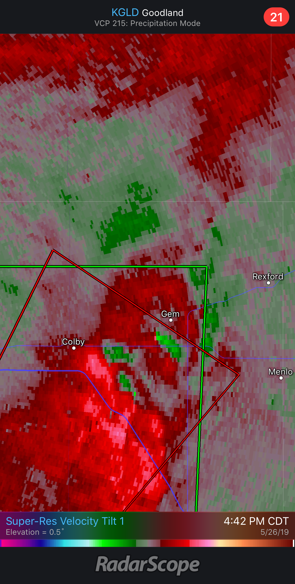
This is one of the oddest strong tornado signatures I’ve seen. Meso is completely wrapped in rain. No discernable CC drop, but we could be looking at a significant tornado.
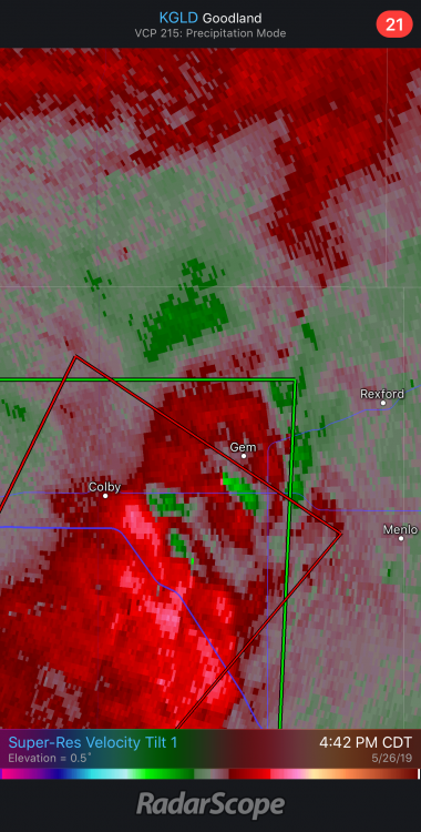
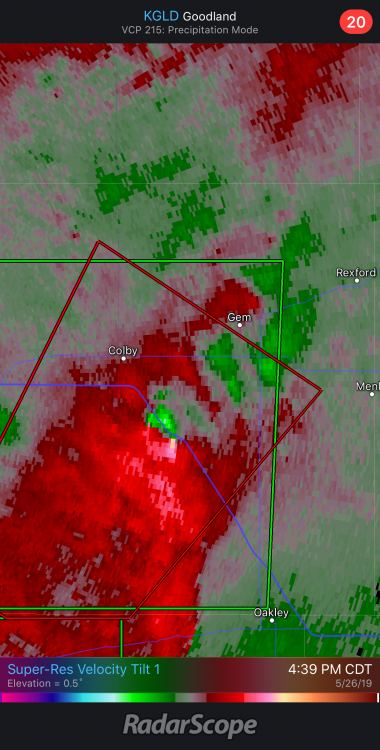
There's only widely scattered farms in that region outside of the towns, like Colby and Hays. It'd be extremely easy for a tornado to hit nothing but maybe some center-pivot irrigation equipment out there and nothing else.
-
Confirmed tornado in El Reno, moving east.
-
The Jefferson City tornado took probably the 2nd worst track into the city. Mind you, it’s one of the smallest state capitals in the nation, so the track last night was about as bad as it could get. The only track that would’ve been worse was an ESE trajectory right down US 50, crossing the entire breadth of the city from west to east.
. -
Does anyone have the text for the Jefferson City Tornado Emergency? I believe it was a first for the LSX office
I think you’re right. That is a bit surprising given the two significant tornadoes that’ve gone right through densely populated areas of St. Charles & St. Louis Counties and St. Louis City in 2011 and 2013.
.
-
Just now, Witness Protection Program said:
I saw the posted video and you can see debris in the roadway. This is after it had moved through the city and was dissipating.
-
 1
1
-
-
Funnel cloud near St. Paul in St. Charles County. Rotation is practically riding parallel to I-70 by about 3 miles north.
-
One thing that is concerning for metro St. Louis is the storms to the north, now in Illinois, have laid down a southward-moving outflow that the Jeff. City supercell is currently riding, and further warned on now in western St. Charles County. Another storm farther southwest, near Washington, is aimed right at STL and may intercept the outflow along the way and ride it in.
I guess I'll find out in a little while.
-
2 minutes ago, Wmsptwx said:
ef 2 likely?
At minimum.
-
At least one state office building has significant damage to it just east of downtown.
The worst damage pictures I've seen so far are at least solid EF2 in damage.
-
Supercell that produced the Jefferson City tornado is approaching Warrenton now and while broad, the rotation is starting to tighten as the RFD is surging forward along with ingesting an approaching thunderstorm from the southwest.
-
18 minutes ago, USCAPEWEATHERAF said:
It is possible vehicles were seen in the CC drop with debris likely thrown 25,000 feet high, cars could be lofted that high with that violent tornado. I saw an image on twitter and it was a monster. Joplin is in the crosshairs.
Eh, it would take unbelievable upward vertical motion and bending of physics to loft a 2-4k lb vehicle that high into the atmosphere.
And no, Joplin is not. They're just fine with just some thunderstorms.
-
7 minutes ago, sigerson said:
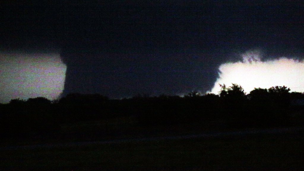
I humbly present a video frame as a tornado neared Golden City (I am competent with stills, but not at pulling them from video). This was from about six miles away. Anyone care to guess the size based on that?
The cats have gone to hide under the bed as another storm moves into Joplin. I think I'll join them. Wish us luck.
--
Steve Holmes
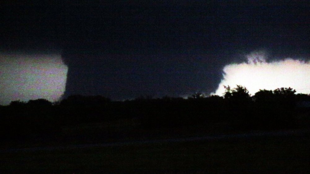
Hard to tell, but that is at least a massive wall cloud.
-
Jefferson City tornado also destroyed the Riley dealerships, a Toyota and GMC/Chevy/Buick are adjacent to each other. Numerous vehicles thrown considerable distances from the lots.
. -
Very likely that JC High School and Lincoln University were hit as well.
. -
YMCA completely destroyed and multiple apartment complexes have some building totally destroyed. Mayor is asking for heavy equipment from MO Nat’l Guard immediately.
. -
JC is asking for help from surrounding agencies to help with search and rescue ops.
. -
yikes if true
Thankfully looks like damage to the materials being used during the dome’s renovation.
. -
Missouri State Highway Patrol confirming extensive damage in Jefferson City with near total power failure.
This tornado, if still down, is headed towards Callaway Plant, a nuclear facility.
.

Tn Valley Severe Weather
in Tennessee Valley
Posted
Once the hail threat diminished some, that momentum really brought the wind to Smyrna, Walter Hill, and northern Murfreesboro. My folks took some tree damage and there were numerous snapped and uprooted trees near the Siegel schools and the VA Medical Center.