

Calderon
-
Posts
1,133 -
Joined
-
Last visited
Content Type
Profiles
Blogs
Forums
American Weather
Media Demo
Store
Gallery
Posts posted by Calderon
-
-
1 minute ago, Normandy said:
I don't mean tri state intensity. Just crossing three states. Relax yall
But it's only crossed 2...
-
I'm growing more concerned for the main part of Fort Polk with the potential of a northward turn in the track. It's a huge base but the main complex of buildings and all is very dense.
-
1 minute ago, Normandy said:
New tri state tornado?
No
-
It may miss all of that and hit the timber facility between Rosepine & Fort Polk, as well as a tech college.
-
3 minutes ago, Wmsptwx said:
I’d much there?
There are a couple subdivisions and at least 1 trailer/rv park. It's going to be a very close call for Rosepine proper.
The debris ball has taken a sharp north turn, so we're likely going to get a new cycle.
-
LCH seems to be waiting a little too long for my comfort to issue the downrange warning. It's less than 5 miles from the polygon edge and still no warning for Vernon Parish yet.
-
 1
1
-
-
I have an aunt that lives in Rosepine itself and it's making a beeline right at the town.
-
Just now, cheese007 said:
People on Mikey's stream just driving about as if nothing is happening
I mean, it is Oklahoma after all.
-
If storms do move into the Metroplex, I'd be willing to place a nice wager on a big hailer moving through Collin County.
-
Live Storms Media put out an on-site interview and good damage inspection of the site in question for the Bassfield EF4, for now, and really shows the foundation and anchoring extremely well.
-
1
-
 1
1
-
-
3 minutes ago, janetjanet998 said:
two mini hooking cells over SE GA both T-storm warned tagged tornado possible
but they are just north of an outflow boundary
the 2nd one may be trying to suck the boundary back in
Good thing the second cell didn't latch onto the OFB and produce because it went through a highly commercialized and residential section of Valdosta.
-
Meanwhile off the LA/MS coast, an interesting SMW.
QuoteSpecial Marine Warning
National Weather Service New Orleans LA
210 PM CDT Sun Apr 19 2020The National Weather Service in New Orleans has issued a
* Special Marine Warning for...
Coastal Waters from Boothville LA to Southwest Pass of the
Mississippi River out 20 nm...
Coastal Waters from Stake Island LA to Southwest Pass of the
Mississippi River from 20 to 60 nm...
Coastal waters from Pascagoula Mississippi to Stake Island
Louisiana out 20 to 60 NM...* Until 345 PM CDT.
* At 209 PM CDT, a wind bore front was located 50 nm east of
Pilottown, moving northeast at 50 knots.HAZARD...Wind gusts to nearly 50 knots.
SOURCE...Buoy.
-
1
-
-
Funnel cloud reported west of West Columbia, TX.
-
Just now, jojo762 said:
Cell north of Bay City, TX (west of HGX) starting to acquire rotation and a ZDR-arc. Hmm...
Rotation aloft continues to gradually build but still needs to tighten up more, and with more heavy showers developing in the inflow catchment area, not sure if it'll go all the way before moving offshore and becoming a shipping and rig hazard,
-
Also watching a pair of cells northeast of Victoria, TX. The northern one does have some mid-level rotation evident and moving into an undisturbed environment as it moves towards the southern half of metro Houston.
-
3
-
-
New TOR watch for MS has some intense probs. 90/70 for a non-PDS watch is rather interesting.
-
36 minutes ago, SmokeEater said:
Wouldn't they actually be considered the next day? If that's the case they were in a 10% hatched.
Sent from my SM-G973U using Tapatalk
No, at least per SPC guidance of 12Z to 12Z next day for reports.
-
8 minutes ago, BornAgain13 said:
How big was the Tornado that hit Moncks Corner, SC?
CHS is doing there surveys currently and have not released any preliminary ratings, other than the potential EF2 at Edisto Beach.
-
Nope, I believe it is from the first tornado, which dissipated before hitting Bassfield.
Ah, gotcha, there was a little confusion. I can respect that rating because clearly there was a flaw in construction.
. -
LIX keeping it at EF3 as of now.
I thought that pic was from the 2nd tornado in the Bassfield supercell?
. -
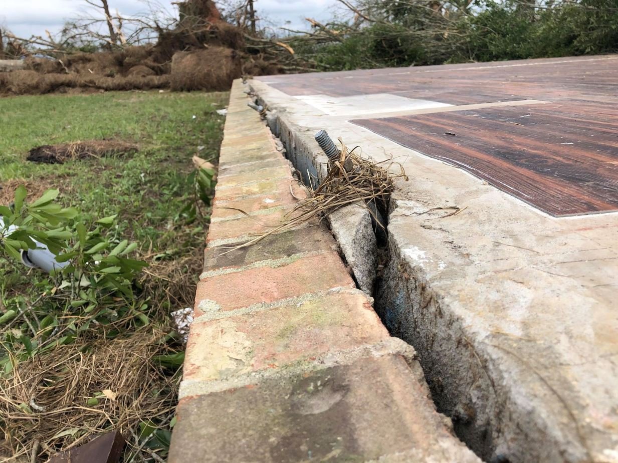
This area has not been surveyed yet. Some close up shots reveal that the anchors were partially ripped from the foundation as well...
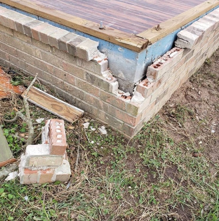

My problem is the vegetation and grass immediately adjacent to the foundation. One would expect an EF5 to not only have the force to do that to a house, but also chew up the grass and trees around it.
The tree partially laying on the slab is appears to be either a Laurel Oak or Water Oak, but very easy tree to knock over and/or split. It happens frequently in summertime storms in the southeast. A majority in the background were pine, which are softwood and pliable, but there’s a substantial amount of surface bark left.
Unless there is more drastic damage out there we haven’t seen pics of yet, I see it staying at EF4.
. -
So how many TOR Emergencies did we wind up with from this outbreak, nearly 2 dozen?
-
1
-
-

Upson County (not sure which state)
Georgia
. -
Just now, Quincy said:
Scooba got hit by a long track sig tor on 2/2/16...
And 4/15/11


Severe Weather for 4/19-4/23
in Central/Western States
Posted
Mississippi