.jpg.2573028626d558966424be2bdf9b8490.jpg)

Buckethead
-
Posts
2,433 -
Joined
-
Last visited
Content Type
Profiles
Blogs
Forums
American Weather
Media Demo
Store
Gallery
Everything posted by Buckethead
-
Just got home, there's about 2 inches and the snow has stopped. Good start to the week. Sent from my SM-G970U using Tapatalk
-
Just had a heavy sleet shower pass through. Its been wave after wave of mixed bags all morning at the office (3100'). I don't know how much is at the house(4360), but it's definitely over an inch. Sent from my SM-G970U using Tapatalk
-
30° with moderate snow and a nice coat on the pavement already down to 4000' in Wolf. 33° and rain down at 3100'. Sent from my SM-G970U using Tapatalk
-
Light snow and 33° up here in Wolf. Sent from my SM-G970U using Tapatalk
-
KMRX issued a statement for the North side of my mountain (¼ mile from me) calling from 2-4" above 4kft and up to 6" closer to 5kft through tomorrow night. Sounds good to me. Sent from my SM-G970U using Tapatalk
-
I'm pretty optimistic about this nwf tomorrow too. It looks to be good for an inch or two for the high border areas. Sent from my SM-G970U using Tapatalk
-
22° with a little powder on everything this morning. It's really nice that the mud froze, makes driving a little better! Sent from my SM-G970U using Tapatalk
-
I have a nice coating of powdered sugar up here. It makes the mud pretty. Sent from my SM-G970U using Tapatalk
-
28° and light snow at 4360 in Wolf. Sent from my SM-G970U using Tapatalk
-
I have a 1300' drop in elevation in 3 miles from my home to work and every bit of it was covered in solid ice. I did a 360° 3 times coming down but I made it in one piece. Y'all be careful this morning. Sent from my SM-G970U using Tapatalk
-
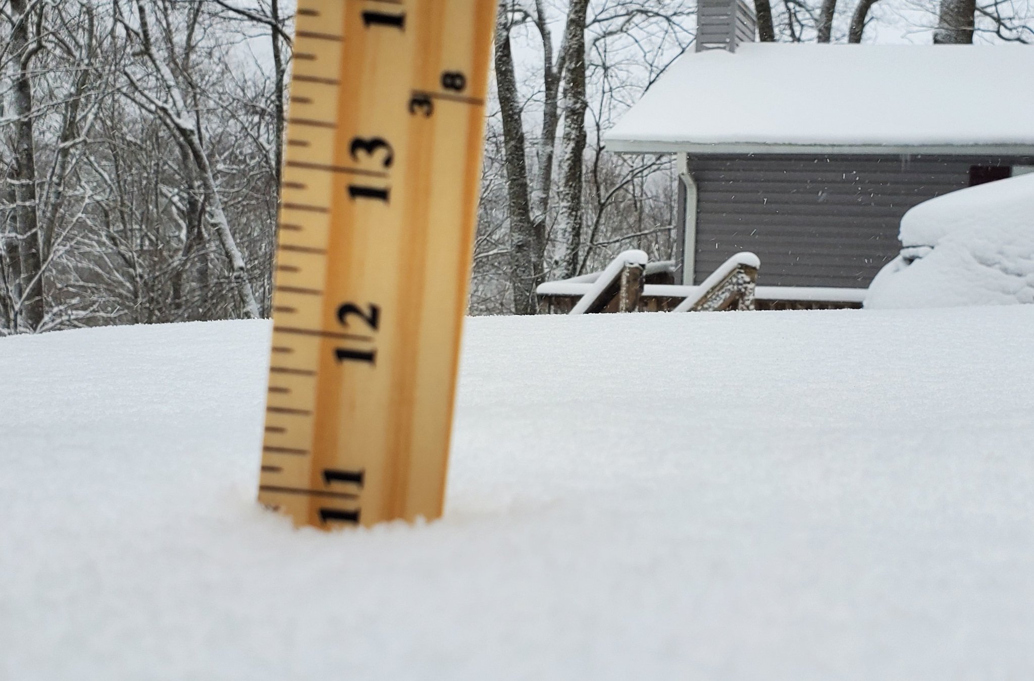
Diamond dust and the moonlit snow covered mountains...just all kinds of awesome outside right now. But man is it cold! I think 11" is where I'm stopping for this event which puts me at 28.5" since 12/1. Sent from my SM-G970U using Tapatalk
-
Getting close to a foot now. Had a high of 6.7°.

-
It makes me happy to see so many getting to see flakes on Christmas! I'm over 9" and still going. That 5° air temp is noticable! Took a couple of pics in my yard just now for yall. Sent from my SM-G970U using Tapatalk
-
Merry Christmas yall! Haven't measured the snow just yet but I know it's currently 5.7° here and still snowing good. Getting the truck door open for my wife was a feat of strength. She's on her way to plow the roads in Asheville today. Sent from my SM-G970U using Tapatalk
-
I'm down to 15.6° and past 6" in the shallowest spots and over 7" on average. And it's still coming down at a good rate! Sent from my SM-G970U using Tapatalk
-
It's getting nuts here. Down to 22° with sustained winds in the 25-35mph range and gusts into the 40's. Visibilty is almost down to zero. Here's a video I just took. I was 5' from that tree. https://www.instagram.com/p/CJMybpUHTuT/?igshid=zll9ymt8uxme Sent from my SM-G970U using Tapatalk
-
Almost 2" already in about 45 minutes. Down to 26°. Sent from my SM-G970U using Tapatalk
-
And just that fast I'm down to 34° with heavy snow and everything is white. Awesome. Sent from my SM-G970U using Tapatalk
-
I dropped 4 degrees to 35° in the last 10 minutes and have a rn/ip/sn mix. It's coming. Edit: changed over to all frozen, mostly snow about 3 minutes later. Sent from my SM-G970U using Tapatalk
-
Can confirm. Sent from my SM-G970U using Tapatalk
-
Gotta love seeing this! Mesoscale Discussion 1875 NWS Storm Prediction Center Norman OK 0128 PM CST Thu Dec 24 2020 Areas affected...southern and central Appalachians Concerning...Heavy snow Valid 241928Z - 250000Z SUMMARY...Heavy snow is forecast to develop behind a cold front this evening. Low visibility and rapid accumulation from snow rates of 1 to 2 inches per hour will be likely. DISCUSSION...Afternoon water vapor imagery showed a deep upper low and expansive area of cyclonic flow across much of the eastern US. At the surface, 19z analysis showed a cold front progressing eastward across the southern Appalachian highlands. Along the front a developing wave cyclone was observed across northeastern Georgia and southeastern Tennessee. Increasing lift from an embedded shortwave trough within the larger upper low should help intensify the developing surface cyclone as it rapidly moves north along the front into the central Appalachians this afternoon. With increasing pressure falls expected to develop along the frontal zone, enhanced cold advection in the low levels should rapidly cool the atmospheric column to support snow development by late this afternoon. Lingering instability from steep mid-level lapse rates, strong lift along the front, and enhanced convergence from windward side upslope flow should support moderate to heavy banded precipitation to the immediate west of the cold front. Snow rates of one to two inches per hour will be possible (especially along the crest of the Appalachians) through this evening. https://www.spc.noaa.gov/products/md/md1875.html Sent from my SM-G970U using Tapatalk
-
Snow showing up NW of MRX and in NW GA now via mping. Just ticked down to 39° here in wolf at 4360. Sent from my SM-G970U using Tapatalk
-
The wind is already roaring on the ridgetops tonight. Sounds like a jet engine. Sent from my SM-G970U using Tapatalk
-
Upgraded to WSW's in Madison, Yancey, Mitchell, Avery, Watauga and Ashe now with WWA's elsewhere. Sent from my SM-G970U using Tapatalk
-
I see Morristown NWS has already hoisted a Winter Storm Watch on their side of the border. Things are looking up! Sent from my SM-G970U using Tapatalk