tavwtby
-
Posts
2,440 -
Joined
-
Last visited
Content Type
Profiles
Blogs
Forums
American Weather
Media Demo
Store
Gallery
Everything posted by tavwtby
-
 yeah understandable, still funny though
 -
still laughing at the range here, soon to change I'm sure with current runs, but HA!

-
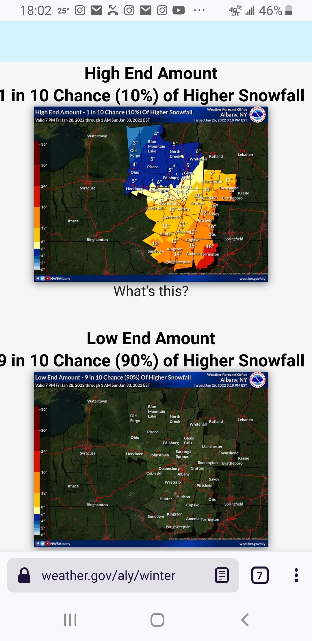
ALY has high end 18" and low end of like 0", with likely 8, quite the range there...
-
I meant the winter as a whole, but that storm was good not great, think I ended up with close to 2', but I was out driving around in it in my first truck, and at one point snowing so hard I could only see by the faint glow of street lights, my opinion was better than 93, imby at least, as a whole, I'd rank 78, 13, 96, and there's a bunch more like 82 in there... this one has that feeling to it, I know now it's way more to it than muh feels, but...muh feels say we snow big
-
that was another great closed off storm, and as I said before the start of probably the most epic run of snow for a month that I remember, 40" on my roof, but 96 was great too, it just found was to snow, like every other day that winter...77-78 was another one
-
yeah you're right, that was my last winter in wtby, since moving to Winsted my last 12+ was 1/4/18 if I got the date right, came close in the March storm same year, but 13 was epic in southeast wtby, 32"official, that was more than 78, but nothing will beat that storm in my opinion, just incredible edit:12/17/20 I got 16.5"
-
it's been quite a while since I've seen more than 16" imby, would be great to see a complete region wide 12-24+ storm, those that are also talked about, like 78, 93,96, PD1&2, etc. I think the last big one for the whole forum might have been 15? correct me if I'm wrong, and wor folks only got like 12-18 while east was tickling 3' iirc
-
usually storms this potent tend to have two deform bands one less than the other but it happened I believe in 2011, and 15, always a secondary max, with better ratios less qpf though
-
Moderate sn now was borderline heavy for a grip, eyeballing about 1.5 out there, and I thought this was going to fizzle out
-
Lord!! fun tracking this one!
-
nice little .25" to refresh things upon my return from GA, is next weekend still a thing, I haven't looked back through the thread, last I saw GFS had a monster but it was by itself there...
-
wife just said 4.6", and now it's raining, so not sure how much before change over, but 4.6 it is, ironically the biggest of the season..
-
haven't heard from home yet but based on surrounding reports I'm guessing 3-3.5" there in Winsted, of course that microclimate can have 3 in one area and 6 in another up the hill
-
I'm in litchfield county, 5 miles from the MA border, and alb just upped the hogh end to 14", so 8-14 now
-
I think from just north of me up to SVT are going to get slammed with that east flow and cold damming
-
wife tells me it has begun in Winsted...son on snow table duty while I'm down here.
-
Monitoring a potential important TV to East Coastal storm: Jan 17
tavwtby replied to Typhoon Tip's topic in New England
yeah it's actually coming down good here in cartersville, not sticking to surface yet but boy am I glad I toughed it out and finished driving yesterday cause it looks like a dumpster fire on 81 now..WSW for Northern litchfield county, NWS alb says 5-12 before change, quite the range, I'd expect 6 imby maybe and a foot 5 miles away in Norfolk, they always get that microclimate snow with the extra elevation -
Monitoring a potential important TV to East Coastal storm: Jan 17
tavwtby replied to Typhoon Tip's topic in New England
just got to north georgia and on top of 20-30 mph gusts at 35*, wet snow is beginning to mix in, looks like a rough go for the upland SC area and north of Charlotte with ice, they are freaking out here because 2" expected, more NE towards the NC border it's funny how much different the approach is... I remember many moons ago while working in Houston, it snowed, was like a once in 20 year thing, city basically shut down for an inch -
Monitoring a potential important TV to East Coastal storm: Jan 17
tavwtby replied to Typhoon Tip's topic in New England
is that the one that laid like 3" of IP across at least western CT? I seem to remember an early 90's storm that was similar to this setup where we got hammered with IP, after an initial quick thump and back to snow to top off, was a mess -
Monitoring a potential important TV to East Coastal storm: Jan 17
tavwtby replied to Typhoon Tip's topic in New England
what's preventing this from redevelopment off the coast? trying to understand why normally these would transfer, is it SST, baroclinic zone? why exactly would this not transfer with the amount of energy out ahead of it, or is that the reason why? -
Monitoring a potential important TV to East Coastal storm: Jan 17
tavwtby replied to Typhoon Tip's topic in New England
deform band from poconos up to Concord? -
Monitoring a potential important TV to East Coastal storm: Jan 17
tavwtby replied to Typhoon Tip's topic in New England
looks like I'll be having a fun trip from WV to GA on Sunday morning, local calling for a foot where I'm staying, and about 4" where I'm going...3 days to continue SE trend and at least hug instead of cut and change over, is today's system stopping to eastward progression of sundays system, which is why it's been showing so far west? -
Monitoring a potential important TV to East Coastal storm: Jan 17
tavwtby replied to Typhoon Tip's topic in New England
I would not mind a hug track for my neck, a BM storm doesn't really hit me as good as SEMA and just NW, a 495 special, but a canal track I like for mby anyway, don't mind a bit of taint, I think it's going to be something similar though, at this range, has the s/w even come ashore yet? -
Monitoring a potential important TV to East Coastal storm: Jan 17
tavwtby replied to Typhoon Tip's topic in New England
HA!!assuming it's Ryan, as that's what was forecast this far out and discussed three pages back, no?