tavwtby
-
Posts
2,814 -
Joined
-
Last visited
Content Type
Profiles
Blogs
Forums
American Weather
Media Demo
Store
Gallery
Everything posted by tavwtby
-
1.25 on the day, like Will said, very sparkly in the light at night, nice little perfect dendrites too, i keep trying to get a pic of one but they're so dry they vaporize on contact with anything not very cold
-
cracked an inch here on the day and still lightly snowing, awesome feel out there...
-

Feb 28th-March 1st long duration Miller B threat
tavwtby replied to George001's topic in New England
someone mentioned how the NAM nailed the small event we're seeing today, I don't recall seeing it on other models, perhaps it's onto something, I mean we're closing in on 48hrs or so from go time, so within range -
Feb 28th-March 1st long duration Miller B threat
tavwtby replied to George001's topic in New England
fwiw, there's some pretty good growth this go around with the pixie dust... very nice wintry feel outside -
Feb 28th-March 1st long duration Miller B threat
tavwtby replied to George001's topic in New England
looks to me like the primary digs a bit more this run, still don't like the SE ridge though, think it's the doom of this, it has nowhere to go but shredded east, maybe I'm wrong, still not awful for south areas -
Feb 28th-March 1st long duration Miller B threat
tavwtby replied to George001's topic in New England
second round of pixie dust has begun, had .8" from this morning, amazing that I'm excited about measuring snow in tenths...if I get another .4" I'll break 16 on the year! -
Feb 28th-March 1st long duration Miller B threat
tavwtby replied to George001's topic in New England
I'll take it..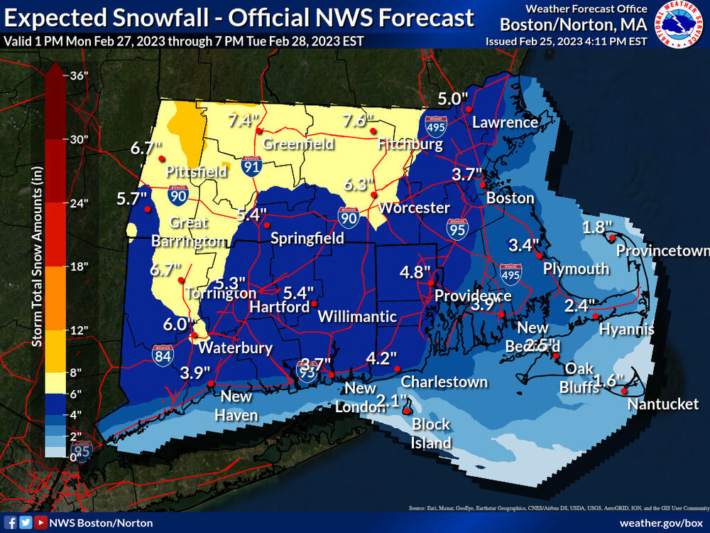
-
Feb 28th-March 1st long duration Miller B threat
tavwtby replied to George001's topic in New England
at this rate, I'd not be surprised if we get as much Monday night as we do today, shredded mess churning between -
Feb 28th-March 1st long duration Miller B threat
tavwtby replied to George001's topic in New England
unreal... excuse is we have to spend the money, so we get at least that allocated for next year, no thought into actually saving money... but making more potholes for job security come spring and summer, all at prevailing wage too...btw, official .8" today so far, nice little walk around in the snow was pleasant -
Feb 28th-March 1st long duration Miller B threat
tavwtby replied to George001's topic in New England
I have almost an inch from the pixie dust today, plows actually out -
Feb 28th-March 1st long duration Miller B threat
tavwtby replied to George001's topic in New England
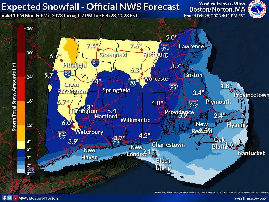
sticking with 6-10" for NWCT up to SVT, that hasn't seemed to waver, that SE ridge is what's concerning as far as shredding this out and shooting it SE with that block -
Feb 28th-March 1st long duration Miller B threat
tavwtby replied to George001's topic in New England
sure we'll see a NAM run within the next couple days of ridiculous amounts, seems to always happen -
Feb 28th-March 1st long duration Miller B threat
tavwtby replied to George001's topic in New England
one thing that still concerns me is the antecedent airmass, we have yet to have a good one leading up to an event, marginal sfc temps, but colder aloft so it's promising -
Feb 28th-March 1st long duration Miller B threat
tavwtby replied to George001's topic in New England
that's what I was thinking, was even a little more conservative with 6-10" imby, more east... -
got about half inch then dried out now drizzle at 33...meh... looking forward, congrats north folk
-
lock it in! I'm just over a foot from my lowest ever recorded 2015-16, and over 60" departure from seasonal snowfall avg... need to make up ground here and nickel and dime time is not gonna do it
-
yeah I've yet to fill in, I'm at 14.2" to date.
-
just under 2.5" on the board here, driveway and roads maybe an inch plowable anyway they were waking people up this morning
-
strange meso low formed on the front and it's been nearly two days of sustained 20-30 winds, and absolutely pouring... I see winter is over back home where it's now near 40, from a low in the teens
-
bottomed out at -15 both at my station and Winchester center vol. fire, definitely some issues back home with cars starting, chicken waterer froze etc. it actually dropped down here as well it's 70, was near 90 if not 90 yesterday
-
-9/-20....damn with a stiff 10-15 breeze, imagine if there was no wind??
-
doing construction a very good portion of my life, I've worked in 105F and 5F, and I'll take the 5F any day, it sucked for sure, but better than dehydration and as you said you can always layer up, fingertips be damned!
-
first time this season we've closed the coop door
-
correction it's -1/-8 at home now
-
down to 3/-8 at home and I know it's a hard comparison to square, but in WPB it was near 90 at 1600hrs today and by 1800 it was close to 70, still plenty balmy compared to home but impressive fropa nonetheless