tavwtby
-
Posts
2,440 -
Joined
-
Last visited
Content Type
Profiles
Blogs
Forums
American Weather
Media Demo
Store
Gallery
Everything posted by tavwtby
-
what about April 97, although short lived and before 2000
-

1/9-1/10 Now Morphing to Less-Than-Exciting Power Cutter
tavwtby replied to Torch Tiger's topic in New England
snowing to beat the band here in Winsted to start sitting right around 30 -
1/9-1/10 Now Morphing to Less-Than-Exciting Power Cutter
tavwtby replied to Torch Tiger's topic in New England
just watched a documentary about the chestnut blight, incredible how many that wiped out and how much of a staple they were to Appalachia before it happened, and those are huge trees that you could cut a certain way, so they would grow back and not have to kill the tree, pretty fascinating stuff, can imagine getting clocked by them in a wind storm tho would do damage -
planning on driving to Florida for work on the 19-21, I usually break it up in 3 segments, looks like it may be an interesting drive this go around
-
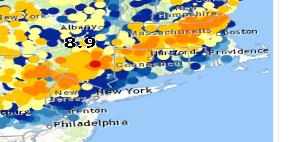
I'm still skeptical about that 17 in Granby, I was up there this morning and looked about the same as my place and through barkhamsted, but could have been a little micro climate situation, idk, but it sticks out with most around here between 10-14", good job with this btw, it's nice to see a summary after to see the pattern of snowfall
-
other than the 15th, I don't see any measurable on guidance by the time I leave for soflo for a month... won't be back until mid Feb, hopefully back ender this year, sitting at 14 on the season, just broke 41 last year, and barely got 30 year before, avg here is like 78, first couple winters here were great, both 90+, then a couple decent mixed in with the rats.
-
17 in Granby?? that's a crazy outlier, maybe caught more from rd 2, but overall a fairly consistent distribution in NWCT, over to ENY and up to SNH... actually that stripe went down to PA, was pretty well modeled I think.
-
little pixelated but you can see the stripe of 10-18" right down to PA up to NH ..
-
it appears we have a zone from Ulster/Duchess cty area up to the Lowell area plus and minus about 30 miles that got 10+, that sound about right?
-
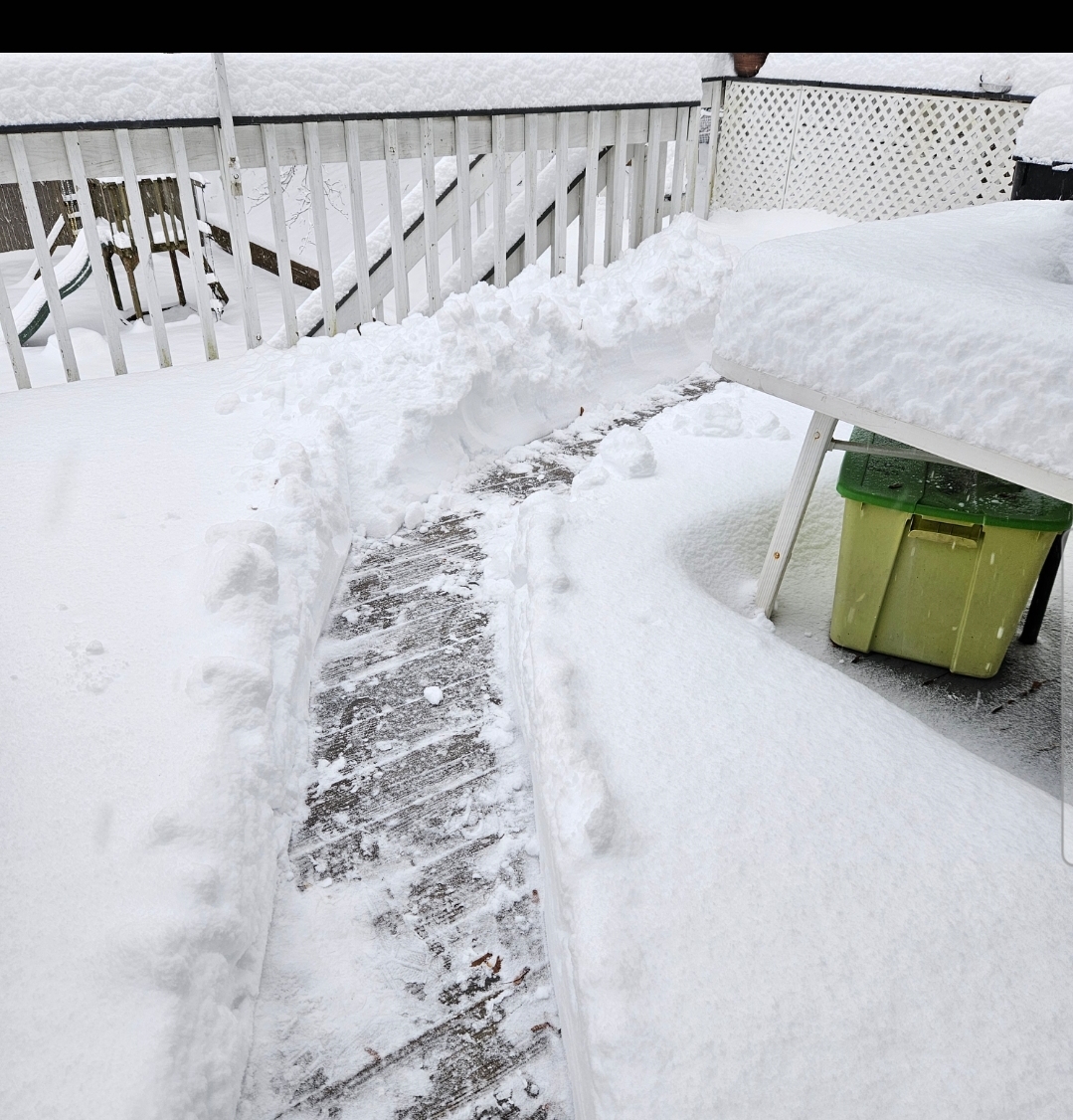
limped our way to 12.5" here with this last burst coming right as we finished doing the snow, which was as hard as it was last night surprisingly because radar doesn't look good, but under 1/2mi vis for almost an hour put down the final half inch... nice storm here for us, feel for the south peeps, looks like it's rockin up in orh cty up into SNH
-
looks like it's rockin from about wilbraham up to Lowell, nice band consolidating there
-
looks like the last gasp incoming, if it sticks together, otherwise I'm going out to clean up, we have a newly paved driveway, so it's going to be a pleasure with the new blower as well... nothing worse than a bumpy driveway trying to snowblow or shoveling...total as of now 11.5, need a good push to top a foot
-
from what I just read in the AFD, it seems like a struggle between the SLPs as soon as promise shows, it dissipates fairly quickly
-
so two distinct SLP, an inverted trough, and the ULL coming in the stall and strengthen the more tucked SLP, am I reading that correctly???
-
.Update...As of 9:30 AM EST...MSLP analysis now shows two distinct areas of low pressure off the coast, one located east of the 40/70 benchmark and another just south of Long Island with an inverted trough extending back across the eastern Catskills from this second surface low. At the same time, GOES 16 water vapor imagery shows the approaching upper shortwave embedded in a longwave trough currently located over eastern PA. As this upper shortwave tracks northeastwards through the next couple hours, it will help to keep that second SLP minimum tucked into the coast, and will allow the surface low to strengthen with the arrival of better upper divergence.
-
radar seems to be consolidating now, hopefully everyone can cash in on round 2 today
-
Joe the toe wound be buried under my snow he's so short
-
if we can get one of these heavy bursts to sustain for a couple hours it'll be another few inches, they seem to last a half hour then peeter out and start back up, wind is picking up too now... don't think I got above 25 the entire time, it was 25 when it started and is now.
-
it's ripping SN right now, on and off bursts of SN+
-
also, Norfolk had 12 as of 6am, so I'm sure that's gone up since just for reference
-
i measured 10 maybe an hour ago, but looks like another .5 has fallen since...radar filling nicely out west of us, so maybe we can get some goods until afternoon
-
this thing is really cranking up, winds are swaying trees, knocking whatever stuck on them last night off, had a brief period of SN++, but it was short lived, back to just SN
-
shoveled a path to the stairs, not exactly man snow, but not exactly powder either, should clean well, wrap around is filling in nicely, Hrrr really seemed to nail this one from just before go time up to now
-
starting to pick back up to mod SN now, had a good lull from about 330-730, I've got 10 even, Norfolk reporting 12, a couple of reports in dutchess and Ulster cty NY coming in near 14, that band was legit last night... would be nice to pick up a few more and get over a foot
-
have exceeded my expectations already as we approach 10" here, and if guidance verifies, tomorrow late morning should ramp up some deform and pick up possibly a few more, right on!