

SnowlieSnowstormson
-
Posts
166 -
Joined
-
Last visited
About SnowlieSnowstormson

-
It looks looks like the Bz measure is trending unfavorably - Ryan probably knows a lot more about this than me lol
-
Everyone should be ready in the next 5-10 mins onward… looks like an encore of sorts on the way
-
It has been shifting greenish compared to earlier… it’s been trending a bit back up and in about 10 minutes there might be a decent burst of color based on the graphs- be ready, use your camera and set your exposure on it to capture some more color
-
Just want to give a huge shoutout to @CT Rain for using meteorological knowledge, pointing out upper level conditions as a plus factor last night vs hugging snow maps to at least not overly pare back totals in CT like some of the more amateur folks on Twitter and elsewhere who rolled out like 5 forecasts and overly bought into the modeling whipsaw.
-
KOKX - Super-Res Reflectivity 4 9:22 AM #ctwx #nywx Higher beam scan shows central CT about to explode on radar
-
Sunday, December 17 - Monday, December 18, 2023 Storm
SnowlieSnowstormson replied to weatherwiz's topic in New England
I just checked out the 20z HRRR and saw some eye popping shadings on there for CT… any Mets concerned or are these #s likely inflated?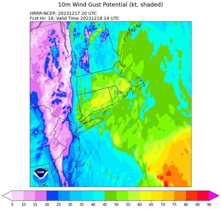
-
Can you post prior two frames plz
-
Where would the band set up in relation to the black/grey shading? On top of it or just the left?
-
Already looking better at hour 24… coming west
-
Triple buns is a good sign!!!
-
Potential Major Noreaster 10-26 through 10-27
SnowlieSnowstormson replied to ineedsnow's topic in New England
BOX did a great job with their wind advisories and high wind warnings -
Potential Major Noreaster 10-26 through 10-27
SnowlieSnowstormson replied to ineedsnow's topic in New England
9 out of 10 wind events don’t pan out. It’s simple and called the Squamus Effect. I can explain. -
Warm at third beach too
-
Looks like the LLC is starting to slowly merge with the MLC.

