

Eduardo
-
Posts
1,030 -
Joined
-
Last visited
Content Type
Profiles
Blogs
Forums
American Weather
Media Demo
Store
Gallery
Everything posted by Eduardo
-
Easily gusting over 50mph in Brooklyn Heights.
-
Gusty here in Brooklyn Heights too. Easily in the 45–50mph range!
-
October 2020 General Discussions & Observations Thread
Eduardo replied to uofmiami's topic in New York City Metro
That's nuts! You have to wonder what it looks like once it's rolled forward (with shortening wavelengths, etc.). Thanks for finding these! I hate tossing '95 out there because it stirs up weenieism. I didn't realize that '95 had such low heights in the GOA and up top. NE PAC warm blob was sorta there though. -
October 2020 General Discussions & Observations Thread
Eduardo replied to uofmiami's topic in New York City Metro
For comparison, does anybody have a 500mb composite for October 1995? And maybe a global SST map? Just curious since that also was an active hurricane season + Niña autumn following a Niño, correct? -
October 2020 General Discussions & Observations Thread
Eduardo replied to uofmiami's topic in New York City Metro
::Scratches head:: This year's Sept./Oct. composite actually seems directly opposite to how Niña's typically behave in Canada and the NATL too. Do we know why? And are we going to wait around all winter for a Niña atmospheric "coupling" (hope I'm using the term correctly) like we did last year with the Niño? -
Yeah that was my first thought when I looked today. Can anyone explain the conservative LF intensity forecasts? I can see the low OHC in the northern gulf inducing some weakening before landfall, but what's stopping ζ from just taking off in the meantime?
-
Yeah I fully withdraw this statement. She's definitely looking better now that she's exited the YP.
-
She's all hollowed out. Reminds me a bit of Isidore in 2002.
-
Well, save for the "time period" before radar was invented.
-
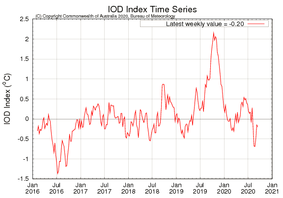
Quite a difference in the IOD from this time last year. Hopefully, that bodes well (or at least less bad) for our winter prospects this year.
-
Yes we learned this hard lesson last year. Is there any evidence that the converse produces a better result for us (i.e., a tendency for the MJO to hang around in the colder phases)?
-
Are either of you able or willing to speculate what significance (if any) an opposite IOD state at this time might hold for this coming fall and winter?
-
Where did it stand at this time last year? Trying to figure out if it’s going to toss a wrench into our upcoming winter’s pattern like it did last year.
-
SVR potential late Wed-Thu August 26-27 NYC metro
Eduardo replied to wdrag's topic in New York City Metro
Take it back. Just had the loudest clap of thunder this summer! -
SVR potential late Wed-Thu August 26-27 NYC metro
Eduardo replied to wdrag's topic in New York City Metro
Was going to say the same thing. I’m in Lindenhurst and it’s a very still storm. Tons of lightning but minimal thunder too. -
Bands of Heavy Rain along and se of I84 Sunday 4AM-11PM
Eduardo replied to wdrag's topic in New York City Metro
Given the trend the past few years, it’s tough to bet against sneaking in a few 90+ days in Sept/Oct. -
Or the Hazel-type scenario (assuming you’re not talking about a purely-tropical cyclone and you’re focusing strictly on winds). I know that the winds here were intense with that one, but did she have a dry eastern side as well?
-
Potential few SVR/FF events parts of NYC forum Wed-Thu 7/22-23/20
Eduardo replied to wdrag's topic in New York City Metro
Mehhh. 8-minute downpour. But some decent, ongoing CTG anvil lightning. Oddly, not much thunder though. -
July 2020 General Discussions & Observations Thread
Eduardo replied to Rtd208's topic in New York City Metro
Should that pattern remain stable during the heart of hurricane season..... -
Just had a pretty mean gust here. Easily TS force!
-
So far, I’d say “ample.”
-
This band rotating onto the south shore of LI now might bring down some decent winds.
-
I think the winds in firehouse *to the east of the center might pack somewhat of a punch....I'm expecting it to come in waves. As is usual with tropical systems up here though, the heaviest rains are on the western side.
-
July 2020 General Discussions & Observations Thread
Eduardo replied to Rtd208's topic in New York City Metro
Top-notch beach weekend. Water temps also quite warm for this time of year! -
Agree! Unlike the earlier storm, this one held together nicely as it came across the island. Vivid lightning and gusty downpour. Overall, a solid a respectable storm here!
