

Eduardo
-
Posts
984 -
Joined
-
Last visited
Content Type
Profiles
Blogs
Forums
American Weather
Media Demo
Store
Gallery
Posts posted by Eduardo
-
-
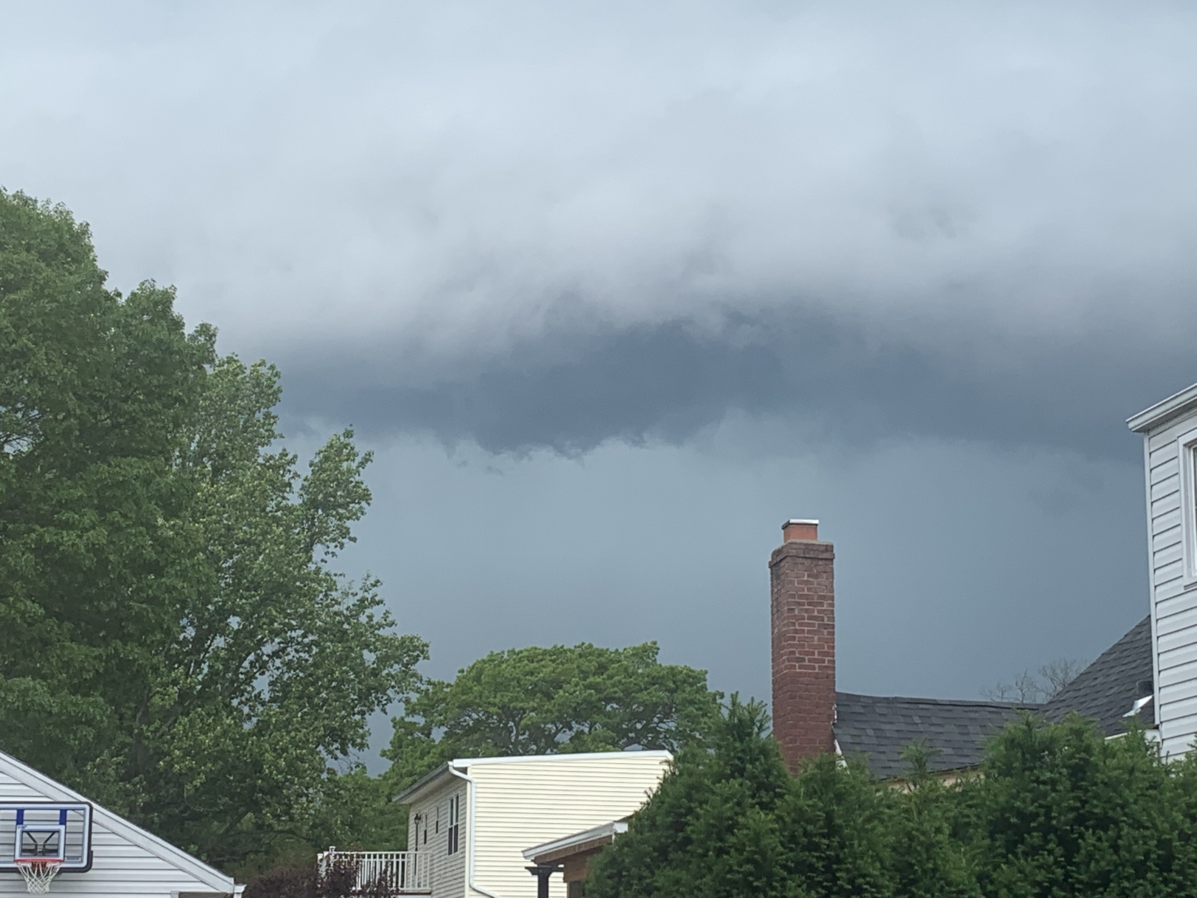
This band rotating onto the south shore of LI now might bring down some decent winds.
-
8 minutes ago, David-LI said:
Was expecting more here in Nassau County. This does not look like a TS at least where I live.
I think the winds in firehouse *to the east of the center might pack somewhat of a punch....I'm expecting it to come in waves. As is usual with tropical systems up here though, the heaviest rains are on the western side.
-
Top-notch beach weekend. Water temps also quite warm for this time of year!
-
33 minutes ago, psv88 said:
Crazy storm here
23 minutes ago, jm1220 said:I know-absolute torrent and brilliant lightning. LOUD thunder.
17 minutes ago, psv88 said:Yea lots of CTC, thunder is rolling.
Agree! Unlike the earlier storm, this one held together nicely as it came across the island. Vivid lightning and gusty downpour. Overall, a solid a respectable storm here!
-
55 minutes ago, jm1220 said:
No hail where I am in S Huntington but some loud thunder and heavy rain. Maybe 5 minutes south on Rt 110 looks worse.
Yeah they certainly petered out as they stumbled their way southward though. Here in Lindenhurst, the sky darkened, but we got nothing aside from a 2-min bout of drizzle. Sun's back out now.
-
Yeah wow. Sun came out for about half an hour here in Lindenhurst and now, out of nowhere, have heavier rain than before!
-
 1
1
-
-
Sky looked ominous, but just a breezy downpour here in Lindenhurst.

-
1
-
-
For the past few years, it seems like our preferred weather patterns are “fast-forwarded” by a few months, delaying springs and summers on the front end, but extending them on the back end. What explains it?
-
1
-
-
1 hour ago, bluewave said:
Snowing along the South Shore.

Failed here in Lindenhurst. Saw it breaking up overhead. Boooooo!
-
One thing I have learned over the past few years: Broadly speaking, Pacific patterns have staying power in this climate regime and LR models often break them down too quickly.
In 2013-14 and 2014-15, I distinctly recall models breaking down those glorious -EPO patterns only to see it pushed back over and over again--which of course redounded to our benefit.
2018-19 and 2019-20 was the flip side of the same phenomenon and we saw raging +EPO patterns remain robust in spite of LR models constantly forecasting their reversal.
In future winters, we should keep this in mind as we try to sift out the head fakes.
-
1
-
-
2 hours ago, WestBabylonWeather said:
Long Island can be tricky
last storm was snowing at my house in west Babylon while it was raining 2 miles south of me.
Yeah I am in Lindenhurst and this does happen from time to time.
6.4” on the year so far.
-
46 minutes ago, coastalplainsnowman said:
Starting to think that there really is something to the idea that people forget how to drive in wintry conditions when they don't happen for awhile. For a few hours today driving was a little rough, but nothing we haven't seen 50 times in the last 20 years. Still people were driving like idiots today. Spinouts up and down Wantagh Parkway. The last time we had anything rough on driving must have been in the 17/18 season.
I second this. Just drove home to LI from a ski trip up at Mountain Creek in Vernon, NJ where so many of the drivers seem to suffer from delusions of invincibility. Had a car pass me in excess of the speed limit on a snow-covered secondary road. About a mile ahead, we saw that he had gone off the road into a tree. Several spin outs on I-80 too.
Not the night to be in a rush folks. Not worth the risk!
-
Last year, I finished with a single-digit snow total. Today is the first time I fear that may repeat itself. Looking pretty ugly moving forward.
-
5 minutes ago, snowman19 said:
If it does get colder on 1/20, that doesn’t cancel out the previous 3 weeks of warmth for this month. The last week of January won’t salvage this month lol
Really a matter of perspective. Most of us don’t care about an almost-certain positive monthly departure so long as we are looking ahead to a pattern that can produce.
Looks like a very niño-ish progression here. We should start rocking soon (finally)!
-
5 hours ago, Isotherm said:
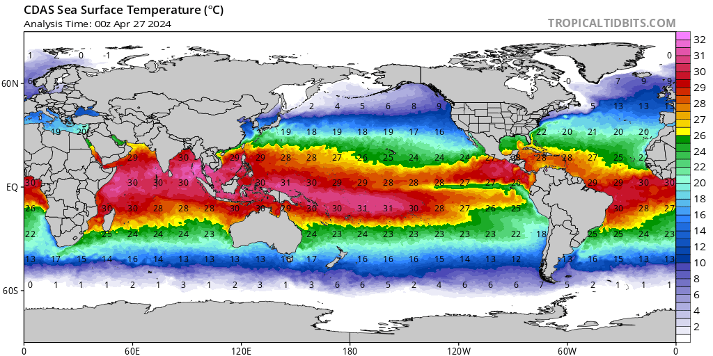
I am uncertain whether I ever recall seeing such an expansive (or any) area of 32C coverage in that part of the world. These are 90 degree F water temperatures to the north of Australia. For such an anomaly in the deep tropics, it yields a significant impact on the energy budget as you know, and concordantly, it isn't surprising to see the modeled high amplitude in phases 4/5 of the MJO. This is akin to throwing gasoline on the proverbial fire. Ambient SST's of 32C/90F are very impressive. This will further serve to enhance the MJO in its unfavorable [from E US perspective] octants.
Hobbyist question here: When you say that this pool of high-octane fuel will "enhance" the MJO in its unfavorable phases, do you mean to say that it will: (1) become more amplified as it passes through those phases; (2) spend a greater-than-usual time in those phases; or (3) both?
-
1 hour ago, forkyfork said:
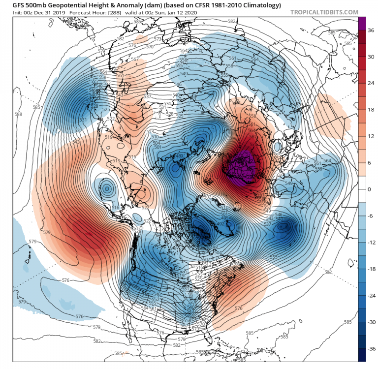
this is as bad a pattern as you can get

Squinting hard through my rose-colored glasses here, but the one thing we have on our side is that we actually have cold air on our side of the globe. Were we staring at this map with the PV trapped over in Siberia, I might be ready to waive the white flag, esp with the Pacific SSTs favoring the MJO looping in its unfavorable phases....
But the (relatively) nearby cold at least keeps alive the possibility that some elusive ATL help can rescue us at some point.
-
7 hours ago, psuhoffman said:
It’s a long shot but get that Scandinavia ridge a little west (needs to retrograde to where it’s poking into Iceland) and working in conjunction with a monster 50/50 and it can work. There was one snowstorm in the dataset of central pac ridge snows that looked like that. Most had a west based NAO block though. But that kind of Scand ridge can be a precursor to NAO blocking. As you said it’s all we got. It’s really our only way out of this mess.
7 hours ago, nj2va said:That’s what I’ve been paying attention to as well since (thanks to your research thread) and remembering something Wes (I think) talked about a few years ago, Scand ridges generally predict more favorable patterns for us even with a crap Pacific.
Forgive me if I am mis-remembering, but didn't the January 2016 storm benefit from a "bootleg block" that originated up in the Scandi/Kara region?
Like most, I am squinting hard to see some light at the end of the tunnel. The optimist in me feels good that we at least have the cold on our side of the pole. Were the PV locked up over Siberia right now, I think I'd have the towel in-hand...even up here.
Great analysis in here, as always!
-
Hugging that Scandinavia ridge showing up on the 288hr op GFS. Pretty much all I’ve got given the doom and gloom on here today.
-
1
-
 1
1
-
-
2 hours ago, bluewave said:
The ensemble means don’t have much skill beyond day 6-10. So reliable model themes start to emerge right around day 8-10. Leaning too heavily on day 11-15 model output usually ends in disappointment.
This!! So much this! I’m as anxious as anybody to get some meaningful winter weather in here, but LR modeling isn’t worth chewing on until we are inside ten days (at least)!!
-
2
-
-
2 minutes ago, psuhoffman said:
I’m willing to wait quite a bit if this is where we are heading (and there is evidence from analogs and tropical forcing not just blind hope to suggest it is).
How does this evolution compare with that of 2013-14? IIRC, we flipped cold right around New Years, (at least up here) cashed in with a storm right in the beginning of January, and remained in the freezer for at least a month and a half.
-
 1
1
-
-
Pre-Xmas storm has my interest more than anything right now, but my worry is that we tearfully watch it bomb out over the Flemish Cap. If we somehow can toss some sand in the gears of that PAC jet, things could get interesting. We deserve it after enduring last year’s garbage pattern. Got my fingers crossed!
-
3
-
-
Decent trends today, but might a cutter next week tug that TPV toward the 50/50 position which, combined with the modeled west-based -NAO, might set the table for a more interesting Xmas week?
Not looking to be invidious, but what do we think of the "sacrificial lamb" perspective?
-
Winding down in SW Suffolk. Roads are wet with slushy patches, but I measured 2.2" on the grass.
Brings me to 4.4" on the season so far. Not too bad after last year's shutout. Here's to keeping it going and hoping the leadup to Xmas has some fun in store for us!

-
2
-
-
2 minutes ago, CIK62 said:
Speaking of the LR, the latest EURO Weeklies are out and they better be wrong. Both OP and Control like it BN in the western quarter of the country, and AN elsewhere, +2F for us on the next 46 days. Christmas week did not look like a gift either. Snowfall for the 6-Week+ period looked to be 3" to 10" in and around our geographically interested fan area.
From above post:
From the hobbyist perspective, it seems like the theme of the past few years has been a general humbling of our ability to forecast general long-range weather patterns. Certainly, LR models seem to miss the mark more often in the past two years or so.(1) Is there something to this anecdote?
(2) If yes, is there some scientific basis for this? (I was thinking maybe the MJO/PAC firehose is mucking things up.)
>>>>My idea is the atmosphere is getting harder to predict faster than, the models can improve. Think of shooting at your stationary target and the rating you have obtained----what happened when they started moving the target around? You are still becoming a better shot even with the lower scores.
Felicitous choice of analogy! Posts like these are why I love these boards. Excellent convo all-around today. Thanks!!


Tropical Storm Fay
in New York City Metro
Posted
So far, I’d say “ample.”