

pondo1000
-
Posts
1,704 -
Joined
-
Last visited
Content Type
Profiles
Blogs
Forums
American Weather
Media Demo
Store
Gallery
Posts posted by pondo1000
-
-
Absolutely pouring snow in Powell right now. Snow globe. Ground covered including the street.
-
17 minutes ago, OHweather said:
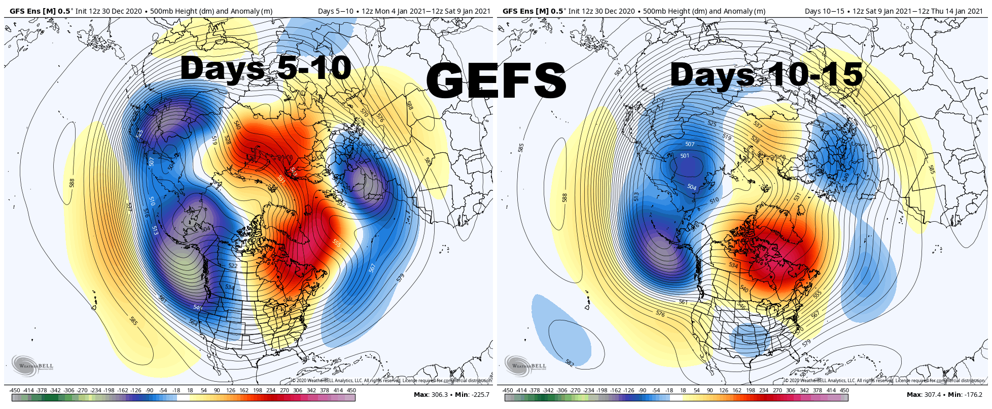
The very strong positive East Asian Mountain Torque (the very strong high pressure over eastern Asia) which is causing our strong Pacific jet stream and flood of mild air, but is also contributing to the developing strat warming event, is hinted to begin weakening in the the 7-10 day:

This causes the trough to begin retrograding across the northern Pacific as the Pacific jet begins to pull back a bit. As a result, both the GEFS and EPS begin raising heights in the 10-15 day range on the West Coast of the US and Canada:
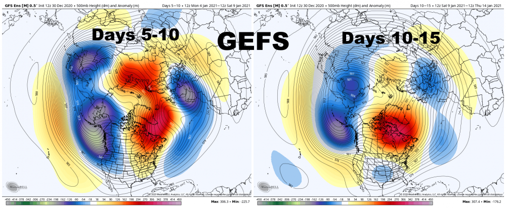
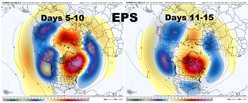
With an active sub-tropical jet and developing split flow over the western U.S., along with a persistent, west-based -NAO, this would begin increasing the risk for winter storms across the eastern and central U.S. around or just after January 10th. It would not immediately be a very cold pattern, but it could be a snowy one for some areas.
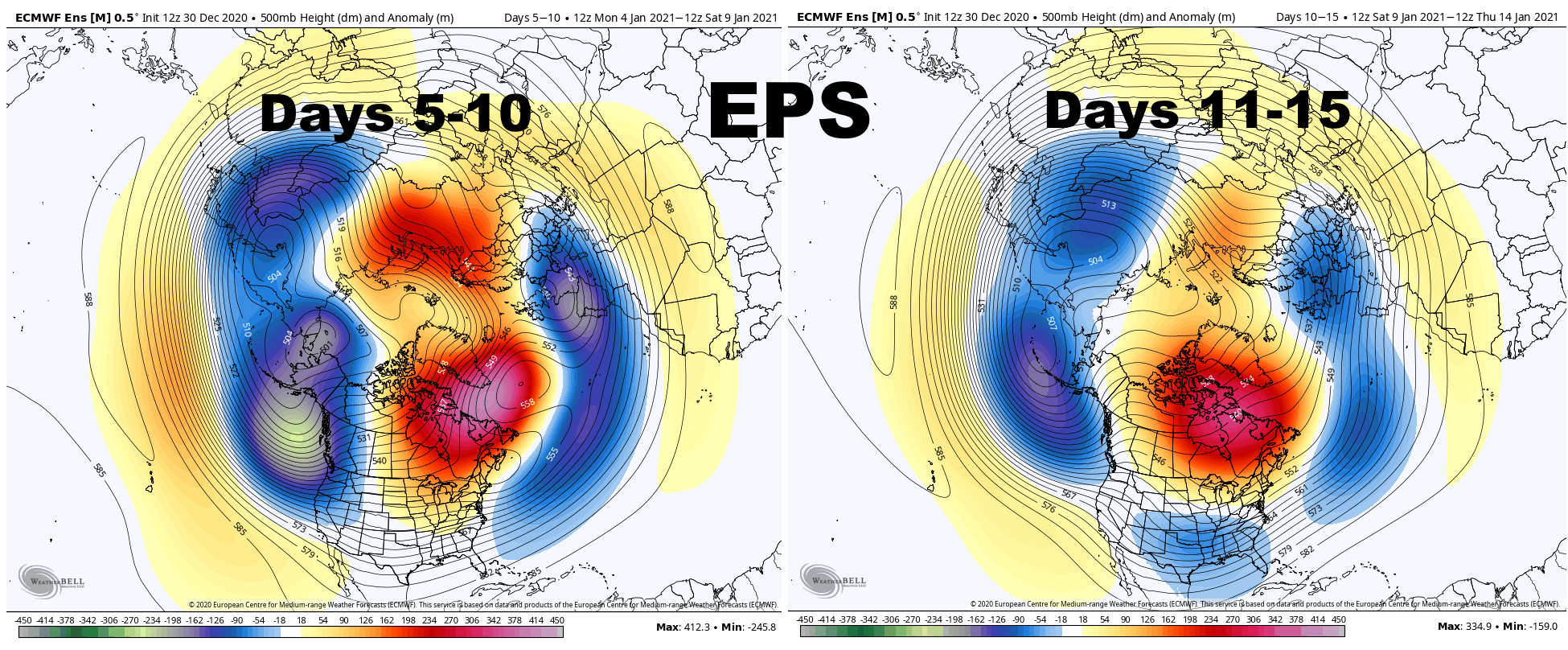
The EPS continues to retrograde the trough into northeast Asia in the 10-15 day range while the Pacific jet continues pulling back. I'm not sure this lasts long, but could give a window for ridging into Alaska after mid-month. With a split flow over the western US and continued -NAO, a window of ridging over Alaska could both introduce colder air, but also lead to a quite active pattern for the Ohio Valley and southern Great Lakes into the Northeast beginning around or just after the middle of January.
.gif.de6b65be41887373a5f8da892c5f0858.gif)
This is still a long way's out, but signs point to a better Pacific pattern soon. Given the -NAO in place slowing down any storms over the eastern 2/3rds of the CONUS, all we need is a somewhat cooperative Pacific to have some fun.
Always appreciate your knowledge & insight in LAMENS terms. Thank you!!!
-
 2
2
-
-
12 minutes ago, dilly84 said:
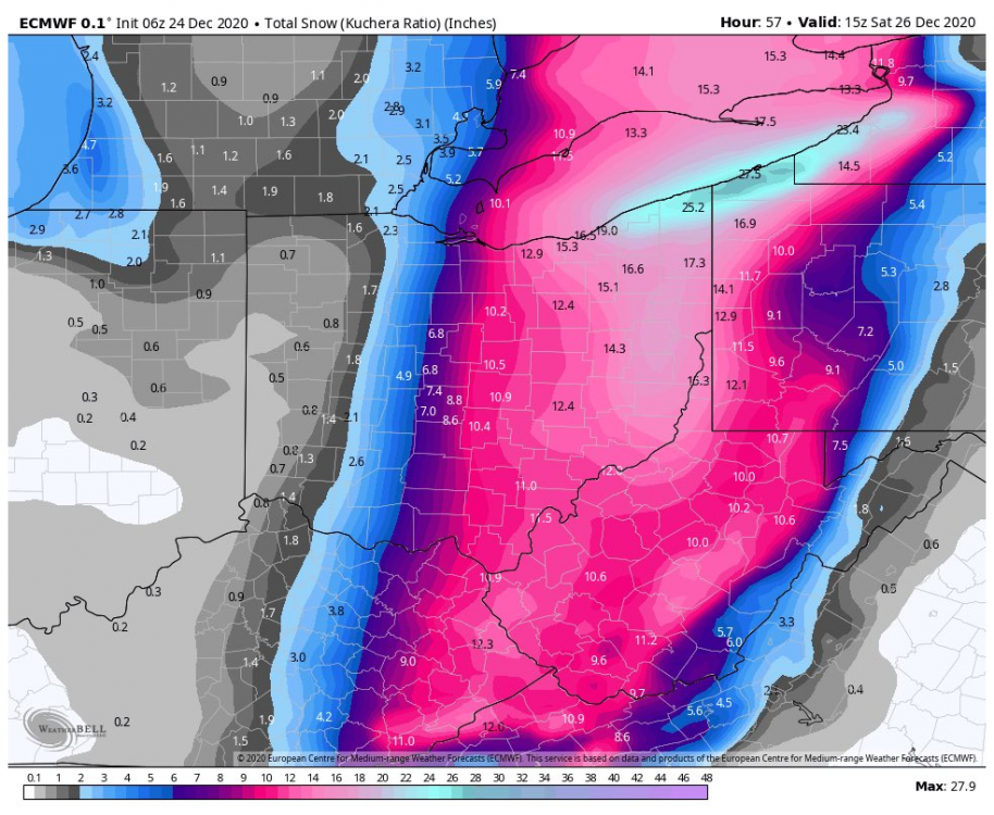
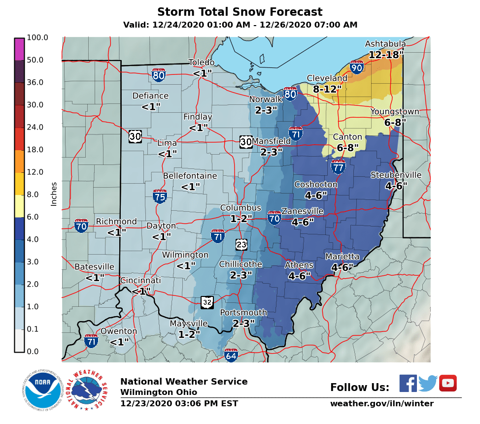
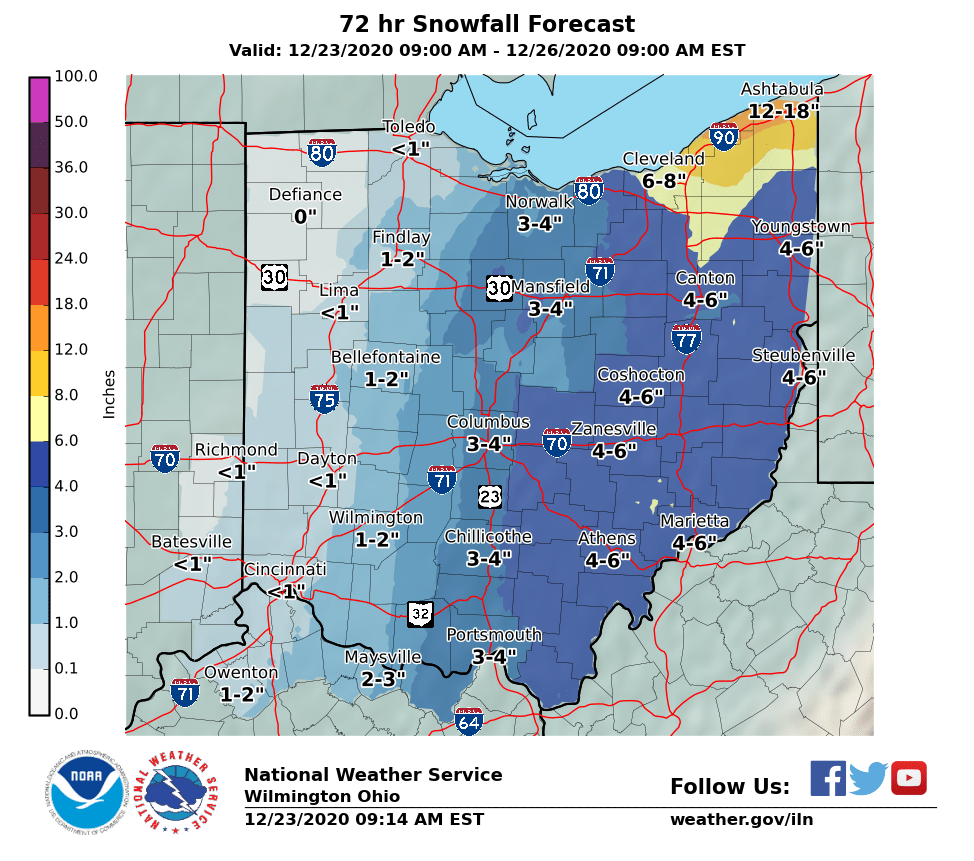
7" in knox county with probably another 3 or so to come. Pretty unbelievable. First time in my 37 years to see this on Christmas Eve/Christmas
Nice!!!
-
5 minutes ago, jbcmh81 said:
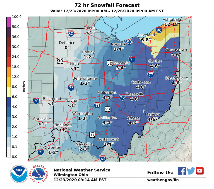
Definitely overperformed further west with places in Madison County getting 2-3" when few models had more than an inch at best. Looks like 3-5" across Columbus.
Will probably go down as the snowiest Christmas Eve in Columbus ever, which is kind of sad if you think about it.
The biggest December 24th snowfall ever before today was 2.7" in 1980. An inch or more has fallen on the date only 4 times since 1884, not including today, and not once in the 40 years since 1980.
Wow
-
5 minutes ago, Steve said:
Unfortunately no...
Christmas miracle! So rare to get actual snow like this on Christmas Eve/Day! Enjoy! Merry Christmas to everyone!!!
-
3
-
-
1 minute ago, McHenrySnow said:
Becoming pretty clear that next week is another wasted week of winter here.
Yup. Looks like the Pacific is in control.
-
20 minutes ago, Gino27 said:
Well... there's this. Idk if I've laughed this hard in a while.
Is that 6z Euro?
Sorry. See it now.
-
2 hours ago, Steve said:
Looking at the radar and trying to figure out where our snow is going to come from....
LOL. With the front. I’m not expecting more than a few flurries/snow showers
-
10 minutes ago, OrdIowPitMsp said:
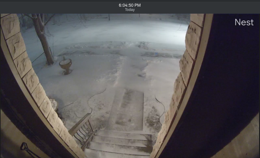
Front shot. As you can see roads are completely snow packed. Shoveled the front walk and sidewalk a few minutes prior and already drifting back over.
Enjoy!
-
Just now, Gino27 said:

I spoke too soon. <1" for me now...
Just seems to be the trend for the last several years when there’s a chance for anything. So bad.
-
 1
1
-
-
8 minutes ago, WHEATCENT said:
Ouch
-
10 minutes ago, Gino27 said:
Didn't expect to see this given the latest model suite, but I'd gladly take this.
U ain’t kidding. One time, just one time, a little Christmas miracle please! LOL
-
1
-
-
2 minutes ago, Gino27 said:
Same here. Kuchera casually drops 10" here lol
Hah, if only!
-
1 minute ago, StormfanaticInd said:
Canadian model
Ahh, thank u!!!
-
1
-
-
Just now, StormfanaticInd said:


What model is the GDPS?
-
31 minutes ago, Gino27 said:
Just chillin on the edge.
I could live with 2-3 for xmas & some sledding w/ the kids the days after.
-
1
-
-
11 minutes ago, Gino27 said:
Right in between Dublin and Marysville. It's technically Plain City. It's gonna be a razor thin cut off I'm afraid.
Cool. I work with someone from Plain City. Here’s hoping for a westward jog. LOL
-
1 minute ago, Gino27 said:
Looks decent for you in Mt. Vernon. Painfully close for me. Euro wants to keep that snow in the general area for about 9 hours.
You are in Marysville right? I’m in Powell so a tad southeast of you.
-
1 minute ago, Frog Town said:

Did the years get cut off in the last set?
-
7 minutes ago, Frog Town said:
But when they do, they DO
When DO they?
-
1 minute ago, StormfanaticInd said:
Always 15 days away. These never pan out.
-
2
-
 1
1
-
-
10 hours ago, Gino27 said:
There's some nice things to like about it, mostly the very very cold air it has to work with. I worry it'll be too fast and a bit too warm. Hopefully we can get the trough to go negative a bit earlier like models had, and might be trending to.
Nice rainer again xmas eve!!!
-
4 minutes ago, Steve said:
Really didn’t want to bring it up yet.... but next Thursday through Christmas Day definitely has my attention!! Cold front passage plus a storm riding it... would be nice..
Trending west with the storm b/c up to this point been too far east no?
-
17 minutes ago, jbcmh81 said:
Live view - AXIS Q6044-E Network Camera (osu.edu)
Nice little event for most of Columbus it seems.
The light stuff in Indy popping up going to survive the trip out here?


Winter 2020-21 Medium/Long Range Discussion
in Lakes/Ohio Valley
Posted
For east coast for sure. Not sure about for us yet.