

pondo1000
-
Posts
1,704 -
Joined
-
Last visited
Content Type
Profiles
Blogs
Forums
American Weather
Media Demo
Store
Gallery
Posts posted by pondo1000
-
-
25 minutes ago, jaf316 said:
12z euro says 6+ inches in cbus by Monday night. I'll take it!
Let’s hope
-
31 minutes ago, Gino27 said:
I'm on the very eastern fringe of the watch. Calling for 5-8. Anything over 6" would be my biggest storm in almost 6 years.
ILN will probably hoist watches up late this afternoon. Just my opinion.
-
-
1 minute ago, mimillman said:
10:1

Gotta love NAM clown maps!!!
-
 2
2
-
-
16 minutes ago, pondo1000 said:
What did it show? And yes, you are right about that which is why it is still quiet in here & will be until it starts actually snowing! LOL
Never mind. Saw it in another thread. If only.......
-
4 minutes ago, Gino27 said:
18z euro showing something we don't see around here often. I have my doubts per usual. These love to get swept out from under us in the last 48 hours.
What did it show? And yes, you are right about that which is why it is still quiet in here & will be until it starts actually snowing! LOL
-
1
-
-
5 minutes ago, Gino27 said:
I'm trying to be very cautious with this. We've seen these trend north and go warm within 48 hours a million times.
Hard to get excited for sure b/c of all the let downs around here. I believe an old friend (Buckeye) used to say that we can do well with these types of setups with the front end thump. Fingers crossed!
-
3 minutes ago, Steve said:
Wake up!! Sunday and Mondays storm could impact Ohio...could be a nice dump of snow..
Everyone knows the deal around here. LOL Maybe we can score on this one, especially that front end thump.
-
32 minutes ago, Baum said:
Will we ever have another 7-10 day clipper train period?
Miss those days. Been years.
-
1
-
-
2 minutes ago, Gino27 said:
Yeah for sure. 1/19/19 looked like an easy 8"-12" north of I-70. I got 6" with 1.4" of liquid that day. What could've been....
I'm pretty sure the last warning before that verified would've been 3/1/2015 with a WSW upgrade during the storm, and the 2/1/19 clipper got close to warning criteria with high ratios. However, he last true watch turned warning that met criteria was 2/21/15. That's 2,166 days. ugh...
That is unreal! I knew it felt longer.
-
1
-
-
13 minutes ago, Gino27 said:
I put this out on Sunday. Make it 738 days.
Got ya. Thx! I have zero recollection of that one in 2019. Must have been a doozy! LOL
-
1
-
-
1 hour ago, Steve said:
This weekend could be interesting.... could we finally break this boring 4 week snow drought?
Indeed. Does anyone know or can find out the last time we had a Winter Storm Warning in central OH? I know we’ve had Watches but I think it may be 2015/16 since we had a Warning.
-
5 minutes ago, KokomoWX said:
Best chance we have had all year!
Cool. Never seen that map before. Thx
-
Been a shitty winter. Think it’s been since 2014 that we have had a Winter Storm Warning here. Ugh.
-
5 minutes ago, SchaumburgStormer said:
Or it can still be south, just slightly less so.
So north of south then.
-
11 minutes ago, CheeselandSkies said:
Why can't the Euro be king anymore?
This could be its redemption.
-
 1
1
-
-
31 minutes ago, Frog Town said:
I think I'm suffering from zzzzzzzzzzzzzzzzzzzzzzzzzzzzz fatigue. Anyone else feeling this?
Yes & never have ur zzzzzzz’s lasted this long. Truly. What a crap fest!
-
Snow globe here! Starting to stick to grass.
-
9 minutes ago, Baum said:
^ I'll bank on 12
Greedy SOB! LOL!
-
1
-
-
46 minutes ago, StormfanaticInd said:
Cold is coming

Hopefully we at least get “some” snow with it!
-
5 minutes ago, Spartman said:
Delayed, delayed, delayed. Not a good sign.
-
17 minutes ago, Frog Town said:
For those of us that can't see it, is there sarcasm attached to it??
Pretty sure it’s sarcasm.
-
1
-
-
16 minutes ago, Snowstorms said:
Strong easterlies have dominated across the ENSO region primarily near the dateline and are expected to continue past mid-Jan which has driven the SOI to 2010-11 levels. So yes, for the moment it's expected to strengthen. Subsurface anomalies continue to remain cold. Wouldn't be surprised to see a second peak.
Thus far, the La Nina hasn't fully coupled with the atmosphere but there's growing evidence the ridge building across the west will slowly retrograde towards the Aleutians come February, which is more typical of a Nina. Global AAM has finally gone negative so we’ll see if that holds over the next few weeks. February is certainly going to be a strong gradient month with the La Nina fighting to take control of the pattern and impressive polar blocking. Feeling optimistic about February, it could be our best month.
Thank you!!!
-
1
-
-
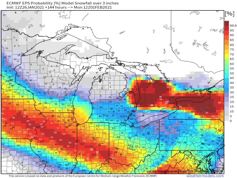
Anyone see the latest with La Nina? Heard murmurs it was strengthening?
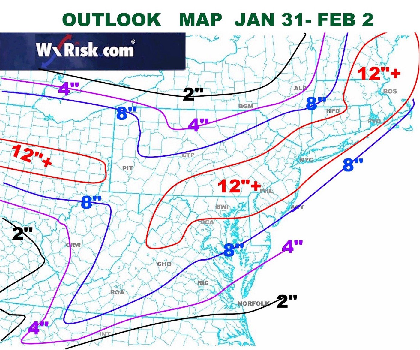
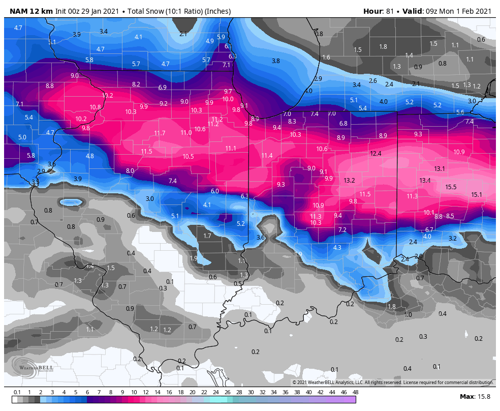

January 30-February 1 Winter Storm
in Lakes/Ohio Valley
Posted
ILN dropping what watches? I didn’t see any watches from them?