meatwad
-
Posts
1,919 -
Joined
-
Last visited
Content Type
Profiles
Blogs
Forums
American Weather
Media Demo
Store
Gallery
Everything posted by meatwad
-

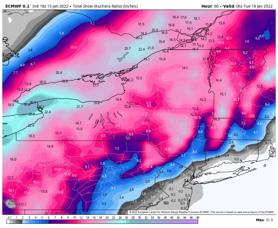
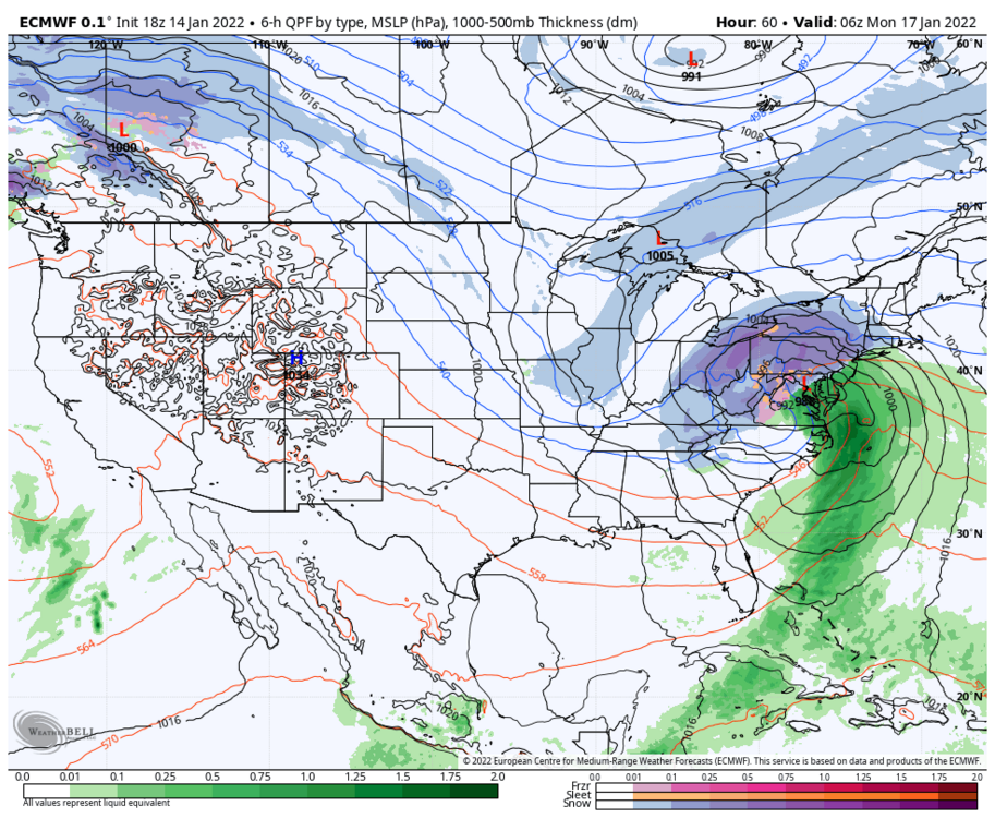
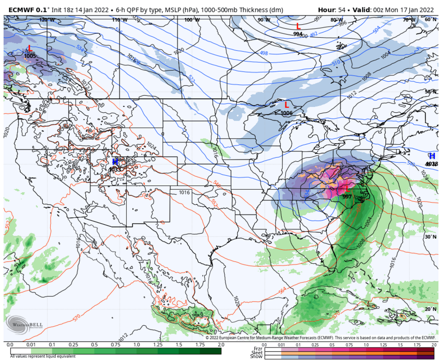
Western PA/Pittsburgh Winter 2021/22 Discussion
meatwad replied to meatwad's topic in Upstate New York/Pennsylvania
Agc, autocorrect goes to age for some reason . -
Western PA/Pittsburgh Winter 2021/22 Discussion
meatwad replied to meatwad's topic in Upstate New York/Pennsylvania
Down to 15 at age and pit -
Western PA/Pittsburgh Winter 2021/22 Discussion
meatwad replied to meatwad's topic in Upstate New York/Pennsylvania
-
Western PA/Pittsburgh Winter 2021/22 Discussion
meatwad replied to meatwad's topic in Upstate New York/Pennsylvania
-
Western PA/Pittsburgh Winter 2021/22 Discussion
meatwad replied to meatwad's topic in Upstate New York/Pennsylvania
-
Western PA/Pittsburgh Winter 2021/22 Discussion
meatwad replied to meatwad's topic in Upstate New York/Pennsylvania
That was a great storm -
Western PA/Pittsburgh Winter 2021/22 Discussion
meatwad replied to meatwad's topic in Upstate New York/Pennsylvania
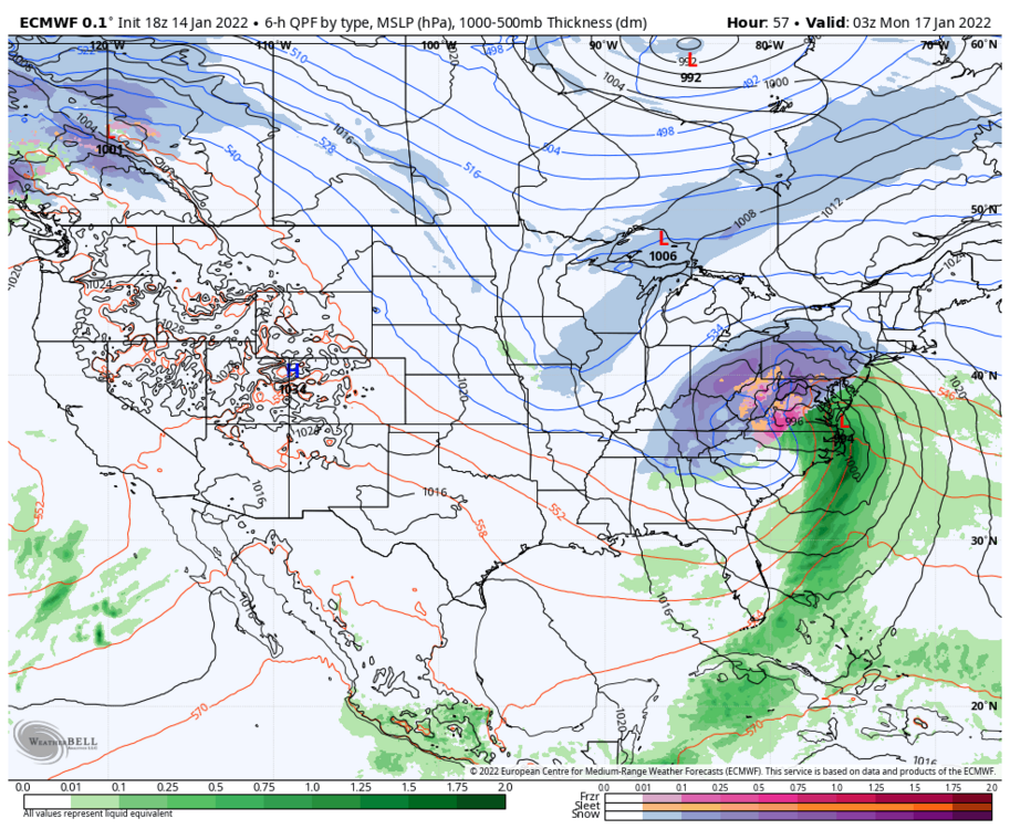
The rgem looks solid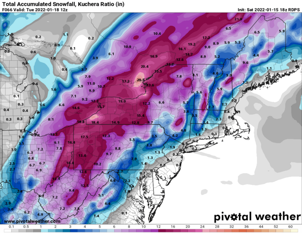
-
Western PA/Pittsburgh Winter 2021/22 Discussion
meatwad replied to meatwad's topic in Upstate New York/Pennsylvania
Colder than expected today -
Western PA/Pittsburgh Winter 2021/22 Discussion
meatwad replied to meatwad's topic in Upstate New York/Pennsylvania
-
Western PA/Pittsburgh Winter 2021/22 Discussion
meatwad replied to meatwad's topic in Upstate New York/Pennsylvania
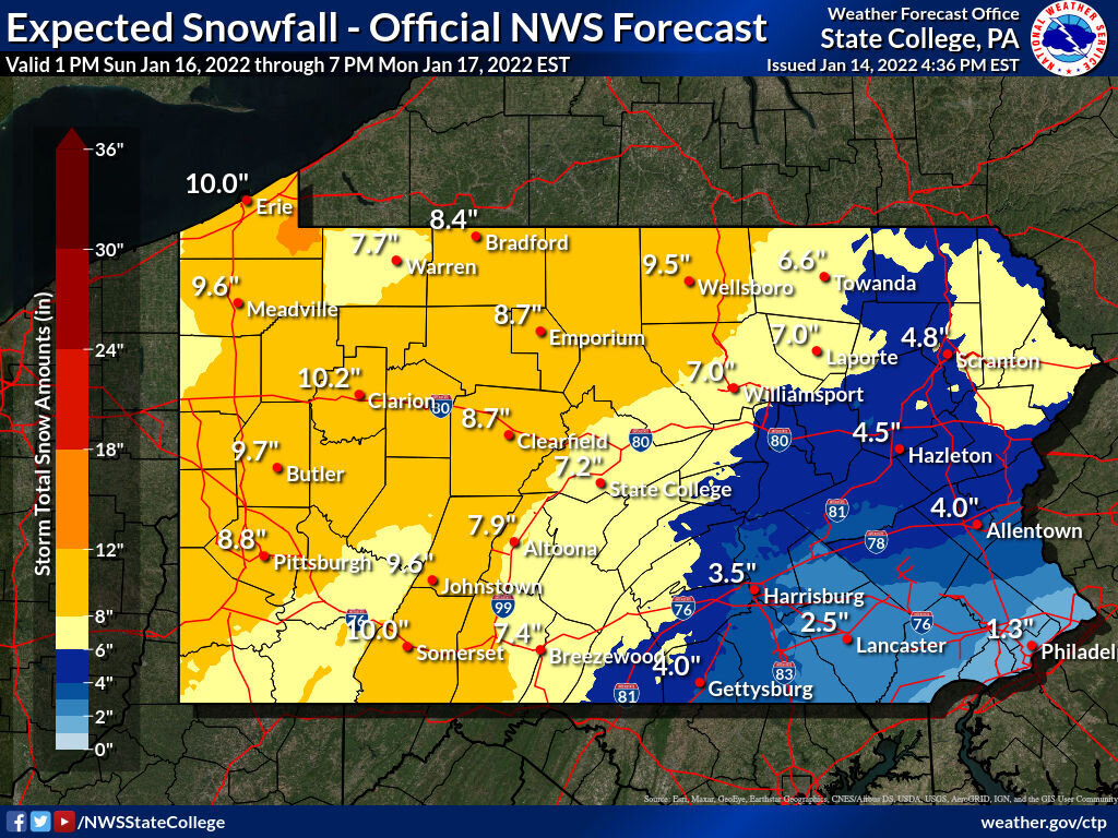
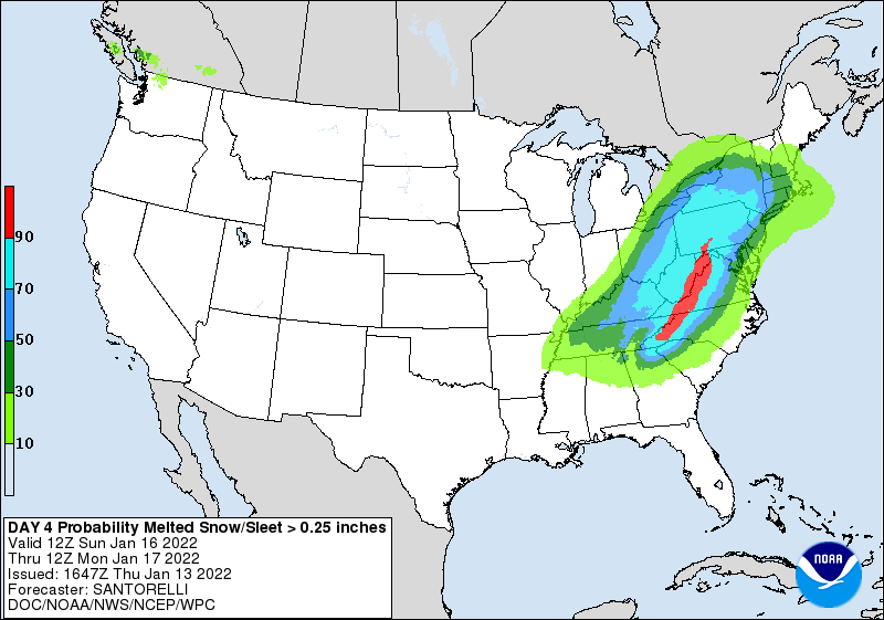
URGENT - WINTER WEATHER MESSAGE National Weather Service Pittsburgh PA 1233 PM EST Sat Jan 15 2022 OHZ039>041-048>050-057>059-068-069-PAZ007>009-013>016-020>023-029- 031-073>076-WVZ001>004-012-021-509>514-160145- /O.UPG.KPBZ.WS.A.0001.220116T1800Z-220117T1800Z/ /O.NEW.KPBZ.WS.W.0002.220116T1800Z-220117T1800Z/ Tuscarawas-Carroll-Columbiana-Coshocton-Harrison-Jefferson OH- Muskingum-Guernsey-Belmont-Noble-Monroe-Mercer-Venango-Forest- Lawrence-Butler-Clarion-Jefferson PA-Beaver-Allegheny-Armstrong- Indiana-Washington-Greene-Westmoreland-Higher Elevations of Westmoreland-Fayette-Higher Elevations of Fayette-Hancock-Brooke- Ohio-Marshall-Wetzel-Marion-Monongalia-Ridges of Eastern Monongalia and Northwestern Preston-Preston-Eastern Preston- Western Tucker-Eastern Tucker- Including the cities of Sharon, Parsons, Canonsburg, Thomas, New Kensington, Punxsutawney, Caldwell, Pittsburgh Metro Area, New Martinsville, Greensburg, Hendricks, Steubenville, Ligonier, Indiana, Butler, Beaver Falls, Aliquippa, Bruceton Mills, Coshocton, Terra Alta, Champion, Hermitage, Coopers Rock, Grove City, Murrysville, Weirton, St. Clairsville, Rowlesburg, Tionesta, Carrollton, Kittanning, Woodsfield, Moundsville, Malvern, Ford City, Morgantown, Ohiopyle, Ambridge, Kingwood, Hazelton, Cadiz, Oil City, Clarion, Uniontown, Latrobe, Ellwood City, Monessen, Columbiana, Canaan Valley, East Liverpool, Davis, Monaca, Wheeling, Wellsburg, Dover, New Castle, Lower Burrell, Cambridge, Saint George, Donegal, Zanesville, New Philadelphia, Washington, Waynesburg, Fairmont, Martins Ferry, Salem, Brookville, Follansbee, and Franklin 1233 PM EST Sat Jan 15 2022 ...WINTER STORM WARNING IN EFFECT FROM 1 PM SUNDAY TO 1 PM EST MONDAY... * WHAT...Heavy snow expected. Total snow accumulations between 6 and 11 inches. * WHERE...Portions of east central Ohio. Portions of northwest, southwest, and western Pennsylvania. Portions of northern and the northern panhandle of West Virginia. * WHEN...From 1 PM Sunday to 1 PM EST Monday. * IMPACTS...Roads, and especially bridges and overpasses, will likely become slick and hazardous. Travel could be very difficult. The hazardous conditions could impact the Monday morning commute. PRECAUTIONARY/PREPAREDNESS ACTIONS... If you must travel, keep an extra flashlight, food, and water in your vehicle in case of an emergency. The latest road conditions for the state you are calling from can be obtained by calling 5 1 1. Persons should delay all travel if possible. If travel is absolutely necessary, drive with extreme caution and be prepared for sudden changes in visibility. Leave plenty of room between you and the motorist ahead of you, and allow extra time to reach your destination. Avoid sudden braking or acceleration, and be especially cautious on hills or when making turns. Make sure your car is winterized and in good working order. Dangerous conditions are expected along Interstate 80 for the next several hours. Remember, `Pull Aside, Stay Alive`. && $$ JL -
Western PA/Pittsburgh Winter 2021/22 Discussion
meatwad replied to meatwad's topic in Upstate New York/Pennsylvania
-
Western PA/Pittsburgh Winter 2021/22 Discussion
meatwad replied to meatwad's topic in Upstate New York/Pennsylvania
Looks good -
Western PA/Pittsburgh Winter 2021/22 Discussion
meatwad replied to meatwad's topic in Upstate New York/Pennsylvania
-
Western PA/Pittsburgh Winter 2021/22 Discussion
meatwad replied to meatwad's topic in Upstate New York/Pennsylvania
-
Amwx hug of death
-
Western PA/Pittsburgh Winter 2021/22 Discussion
meatwad replied to meatwad's topic in Upstate New York/Pennsylvania

-
Western PA/Pittsburgh Winter 2021/22 Discussion
meatwad replied to meatwad's topic in Upstate New York/Pennsylvania
-
Western PA/Pittsburgh Winter 2021/22 Discussion
meatwad replied to meatwad's topic in Upstate New York/Pennsylvania
-
Western PA/Pittsburgh Winter 2021/22 Discussion
meatwad replied to meatwad's topic in Upstate New York/Pennsylvania
-
Western PA/Pittsburgh Winter 2021/22 Discussion
meatwad replied to meatwad's topic in Upstate New York/Pennsylvania
-
Western PA/Pittsburgh Winter 2021/22 Discussion
meatwad replied to meatwad's topic in Upstate New York/Pennsylvania
GEM looks good -
Western PA/Pittsburgh Winter 2021/22 Discussion
meatwad replied to meatwad's topic in Upstate New York/Pennsylvania
-
Western PA/Pittsburgh Winter 2021/22 Discussion
meatwad replied to meatwad's topic in Upstate New York/Pennsylvania
-
Western PA/Pittsburgh Winter 2021/22 Discussion
meatwad replied to meatwad's topic in Upstate New York/Pennsylvania
Yeah it’s weird -
Western PA/Pittsburgh Winter 2021/22 Discussion
meatwad replied to meatwad's topic in Upstate New York/Pennsylvania
Euro looks good, I think.