

meatwad
-
Posts
1,919 -
Joined
-
Last visited
Content Type
Profiles
Blogs
Forums
American Weather
Media Demo
Store
Gallery
Everything posted by meatwad
-

Western PA/Pittsburgh Winter 2021/22 Discussion
meatwad replied to meatwad's topic in Upstate New York/Pennsylvania
Anafront snows? -
Western PA/Pittsburgh Winter 2021/22 Discussion
meatwad replied to meatwad's topic in Upstate New York/Pennsylvania
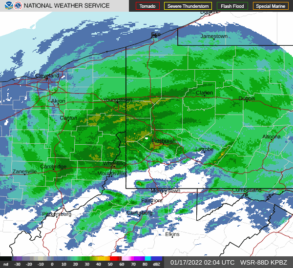
000 FXUS61 KPBZ 171302 AFDPBZ Area Forecast Discussion National Weather Service Pittsburgh PA 802 AM EST Mon Jan 17 2022 .SYNOPSIS... Low pressure moving across the Mid-Atlantic region will result in continued snowfall today. Afterward, cold weather will persist all week long with intermittent snow chances. && .NEAR TERM /THROUGH TONIGHT/... Frontogenesis and vorticity advection are still very much present and contributing to overall ascent on the back side of this eastward propagating trough. As evident per 12Z KPIT sounding, much colder air, nw flow has initiated with a saturated profile. Snowfall will continue to accumulate, heavily at times, depending on location and enhancement within frontogenesis. An additional 2-3 inches is generally possible, especially north of Pittsburgh. Several more inches are likely in the higher elevations as upslope will be favored. Sustained wind speed and gusts will increase in the higher terrain of the WV and PA Alleghenies on Monday, which will likely result in blowing snow and lowered visibility. && .SHORT TERM /TUESDAY THROUGH TUESDAY NIGHT/... Tonight, coverage in snow showers will gradually taper off, though isolated snow showers will remain with lake enhancement of lingering vorticity advection and upslope. Light accumulation is possible Tuesday morning in the WV ridges and Laurel Mountains. Tuesday day will be cold and mostly cloudy, with a cloud deck attempting to erode from the south through the day. Look for highs in the upper 20s to low 30s. && .LONG TERM /WEDNESDAY THROUGH SUNDAY/... Low pressure propagating sewd across the Great Lakes will provide the chance for precipitation on Monday, with likely a frontal passage that could result in progressive precip chances of rain/snow mix. Long range model ensembles indicate that a cold stretch is likely, with low temperature progged in the single digits on Thursday and Friday nights. && .AVIATION /13Z MONDAY THROUGH FRIDAY/... IFR with periods of low-MVFR and LIFR will persist through the morning as a low pressure system moves northward across the Mid- Atlantic. The most significant restrictions will occur in a deformation snow band as it pivots across just about all area terminals, with likely sub-1SM vis and CIGs under 1kft. With the exception of ZZV, terminals should receive a few inches of additional snowfall accumulation. Cold northwest flow on the backside of the low as it departs will result in continued MVFR CIGs with scattered lake-enhanced snow showers. These showers will gradually taper off Monday night into Tuesday with CIGs gradually breaking up in response to incoming dry air. .Outlook... Widespread VFR conditions are likely to return mid day Tuesday under building high pressure. && .PBZ WATCHES/WARNINGS/ADVISORIES... PA...Winter Storm Warning until 1 PM EST this afternoon for PAZ007>009- 013>016-020>023-029-031-073>076. OH...Winter Storm Warning until 1 PM EST this afternoon for OHZ039>041- 048>050-057>059-068-069. WV...Winter Storm Warning until 1 PM EST this afternoon for WVZ001>004- 012-021-509>514. && $$ -
Western PA/Pittsburgh Winter 2021/22 Discussion
meatwad replied to meatwad's topic in Upstate New York/Pennsylvania
Still snowing this morning. The radar still looks good. -
Western PA/Pittsburgh Winter 2021/22 Discussion
meatwad replied to meatwad's topic in Upstate New York/Pennsylvania
Snowing again as well, -
Western PA/Pittsburgh Winter 2021/22 Discussion
meatwad replied to meatwad's topic in Upstate New York/Pennsylvania
Freezing rain here -
Western PA/Pittsburgh Winter 2021/22 Discussion
meatwad replied to meatwad's topic in Upstate New York/Pennsylvania
-
Western PA/Pittsburgh Winter 2021/22 Discussion
meatwad replied to meatwad's topic in Upstate New York/Pennsylvania
Looks like the radar is filling in a bit. -
Western PA/Pittsburgh Winter 2021/22 Discussion
meatwad replied to meatwad's topic in Upstate New York/Pennsylvania
Stopped snowing for now. -
Western PA/Pittsburgh Winter 2021/22 Discussion
meatwad replied to meatwad's topic in Upstate New York/Pennsylvania
Still heavy snow here. -
Western PA/Pittsburgh Winter 2021/22 Discussion
meatwad replied to meatwad's topic in Upstate New York/Pennsylvania
Extremely heavy snow now -
Western PA/Pittsburgh Winter 2021/22 Discussion
meatwad replied to meatwad's topic in Upstate New York/Pennsylvania
Ripping pretty good here. -
Western PA/Pittsburgh Winter 2021/22 Discussion
meatwad replied to meatwad's topic in Upstate New York/Pennsylvania
Back to heavy snow. -
Western PA/Pittsburgh Winter 2021/22 Discussion
meatwad replied to meatwad's topic in Upstate New York/Pennsylvania
Snow and sleet again here -
Western PA/Pittsburgh Winter 2021/22 Discussion
meatwad replied to meatwad's topic in Upstate New York/Pennsylvania
Puking snow now. -
Western PA/Pittsburgh Winter 2021/22 Discussion
meatwad replied to meatwad's topic in Upstate New York/Pennsylvania
Back to all snow in Monroeville. -
Western PA/Pittsburgh Winter 2021/22 Discussion
meatwad replied to meatwad's topic in Upstate New York/Pennsylvania
What a weird storm -
Western PA/Pittsburgh Winter 2021/22 Discussion
meatwad replied to meatwad's topic in Upstate New York/Pennsylvania
More snow now, some sleet mixed in -
Western PA/Pittsburgh Winter 2021/22 Discussion
meatwad replied to meatwad's topic in Upstate New York/Pennsylvania
Sleet and freezing rain and snow now -
Western PA/Pittsburgh Winter 2021/22 Discussion
meatwad replied to meatwad's topic in Upstate New York/Pennsylvania
Moderate snow here now. -
Western PA/Pittsburgh Winter 2021/22 Discussion
meatwad replied to meatwad's topic in Upstate New York/Pennsylvania
Dynamic cooling ftw. -
Western PA/Pittsburgh Winter 2021/22 Discussion
meatwad replied to meatwad's topic in Upstate New York/Pennsylvania
Decent snow here in Monroeville, wish the Steelers were in hienz field tonight. -
Western PA/Pittsburgh Winter 2021/22 Discussion
meatwad replied to meatwad's topic in Upstate New York/Pennsylvania
Dyanamic cooling ? -
Western PA/Pittsburgh Winter 2021/22 Discussion
meatwad replied to meatwad's topic in Upstate New York/Pennsylvania
At least i95 is not gonna get hardly any snow today. -
Western PA/Pittsburgh Winter 2021/22 Discussion
meatwad replied to meatwad's topic in Upstate New York/Pennsylvania
-
Western PA/Pittsburgh Winter 2021/22 Discussion
meatwad replied to meatwad's topic in Upstate New York/Pennsylvania

