

meatwad
-
Posts
1,919 -
Joined
-
Last visited
Content Type
Profiles
Blogs
Forums
American Weather
Media Demo
Store
Gallery
Everything posted by meatwad
-

Fall 2022 Pittsburgh/Western PA Discussion
meatwad replied to Ahoff's topic in Upstate New York/Pennsylvania
Snow Squall Warning SNOW SQUALL WARNING NWS PITTSBURGH PA 1230 PM EST FRI NOV 18 2022 OHC081-PAC003-007-019-125-WVC009-029-069-181815- /O.NEW.KPBZ.SQ.W.0004.221118T1730Z-221118T1815Z/ 1230 PM EST FRI NOV 18 2022 Jefferson County OH-Allegheny County PA-Beaver County PA-Butler County PA-Washington County PA-Brooke County WV-Hancock County WV-Ohio County WV- The National Weather Service in Pittsburgh has issued a * Snow Squall Warning for... Eastern Jefferson County in east central Ohio... Beaver County in western Pennsylvania... Northwestern Washington County in southwestern Pennsylvania... Southwestern Butler County in west central Pennsylvania... Northwestern Allegheny County in southwestern Pennsylvania... Ohio County in northern West Virginia... Brooke County in northern West Virginia... Hancock County in northern West Virginia... * Until 115 PM EST. * At 1229 PM EST, a dangerous snow squall was located along a line extending from near Cranberry to near Shippingport to Follansbee, moving east at 35 mph. HAZARD...Intense bursts of heavy snow and gusty winds leading to blowing snow and rapidly falling visibility. SOURCE...Radar indicated. IMPACT...Travel will become difficult and potentially dangerous within minutes. This includes the following highways... Pennsylvania Turnpike between mile markers 15 and 39. Interstate 79 in Pennsylvania between mile markers 62 and 92. Parkway North between mile markers 8 and 13. Interstate 376 in Pennsylvania between mile markers 33 and 62. Locations impacted include... Ross Township, McCandless Township, Cranberry, Moon Township, Weirton, Steubenville, Franklin Park, Aliquippa, Beaver Falls, Monaca, Wellsburg, and Avella. PRECAUTIONARY/PREPAREDNESS ACTIONS... Reduce speed and turn on headlights! During snow squalls, the visibility may suddenly drop to near zero in whiteout conditions. LAT...LON 4087 8010 4084 7987 4066 7989 4048 8009 4017 8033 4019 8080 4044 8077 4065 8050 4080 8030 4087 8010 -
Fall 2022 Pittsburgh/Western PA Discussion
meatwad replied to Ahoff's topic in Upstate New York/Pennsylvania
From the cpa thread -
Fall 2022 Pittsburgh/Western PA Discussion
meatwad replied to Ahoff's topic in Upstate New York/Pennsylvania
Coming down good here as well. -
Fall 2022 Pittsburgh/Western PA Discussion
meatwad replied to Ahoff's topic in Upstate New York/Pennsylvania
000 SXUS71 KPBZ 120636 RRA RERPIT RECORD EVENT REPORT NATIONAL WEATHER SERVICE PITTSBURGH PA 0134 AM EST SAT NOV 12 2022 ...RECORD DAILY MAXIMUM RAINFALL SET AT PITTSBURGH PA... A RECORD RAINFALL OF 2.36 WAS SET AT PITTSBURGH PA YESTERDAY. THIS BREAKS THE OLD RECORD OF 0.72 SET IN 1983. $$ -
Fall 2022 Pittsburgh/Western PA Discussion
meatwad replied to Ahoff's topic in Upstate New York/Pennsylvania
000 FXUS61 KPBZ 092311 AFDPBZ Area Forecast Discussion National Weather Service Pittsburgh PA 611 PM EST Wed Nov 9 2022 .SYNOPSIS... Dry conditions will continue through Thursday as high pressure remains in control. Heavy rainfall is possible Friday as tropical moisture from Nicole interacts with an approaching cold front. Much colder temperatures are forecast this weekend. && .NEAR TERM /UNTIL 6 AM THURSDAY MORNING/... Strong upper high over VA around 590 dm with 270 dm anomally over SW Ontario continues to keep mild and dry airmass over Upper Ohio Valley. Surface 1035 mb high over southern New England has a sharp ridge that extends back along the east slope of Appalachians. Dew points in the teens and 20s expected to gradually rise overnight about 10F as noctural decoupling reduces mixing from very dry air aloft. South to southeast flow and weak warm advection will result in milder overnight lows than last night. && .SHORT TERM /6 AM THURSDAY MORNING THROUGH FRIDAY NIGHT/... High pressure still in control Thursday with a warming trend in temperatures as ridging shifts eastward across the area. Thursday night, subtropical storm Nicole will begin to bring moisture into the Ohio Valley, coincident with a Great Lakes low pressure`s cold front. Moderate to heavy rainfall will be possible early Friday morning and throughout the day with between 1.75" to 2.75" currently forecast across the region. Compounding the heavy rainfall through is the parched ground that may not be quite as receptive to heavy rainfall. As well, heavy leaf fall may clog drains in urban areas. && .LONG TERM /SATURDAY THROUGH WEDNESDAY/... By Saturday, high pressure will attempt to nose into the region from the southwest. However, low level west to northwest flow off of the lake will begin to initiate some showers off the lake. By Saturday night into Sunday, the core of the colder air will move into the Upper OH Valley with 850 temps around -8 to -10 Celsius. A post frontal trough will assist in the productions of some snow showers across the northern counties Saturday night through the day on Sunday. The potential for snow showers will persist through the day on Monday until finally, surface high further infiltrates from the west cutting off the flow off the lake with dry conditions and cooler than normal temperatures in place. && .AVIATION /23Z WEDNESDAY THROUGH MONDAY/... VFR with light SSE wind is expected through the TAF period under a ridge of high pressure. .OUTLOOK.... Restrictions in rain are expected to overspread the region from S-N as low pressure, the remnants of tropical system Nicole, tracks from the SE CONUS to the Upper Ohio Valley region late Thu night through Fri eve. The low will also phase with a crossing cold front. Cig restrictions are likely through Mon under subsequent upper troughing and cold W-NW flow. && .PBZ WATCHES/WARNINGS/ADVISORIES... PA...None. OH...None. WV...None. && $$ SYNOPSIS... NEAR TERM... SHORT TERM...Craven LONG TERM... AVIATION...07 Looks like we could get 1.75 to 2.75" of rain, only if it was in the teens and 20s. -
Fall 2022 Pittsburgh/Western PA Discussion
meatwad replied to Ahoff's topic in Upstate New York/Pennsylvania
URGENT - WEATHER MESSAGE National Weather Service Pittsburgh PA 1138 AM EDT Wed Oct 19 2022 OHZ039>041-048>050-057>059-068-069-PAZ007>009-013>016-020>023-029- 031-073>076-WVZ001>004-012-021-509>512-192345- /O.UPG.KPBZ.FZ.A.0003.221020T0300Z-221020T1400Z/ /O.NEW.KPBZ.FZ.W.0006.221020T0600Z-221020T1400Z/ Tuscarawas-Carroll-Columbiana-Coshocton-Harrison-Jefferson OH- Muskingum-Guernsey-Belmont-Noble-Monroe-Mercer-Venango-Forest- Lawrence-Butler-Clarion-Jefferson PA-Beaver-Allegheny-Armstrong- Indiana-Washington-Greene-Westmoreland- Higher Elevations of Westmoreland-Fayette- Higher Elevations of Fayette-Hancock-Brooke-Ohio-Marshall-Wetzel- Marion-Monongalia- Ridges of Eastern Monongalia and Northwestern Preston-Preston- Eastern Preston- Including the cities of New Philadelphia, Dover, Carrollton, Malvern, East Liverpool, Salem, Columbiana, Coshocton, Cadiz, Steubenville, Zanesville, Cambridge, Martins Ferry, St. Clairsville, Caldwell, Woodsfield, Sharon, Hermitage, Grove City, Oil City, Franklin, Tionesta, New Castle, Ellwood City, Butler, Clarion, Punxsutawney, Brookville, Aliquippa, Beaver Falls, Ambridge, Monaca, Pittsburgh Metro Area, Kittanning, Ford City, Indiana, Washington, Canonsburg, Waynesburg, Murrysville, Greensburg, New Kensington, Lower Burrell, Latrobe, Monessen, Ligonier, Donegal, Uniontown, Champion, Ohiopyle, Weirton, Follansbee, Wellsburg, Wheeling, Moundsville, New Martinsville, Fairmont, Morgantown, Coopers Rock, Kingwood, Bruceton Mills, Terra Alta, Rowlesburg, and Hazelton 1138 AM EDT Wed Oct 19 2022 ...FREEZE WARNING IN EFFECT FROM 2 AM TO 10 AM EDT THURSDAY... * WHAT...Sub-freezing temperatures as low as 29 possible. * WHERE...Portions of east central Ohio. Portions of northwest, southwest, and western Pennsylvania. Portions of northern and the northern panhandle of West Virginia. * WHEN...From tonight through Thursday morning. * IMPACTS...Frost and freeze conditions could kill crops, other sensitive vegetation and possibly damage unprotected outdoor plumbing. PRECAUTIONARY/PREPAREDNESS ACTIONS... Take steps now to protect outdoor plumbing and tender plants from the cold. A Freeze Warning means sub-freezing temperatures are imminent or highly likely. && $$ -
Fall 2022 Pittsburgh/Western PA Discussion
meatwad replied to Ahoff's topic in Upstate New York/Pennsylvania
-
Fall 2022 Pittsburgh/Western PA Discussion
meatwad replied to Ahoff's topic in Upstate New York/Pennsylvania
Only if it were January it would be 10 to 20 inches of snow assuming 10:1 ratios and 15 to 30 with 15:1, 20 to 40 inches with 20:1. -
Fall 2022 Pittsburgh/Western PA Discussion
meatwad replied to Ahoff's topic in Upstate New York/Pennsylvania
-
Pittsburgh/Western PA Summer 2022 Discussion
meatwad replied to Ahoff's topic in Upstate New York/Pennsylvania
Flash Flood Warning Flash Flood Warning PAC003-129-281845- /O.NEW.KPBZ.FF.W.0012.220728T1650Z-220728T1845Z/ /00000.0.ER.000000T0000Z.000000T0000Z.000000T0000Z.OO/ BULLETIN - EAS ACTIVATION REQUESTED Flash Flood Warning National Weather Service Pittsburgh PA 1250 PM EDT Thu Jul 28 2022 The National Weather Service in Pittsburgh has issued a * Flash Flood Warning for... Central Allegheny County in southwestern Pennsylvania... Northwestern Westmoreland County in southwestern Pennsylvania... * Until 245 PM EDT. * At 1250 PM EDT, Doppler radar indicated thunderstorms producing heavy rain across the warned area. Between 0.7 and 1 inch of rain has fallen. The expected rainfall rate is 0.5 to 1 inch in 1 hour. Additional rainfall amounts of 0.7 to 1.5 inches are possible in the warned area. Flash flooding is ongoing or expected to begin shortly. HAZARD...Flash flooding caused by thunderstorms. SOURCE...Radar. IMPACT...Flash flooding of small creeks and streams, urban areas, highways, streets and underpasses as well as other poor drainage and low-lying areas. * Some locations that will experience flash flooding include... Pittsburgh, Penn Hills, Mount Lebanon, Bethel Park, Ross Township, Monroeville, McKeesport, Shaler Township, Plum, West Mifflin, North Side Pittsburgh, Baldwin, Upper St. Clair, Scott Township, Wilkinsburg, Whitehall, South Park Township, Robinson Township, Munhall and Jefferson Hills. PRECAUTIONARY/PREPAREDNESS ACTIONS... Turn around, don`t drown when encountering flooded roads. Most flood deaths occur in vehicles. && LAT...LON 4038 7977 4026 7987 4033 8015 4040 8026 4049 8018 4054 8004 4056 7981 4053 7972 4044 7972 4039 7976 FLASH FLOOD...RADAR INDICATED EXPECTED RAINFALL RATE...0.5-1 INCH IN 1 HOUR $$ -
Pittsburgh/Western PA Summer 2022 Discussion
meatwad replied to Ahoff's topic in Upstate New York/Pennsylvania
92 at Kpit -
Pittsburgh/Western PA Summer 2022 Discussion
meatwad replied to Ahoff's topic in Upstate New York/Pennsylvania
Heat Advisory URGENT - WEATHER MESSAGE National Weather Service Pittsburgh PA 117 PM EDT Tue Jun 14 2022 OHZ040-041-049-050-059-PAZ007-013-014-020>022-029-031-073-075- WVZ001>004-021-509-150200- /O.NEW.KPBZ.HT.Y.0001.220615T1500Z-220616T0100Z/ Carroll-Columbiana-Harrison-Jefferson OH-Belmont-Mercer-Lawrence- Butler-Beaver-Allegheny-Armstrong-Washington-Greene-Westmoreland- Fayette-Hancock-Brooke-Ohio-Marshall-Marion-Monongalia- Including the cities of East Liverpool, Hermitage, Grove City, Ford City, New Kensington, Greensburg, Sharon, Cadiz, St. Clairsville, Beaver Falls, Moundsville, Ambridge, Follansbee, Ellwood City, Washington, Wheeling, Latrobe, Wellsburg, Butler, Kittanning, Steubenville, Carrollton, Malvern, Monessen, Uniontown, Morgantown, Canonsburg, Fairmont, Lower Burrell, Waynesburg, Murrysville, New Castle, Weirton, Columbiana, Martins Ferry, Salem, Monaca, Pittsburgh Metro Area, and Aliquippa 117 PM EDT Tue Jun 14 2022 ...HEAT ADVISORY IN EFFECT FROM 11 AM TO 9 PM EDT WEDNESDAY... * WHAT...Heat index values up to 104 expected. * WHERE...Portions of east central Ohio. Portions of northwest, southwest, and western Pennsylvania. Portions of northern and the northern panhandle of West Virginia. * WHEN...From 11 AM to 9 PM EDT Wednesday. * IMPACTS...Hot temperatures and high humidity may cause heat illnesses. PRECAUTIONARY/PREPAREDNESS ACTIONS... Drink plenty of fluids, stay in an air-conditioned room, stay out of the sun, and check up on relatives and neighbors. && $$ -
Pittsburgh/Western PA Spring 2022 Discussion Thread
meatwad replied to Ahoff's topic in Upstate New York/Pennsylvania
Flood Watch Flood Watch National Weather Service Pittsburgh PA 729 AM EDT Fri May 6 2022 PAZ014>016-020>023-029-031-073>076-WVZ001>004-012-021-509>514-062100- /O.NEW.KPBZ.FA.A.0004.220506T1800Z-220507T1200Z/ /00000.0.ER.000000T0000Z.000000T0000Z.000000T0000Z.OO/ Butler-Clarion-Jefferson PA-Beaver-Allegheny-Armstrong-Indiana- Washington-Greene-Westmoreland-Higher Elevations of Westmoreland- Fayette-Higher Elevations of Fayette-Hancock-Brooke-Ohio-Marshall- Wetzel-Marion-Monongalia-Ridges of Eastern Monongalia and Northwestern Preston-Preston-Eastern Preston-Western Tucker- Eastern Tucker- Including the cities of Ohiopyle, Wheeling, Davis, Waynesburg, Murrysville, Bruceton Mills, Indiana, Greensburg, Fairmont, Hazelton, Thomas, Canonsburg, Weirton, Ambridge, Terra Alta, Parsons, Ligonier, Washington, Ford City, Kittanning, Donegal, Latrobe, Kingwood, Hendricks, Monessen, New Kensington, Uniontown, Pittsburgh Metro Area, Follansbee, Monaca, New Martinsville, Butler, Moundsville, Morgantown, Beaver Falls, Aliquippa, Champion, Brookville, Saint George, Rowlesburg, Punxsutawney, Clarion, Wellsburg, Canaan Valley, Lower Burrell, and Coopers Rock 729 AM EDT Fri May 6 2022 ...FLOOD WATCH IN EFFECT FROM 2 PM EDT THIS AFTERNOON THROUGH SATURDAY MORNING... * WHAT...Flooding caused by excessive rainfall is possible. * WHERE...Portions of Pennsylvania, including the following areas, Allegheny, Armstrong, Beaver, Butler, Clarion, Fayette, Greene, Higher Elevations of Fayette, Higher Elevations of Westmoreland, Indiana, Jefferson PA, Washington and Westmoreland. Portions of West Virginia, including the following areas, Brooke, Eastern Preston, Eastern Tucker, Hancock, Marion, Marshall, Monongalia, Ohio, Preston, Ridges of Eastern Monongalia and Northwestern Preston, Western Tucker and Wetzel. * WHEN...From 2 PM EDT this afternoon through Saturday morning. * IMPACTS...Excessive runoff may result in flooding of rivers, creeks, streams, and other low-lying and flood-prone locations. Flooding may occur in poor drainage and urban areas. * ADDITIONAL DETAILS... - http://www.weather.gov/safety/flood PRECAUTIONARY/PREPAREDNESS ACTIONS... You should monitor later forecasts and be alert for possible Flood Warnings. Those living in areas prone to flooding should be prepared to take action should flooding develop. && $$ JL -
Western PA/Pittsburgh Winter 2021/22 Discussion
meatwad replied to meatwad's topic in Upstate New York/Pennsylvania
We got .2” of snow today, bringing the season total to 44.1”. Another above normal snow season -
Western PA/Pittsburgh Winter 2021/22 Discussion
meatwad replied to meatwad's topic in Upstate New York/Pennsylvania
Pit picked up .9” of snow today. We’re basically at normal with 43.9” normal is 44” lol -
Western PA/Pittsburgh Winter 2021/22 Discussion
meatwad replied to meatwad's topic in Upstate New York/Pennsylvania
Special Weather Statement National Weather Service Pittsburgh PA 1021 AM EDT Mon Mar 28 2022 PAZ020-021-073-074-281515- Westmoreland Ridges-Westmoreland-Beaver-Allegheny- 1021 AM EDT Mon Mar 28 2022 ...A HEAVIER SNOW SHOWER WILL AFFECT SOUTHEASTERN BEAVER...CENTRAL ALLEGHENY AND CENTRAL WESTMORELAND COUNTIES... At 1019 AM EDT, a line of heavier snow showers was located along a line extending from near Aliquippa to near Murrysville. Movement was southeast at 30 mph. Locations impacted include... Pittsburgh, Penn Hills, Mount Lebanon, Ross Township, McCandless Township, Monroeville, Moon Township, Greensburg, McKeesport, Franklin Park, Jeannette, and Aliquippa. This includes the following highways... Pennsylvania Turnpike between mile markers 45 and 67. Interstate 79 in Pennsylvania between mile markers 58 and 74. Interstate 376 in Pennsylvania between mile markers 40 and 47, and between mile markers 63 and 84. Visibilities will drop to less than a mile and a quick half to one inch of accumulation is possible. Conditions can deteriorate rapidly in winter weather situations. Be prepared for snow or ice covered roads. Slow down and allow extra time when traveling. LAT...LON 4022 7910 4021 7911 4020 7911 4020 7912 4038 8008 4069 8042 4051 7956 4024 7910 TIME...MOT...LOC 1419Z 307DEG 26KT 4064 8029 4050 7960 $$ -
Western PA/Pittsburgh Winter 2021/22 Discussion
meatwad replied to meatwad's topic in Upstate New York/Pennsylvania
Heavy snow here. -
Western PA/Pittsburgh Winter 2021/22 Discussion
meatwad replied to meatwad's topic in Upstate New York/Pennsylvania
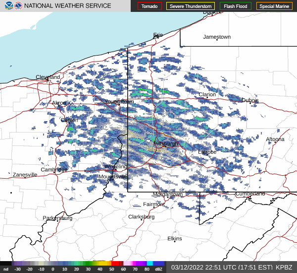
Special Weather Statement for Allegheny County Issued by National Weather Service Pittsburgh, PA 10:20 PM EST Sat, Mar 12, 2022 ...A HEAVY SNOW BAND WILL AFFECT NORTHEASTERN BEAVER...SOUTHERN LAWRENCE...SOUTHERN BUTLER...NORTHEASTERN ALLEGHENY...NORTHWESTERN WESTMORELAND AND SOUTHWESTERN ARMSTRONG COUNTIES... At 1015 PM EST, a snow band was located north of Pittsburgh and mostly stationary; 1-2 inches snowfall could occur within this band. Winds in excess of 30 mph are possible with this snow band. Locations impacted include... Cranberry, New Castle, Vandergrift, Apollo, New Kensington, Lower Burrell, Harrison Township, Ellwood City, Arnold, Tarentum, Natrona Heights, and Meridian. This includes the following highways... Pennsylvania Turnpike between mile markers 1 and 19. Interstate 79 in Pennsylvania between mile markers 81 and 96. Interstate 376 in Pennsylvania near mile marker 14. -
Western PA/Pittsburgh Winter 2021/22 Discussion
meatwad replied to meatwad's topic in Upstate New York/Pennsylvania
Nice band over northern agc and the new ken area. Enjoy this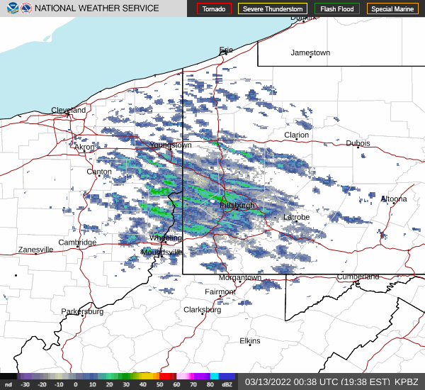
-
Western PA/Pittsburgh Winter 2021/22 Discussion
meatwad replied to meatwad's topic in Upstate New York/Pennsylvania
-
Western PA/Pittsburgh Winter 2021/22 Discussion
meatwad replied to meatwad's topic in Upstate New York/Pennsylvania
Getting nice off and les squalls -
Western PA/Pittsburgh Winter 2021/22 Discussion
meatwad replied to meatwad's topic in Upstate New York/Pennsylvania
8” of snow today, breaks the old record of 6.4” from 1968 and 1.7” yesterday brings storm total to 9.7”. -
Western PA/Pittsburgh Winter 2021/22 Discussion
meatwad replied to meatwad's topic in Upstate New York/Pennsylvania
-
Western PA/Pittsburgh Winter 2021/22 Discussion
meatwad replied to meatwad's topic in Upstate New York/Pennsylvania
still snowing here. -
Western PA/Pittsburgh Winter 2021/22 Discussion
meatwad replied to meatwad's topic in Upstate New York/Pennsylvania
Winter Weather Advisory URGENT - WINTER WEATHER MESSAGE National Weather Service Pittsburgh PA 837 AM EST Sat Mar 12 2022 PAZ008-009-014-015-021-022-029-031-073-075-WVZ002>004-012-021-509- 121700- /O.CON.KPBZ.WW.Y.0010.000000T0000Z-220312T1700Z/ Venango-Forest-Butler-Clarion-Allegheny-Armstrong-Washington- Greene-Westmoreland-Fayette-Brooke-Ohio-Marshall-Wetzel-Marion- Monongalia- Including the cities of Wheeling, Oil City, Ford City, Butler, Kittanning, Monessen, New Kensington, Canonsburg, Latrobe, Uniontown, Waynesburg, Wellsburg, Tionesta, Clarion, Moundsville, Murrysville, Follansbee, Franklin, Washington, Fairmont, Morgantown, New Martinsville, Pittsburgh Metro Area, Lower Burrell, and Greensburg 837 AM EST Sat Mar 12 2022 ...WINTER WEATHER ADVISORY REMAINS IN EFFECT UNTIL NOON EST TODAY... * WHAT...Snow. Additional snow accumulations up to one inch. * WHERE...Portions of northwest, southwest, and western Pennsylvania. Portions of northern and the northern panhandle of West Virginia. * WHEN...Until Noon EST today. * IMPACTS...Plan on slippery road conditions. PRECAUTIONARY/PREPAREDNESS ACTIONS... Slow down and use caution while traveling. The latest road conditions for the state you are calling from can be obtained by calling 5 1 1. && $$ JL
