

meatwad
-
Posts
1,919 -
Joined
-
Last visited
Content Type
Profiles
Blogs
Forums
American Weather
Media Demo
Store
Gallery
Everything posted by meatwad
-

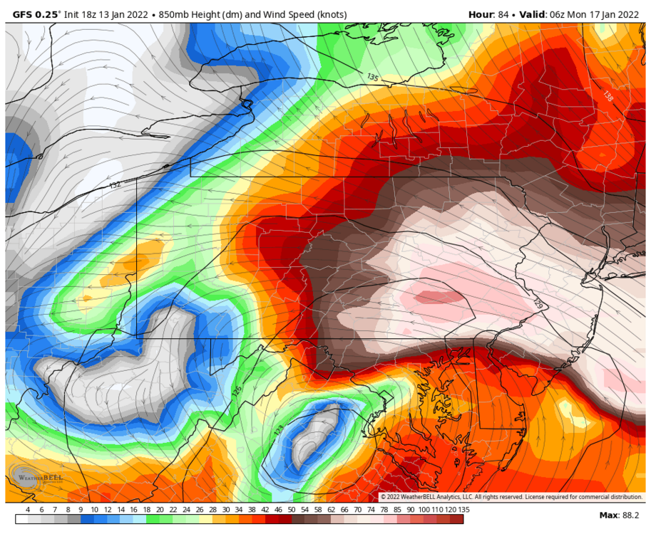
Western PA/Pittsburgh Winter 2021/22 Discussion
meatwad replied to meatwad's topic in Upstate New York/Pennsylvania
-
Western PA/Pittsburgh Winter 2021/22 Discussion
meatwad replied to meatwad's topic in Upstate New York/Pennsylvania
-
Western PA/Pittsburgh Fall Weather Discussion
meatwad replied to Ahoff's topic in Upstate New York/Pennsylvania
new thread here -
Thread for the Winter 2021/22 season.
-
Western PA/Pittsburgh Fall Weather Discussion
meatwad replied to Ahoff's topic in Upstate New York/Pennsylvania
Tornado Warning Tornado Warning PAC003-125-220030- /O.NEW.KPBZ.TO.W.0028.211022T0007Z-211022T0030Z/ BULLETIN - EAS ACTIVATION REQUESTED Tornado Warning National Weather Service Pittsburgh PA 807 PM EDT Thu Oct 21 2021 The National Weather Service in Pittsburgh has issued a * Tornado Warning for... East central Washington County in southwestern Pennsylvania... South central Allegheny County in southwestern Pennsylvania... * Until 830 PM EDT. * At 807 PM EDT, a severe thunderstorm capable of producing a tornado was located over McMurray, moving east at 25 mph. HAZARD...Tornado. SOURCE...Radar indicated rotation. IMPACT...Flying debris will be dangerous to those caught without shelter. Mobile homes will be damaged or destroyed. Damage to roofs, windows, and vehicles will occur. Tree damage is likely. * This dangerous storm will be near... McMurray around 810 PM EDT. Bethel Park and Gastonville around 820 PM EDT. South Park Township, Jefferson Hills and Pleasant Hills around 825 PM EDT. McKeesport, Clairton, Glassport and Liberty around 830 PM EDT. Other locations impacted by this tornadic thunderstorm include Port Vue, Elizabeth, Finleyville, West Elizabeth, Lincoln and Dravosburg. PRECAUTIONARY/PREPAREDNESS ACTIONS... TAKE COVER NOW! Move to a basement or an interior room on the lowest floor of a sturdy building. Avoid windows. If you are outdoors, in a mobile home, or in a vehicle, move to the closest substantial shelter and protect yourself from flying debris. Please report severe weather by calling 412-262-1988, posting to the NWS Pittsburgh Facebook page, or using Twitter @NWSPITTSBURGH. && LAT...LON 4023 8016 4028 8017 4035 7987 4022 7985 TIME...MOT...LOC 0007Z 262DEG 23KT 4026 8012 TORNADO...RADAR INDICATED MAX HAIL SIZE...<.75 IN $$ -
Western PA/Pittsburgh Fall Weather Discussion
meatwad replied to Ahoff's topic in Upstate New York/Pennsylvania
Tornado Warning Tornado Warning PAC003-007-129-220000- /O.NEW.KPBZ.TO.W.0027.211021T2340Z-211022T0000Z/ BULLETIN - EAS ACTIVATION REQUESTED Tornado Warning National Weather Service Pittsburgh PA 740 PM EDT Thu Oct 21 2021 The National Weather Service in Pittsburgh has issued a * Tornado Warning for... East central Beaver County in western Pennsylvania... Northeastern Allegheny County in southwestern Pennsylvania... Northwestern Westmoreland County in southwestern Pennsylvania... * Until 800 PM EDT. * At 740 PM EDT, a severe thunderstorm capable of producing a tornado was located over Franklin Park, moving east at 35 mph. HAZARD...Tornado. SOURCE...Radar indicated rotation. IMPACT...Flying debris will be dangerous to those caught without shelter. Mobile homes will be damaged or destroyed. Damage to roofs, windows, and vehicles will occur. Tree damage is likely. * This dangerous storm will be near... Ross Township, Bellevue, West View and McKees Rocks around 745 PM EDT. Pittsburgh, McCandless Township, Shaler Township and Gibsonia around 750 PM EDT. Millvale, Etna and Sharpsburg around 755 PM EDT. Penn Hills, Plum, Hampton Township, Wilkinsburg, New Kensington, O`hara Township, Oakmont, Fox Chapel, Arnold and Springdale around 800 PM EDT. Other locations impacted by this tornadic thunderstorm include Sewickley Hills, Cheswick, Ben Avon Heights, Sewickley Heights, Reserve Township, Glenfield, Russellton, Haysville, Glen Osborne and Curtisville. PRECAUTIONARY/PREPAREDNESS ACTIONS... TAKE COVER NOW! Move to a basement or an interior room on the lowest floor of a sturdy building. Avoid windows. If you are outdoors, in a mobile home, or in a vehicle, move to the closest substantial shelter and protect yourself from flying debris. Please report severe weather by calling 412-262-1988, posting to the NWS Pittsburgh Facebook page, or using Twitter @NWSPITTSBURGH. && LAT...LON 4049 8017 4062 8016 4065 7973 4044 7977 TIME...MOT...LOC 2340Z 277DEG 29KT 4056 8010 TORNADO...RADAR INDICATED MAX HAIL SIZE...<.75 IN $$ -
Western PA/Pittsburgh Fall Weather Discussion
meatwad replied to Ahoff's topic in Upstate New York/Pennsylvania
SEL0 URGENT - IMMEDIATE BROADCAST REQUESTED Tornado Watch Number 510 NWS Storm Prediction Center Norman OK 220 PM EDT Wed Sep 22 2021 The NWS Storm Prediction Center has issued a * Tornado Watch for portions of Eastern Ohio Western Pennsylvania Northern West Virginia Lake Erie * Effective this Wednesday afternoon and evening from 220 PM until 1000 PM EDT. * Primary threats include... A couple tornadoes possible Scattered damaging wind gusts to 70 mph possible SUMMARY...Thunderstorms will intensify this afternoon along a cold front over eastern Ohio, and track northeastward across the watch area. Locally damaging winds are the main threat with these storms, although tornadoes are possible in the most intense cells. The tornado watch area is approximately along and 55 statute miles east and west of a line from 20 miles west northwest of Erie PA to 30 miles west southwest of Morgantown WV. For a complete depiction of the watch see the associated watch outline update (WOUS64 KWNS WOU0). PRECAUTIONARY/PREPAREDNESS ACTIONS... REMEMBER...A Tornado Watch means conditions are favorable for tornadoes and severe thunderstorms in and close to the watch area. Persons in these areas should be on the lookout for threatening weather conditions and listen for later statements and possible warnings. && AVIATION...Tornadoes and a few severe thunderstorms with hail surface and aloft to 1 inch. Extreme turbulence and surface wind gusts to 60 knots. A few cumulonimbi with maximum tops to 450. Mean storm motion vector 21035. ...Hart -
Western PA/Pittsburgh Summer Discussion 2021
meatwad replied to Ahoff's topic in Upstate New York/Pennsylvania
Flash Flood Warning Flash Flood Warning PAC003-125-252330- /O.NEW.KPBZ.FF.W.0034.210825T2205Z-210825T2330Z/ /00000.0.ER.000000T0000Z.000000T0000Z.000000T0000Z.OO/ BULLETIN - EAS ACTIVATION REQUESTED Flash Flood Warning National Weather Service Pittsburgh PA 605 PM EDT Wed Aug 25 2021 The National Weather Service in Pittsburgh has issued a * Flash Flood Warning for... Central Allegheny County in southwestern Pennsylvania... Central Washington County in southwestern Pennsylvania... * Until 730 PM EDT. * At 605 PM EDT, Doppler radar indicated thunderstorms producing heavy rain across the warned area. Between 1.5 and 3 inches of rain have fallen. Additional rainfall amounts of 1 to 2 inches are possible in the warned area. Flash flooding is ongoing or expected to begin shortly. HAZARD...Flash flooding caused by thunderstorms. SOURCE...Radar. IMPACT...Flash flooding of small creeks and streams, urban areas, highways, streets and underpasses as well as other poor drainage and low-lying areas. * Some locations that will experience flash flooding include... Pittsburgh, Penn Hills, Mount Lebanon, Bethel Park, McMurray, McKeesport, Shaler Township, West Mifflin, North Side Pittsburgh, Baldwin, Upper St. Clair, Scott Township, Wilkinsburg, Whitehall, South Park Township, Robinson Township, Munhall, Jefferson Hills, Brentwood and Swissvale. PRECAUTIONARY/PREPAREDNESS ACTIONS... Turn around, don`t drown when encountering flooded roads. Most flood deaths occur in vehicles. && LAT...LON 4048 8008 4051 7986 4029 7985 4029 8012 FLASH FLOOD...RADAR INDICATED $$ -
Western PA/Pittsburgh Summer Discussion 2021
meatwad replied to Ahoff's topic in Upstate New York/Pennsylvania
Flash Flood Warning Flash Flood Warning PAC003-019-252245- /O.NEW.KPBZ.FF.W.0030.210825T2117Z-210825T2245Z/ /00000.0.ER.000000T0000Z.000000T0000Z.000000T0000Z.OO/ BULLETIN - EAS ACTIVATION REQUESTED Flash Flood Warning National Weather Service Pittsburgh PA 517 PM EDT Wed Aug 25 2021 The National Weather Service in Pittsburgh has issued a * Flash Flood Warning for... North Central Allegheny County in southwestern Pennsylvania... Southwestern Butler County in west central Pennsylvania... * Until 645 PM EDT. * At 517 PM EDT, Doppler radar indicated thunderstorms producing heavy rain across the warned area. Between 1.5 and 2.5 inches of rain have fallen. Additional rainfall amounts of 1 to 2 inches are possible in the warned area. Flash flooding is ongoing or expected to begin shortly. HAZARD...Flash flooding caused by thunderstorms. SOURCE...Radar. IMPACT...Flash flooding of small creeks and streams, urban areas, highways, streets and underpasses as well as other poor drainage and low-lying areas. * Some locations that will experience flash flooding include... McCandless Township, Cranberry, Franklin Park, Hampton Township, Economy, Wexford, Zelienople, Seven Fields, Gibsonia, Oak Hills, Evans City, Mars, Bell Acres, Nixon, Bradfordwoods, Harmony, Valencia, Connoquenessing, Callery and Pine Township. PRECAUTIONARY/PREPAREDNESS ACTIONS... Turn around, don`t drown when encountering flooded roads. Most flood deaths occur in vehicles. Be aware of your surroundings and do not drive on flooded roads. && LAT...LON 4082 8016 4082 7991 4060 7990 4059 8020 4060 8019 4061 8018 4061 8017 4061 8015 FLASH FLOOD...RADAR INDICATED $$ -
Western PA/Pittsburgh Summer Discussion 2021
meatwad replied to Ahoff's topic in Upstate New York/Pennsylvania
Flood Advisory Flood Advisory National Weather Service Pittsburgh PA 925 AM EDT Wed Aug 18 2021 PAC003-007-125-129-181730- /O.NEW.KPBZ.FA.Y.0055.210818T1325Z-210818T1730Z/ /00000.N.ER.000000T0000Z.000000T0000Z.000000T0000Z.OO/ Allegheny PA-Beaver PA-Washington PA-Westmoreland PA- 925 AM EDT Wed Aug 18 2021 The National Weather Service in Pittsburgh has issued a * Urban and Small Stream Flood Advisory for... Allegheny County in southwestern Pennsylvania... Central Washington County in southwestern Pennsylvania... Northwestern Westmoreland County in southwestern Pennsylvania... Southeastern Beaver County in western Pennsylvania... * Until 130 PM EDT. * At 925 AM EDT, Doppler radar indicated heavy rain. This will cause urban and small stream flooding. Between 1 and 1.5 inches of rain have fallen. * Some locations that will experience flooding include... Pittsburgh, Penn Hills, Mount Lebanon, Bethel Park, Ross Township, McCandless Township, Monroeville, Moon Township, McMurray, Greensburg, McKeesport, Franklin Park, Jeannette, Aliquippa, Gastonville, Shaler Township, Plum, West Mifflin, North Side Pittsburgh and Baldwin. Additional rainfall amounts of 1 to 1.5 inches are expected over the area. This additional rain will result in minor flooding. PRECAUTIONARY/PREPAREDNESS ACTIONS... Turn around, don`t drown when encountering flooded roads. Most flood deaths occur in vehicles. Be aware of your surroundings and do not drive on flooded roads. In hilly terrain there are hundreds of low water crossings which are potentially dangerous in heavy rain. Do not attempt to cross flooded roads. Find an alternate route. && LAT...LON 4048 8043 4055 8042 4066 8026 4066 8016 4059 7975 4041 7954 4023 7957 4022 7968 4023 7986 4025 8013 4048 8036 $$ -
Western PA/Pittsburgh Summer Discussion 2021
meatwad replied to Ahoff's topic in Upstate New York/Pennsylvania
Flash Flood Watch Flood Watch National Weather Service Pittsburgh PA 128 PM EDT Tue Aug 17 2021 OHZ049-050-058-059-068-069-PAZ008-009-014>016-020>023-029-031- 073>076-WVZ001>004-012-021-509>514-180300- /O.NEW.KPBZ.FF.A.0004.210818T0900Z-210819T0000Z/ /00000.0.ER.000000T0000Z.000000T0000Z.000000T0000Z.OO/ Harrison-Jefferson OH-Guernsey-Belmont-Noble-Monroe-Venango- Forest-Butler-Clarion-Jefferson PA-Beaver-Allegheny-Armstrong- Indiana-Washington-Greene-Westmoreland-Higher Elevations of Westmoreland-Fayette-Higher Elevations of Fayette-Hancock-Brooke- Ohio-Marshall-Wetzel-Marion-Monongalia-Ridges of Eastern Monongalia and Northwestern Preston-Preston-Eastern Preston- Western Tucker-Eastern Tucker- Including the cities of Canonsburg, Thomas, New Kensington, Punxsutawney, Caldwell, Pittsburgh Metro Area, New Martinsville, Greensburg, Hendricks, Steubenville, Ligonier, Beaver Falls, Butler, Indiana, Aliquippa, Rowlesburg, Terra Alta, Champion, Coopers Rock, Hazelton, Murrysville, Weirton, St. Clairsville, Tionesta, Kittanning, Woodsfield, Moundsville, Ford City, Morgantown, Ohiopyle, Ambridge, Kingwood, Cadiz, Oil City, Clarion, Uniontown, Latrobe, Monessen, Franklin, Canaan Valley, Davis, Monaca, Wheeling, Wellsburg, Parsons, Lower Burrell, Cambridge, Saint George, Donegal, Washington, Waynesburg, Fairmont, Martins Ferry, Bruceton Mills, Brookville, and Follansbee 128 PM EDT Tue Aug 17 2021 ...FLASH FLOOD WATCH IN EFFECT FROM LATE TONIGHT THROUGH WEDNESDAY EVENING... The National Weather Service in Pittsburgh has issued a * Flash Flood Watch for Portions of east central Ohio, including the following areas, Belmont, Guernsey, Harrison, Jefferson OH, Monroe and Noble. Portions of Pennsylvania, including the following areas, Allegheny, Armstrong, Beaver, Butler, Clarion, Fayette, Forest, Greene, Higher Elevations of Fayette, Higher Elevations of Westmoreland, Indiana, Jefferson PA, Venango, Washington and Westmoreland. Portions of West Virginia, including the following areas, Brooke, Eastern Preston, Eastern Tucker, Hancock, Marion, Marshall, Monongalia, Ohio, Preston, Ridges of Eastern Monongalia and Northwestern Preston, Western Tucker and Wetzel. * From late tonight through Wednesday evening. * Showers and isolated thunderstorms are expected Wednesday as the remnants of Tropical Storm Fred move through the region. Heavy rain on increasingly saturated grounds will increased the threat for flash flooding. Rainfall amounts between 1.5 to 2.5 inches will be possible with potential for locally higher amounts. PRECAUTIONARY/PREPAREDNESS ACTIONS... You should monitor later forecasts and be prepared to take action should Flash Flood Warnings be issued. && -
Western PA/Pittsburgh Summer Discussion 2021
meatwad replied to Ahoff's topic in Upstate New York/Pennsylvania
Flash Flood Warning for Allegheny County Issued by National Weather Service Pittsburgh, PA 7:45 PM EDT Fri, Aug 13, 2021 The National Weather Service in Pittsburgh has issued a * Flash Flood Warning for... Central Allegheny County in southwestern Pennsylvania... * Until 1045 PM EDT. * At 745 PM EDT, Doppler radar indicated thunderstorms producing heavy rain across the warned area. Around an inch of rain has fallen in short duration. Flash flooding is ongoing or expected to begin shortly. HAZARD...Flash flooding caused by thunderstorms. SOURCE...Radar. IMPACT...Flash flooding of small creeks and streams, urban areas, highways, streets and underpasses as well as other poor drainage and low-lying areas. * Some locations that will experience flash flooding include... Pittsburgh, Penn Hills, Ross Township, Franklin Park, Shaler Township, Plum, North Side Pittsburgh, Hampton Township, Scott Township, Wilkinsburg, Robinson Township, O'hara Township, Bellevue, Carnegie, Kennedy Township, West View, Stowe Township, Oakmont, McKees Rocks and Crafton. PRECAUTIONARY/PREPAREDNESS ACTIONS... Turn around, don't drown when encountering flooded roads. Most flood deaths occur in vehicles. In hilly terrain there are hundreds of low water crossings which are potentially dangerous in heavy rain. Do not attempt to cross flooded roads. Find an alternate route. && FLASH FLOOD...RADAR INDICATED -
Western PA/Pittsburgh Summer Discussion 2021
meatwad replied to Ahoff's topic in Upstate New York/Pennsylvania
Severe Thunderstorm Warning for Allegheny County Issued by National Weather Service Pittsburgh, PA 7:21 PM EDT Fri, Aug 13, 2021 The National Weather Service in Pittsburgh has issued a * Severe Thunderstorm Warning for... Central Allegheny County in southwestern Pennsylvania... * Until 800 PM EDT. * At 720 PM EDT, a severe thunderstorm was located over Stowe Township, or near Ross Township, moving east at 30 mph. HAZARD...60 mph wind gusts. SOURCE...Radar indicated. IMPACT...Expect damage to trees and power lines, resulting in some power outages. * Locations impacted include... Pittsburgh, Penn Hills, Ross Township, McCandless Township, Monroeville, Franklin Park, Shaler Township, Plum, West Mifflin, North Side Pittsburgh, Baldwin, and Hampton Township. PRECAUTIONARY/PREPAREDNESS ACTIONS... For your protection move to an interior room on the lowest floor of a building. Please report severe weather by calling 412-262-1988, posting to the NWS Pittsburgh Facebook page, or using Twitter @NWSPITTSBURGH. && HAIL THREAT...RADAR INDICATED; MAX HAIL SIZE...<.75 IN; WIND THREAT...RADAR INDICATED; MAX WIND GUST...60 MPH -
Western PA/Pittsburgh Summer Discussion 2021
meatwad replied to Ahoff's topic in Upstate New York/Pennsylvania
Severe Thunderstorm Warning for Allegheny County Issued by National Weather Service Pittsburgh, PA 7:02 PM EDT Fri, Aug 13, 2021 The National Weather Service in Pittsburgh has issued a * Severe Thunderstorm Warning for... East central Washington County in southwestern Pennsylvania... Southeastern Allegheny County in southwestern Pennsylvania... Southwestern Westmoreland County in southwestern Pennsylvania... Northeastern Fayette County in southwestern Pennsylvania... * Until 730 PM EDT. * At 702 PM EDT, severe thunderstorms were located along a line extending from Donora to near South Connellsville, moving east at 25 mph. HAZARD...60 mph wind gusts. SOURCE...Radar indicated. IMPACT...Damage to trees and power lines. * Locations impacted include... Greensburg, Jeannette, Connellsville, Monessen, California, Donora, Mount Pleasant, Scottdale, Charleroi, Youngwood, West Newton, and New Stanton. PRECAUTIONARY/PREPAREDNESS ACTIONS... For your protection move to an interior room on the lowest floor of a building. Please report severe weather by calling 412-262-1988, posting to the NWS Pittsburgh Facebook page, or using Twitter @NWSPITTSBURGH. && -
Western PA/Pittsburgh Summer Discussion 2021
meatwad replied to Ahoff's topic in Upstate New York/Pennsylvania
Flood Warning Flood Warning National Weather Service Pittsburgh PA 1032 PM EDT Thu Aug 12 2021 PAC003-125-129-130545- /O.NEW.KPBZ.FA.W.0006.210813T0232Z-210813T0545Z/ /00000.0.ER.000000T0000Z.000000T0000Z.000000T0000Z.OO/ Allegheny PA-Washington PA-Westmoreland PA- 1032 PM EDT Thu Aug 12 2021 The National Weather Service in Pittsburgh has issued a * Flood Warning for Urban area and small stream in... Southeastern Allegheny County in southwestern Pennsylvania... Central Washington County in southwestern Pennsylvania... Northwestern Westmoreland County in southwestern Pennsylvania... * Until 145 AM EDT. * At 1032 PM EDT, Doppler radar indicated heavy rain due to thunderstorms. Flooding is already occurring in the warned area. Between 2 and 3 inches of rain have fallen. * Some locations that will experience flooding include... Pittsburgh, Penn Hills, Mount Lebanon, Bethel Park, Ross Township, Monroeville, McMurray, Greensburg, McKeesport, Jeannette, Canonsburg, Gastonville, Shaler Township, Plum, West Mifflin, North Side Pittsburgh, Baldwin, Upper St. Clair, Murrysville and Scott Township. PRECAUTIONARY/PREPAREDNESS ACTIONS... Turn around, don`t drown when encountering flooded roads. Most flood deaths occur in vehicles. Be especially cautious at night when it is harder to recognize the dangers of flooding. && LAT...LON 4065 7970 4037 7943 4014 7995 4033 8035 $$ -
Western PA/Pittsburgh Summer Discussion 2021
meatwad replied to Ahoff's topic in Upstate New York/Pennsylvania
Flash Flood Warning Flash Flood Statement National Weather Service Pittsburgh PA 920 PM EDT Thu Aug 12 2021 OHC081-PAC003-005-007-019-125-129-WVC009-029-130345- /O.CON.KPBZ.FF.W.0024.000000T0000Z-210813T0345Z/ /00000.0.ER.000000T0000Z.000000T0000Z.000000T0000Z.OO/ Jefferson OH OH-Allegheny PA-Armstrong PA-Beaver PA-Butler PA- Washington PA-Westmoreland PA-Brooke WV-Hancock WV- 920 PM EDT Thu Aug 12 2021 ...FLASH FLOOD WARNING REMAINS IN EFFECT UNTIL 1145 PM EDT THIS EVENING FOR SOUTHEASTERN JEFFERSON OH, NORTHERN ALLEGHENY, NORTHWESTERN WASHINGTON, WESTERN WESTMORELAND, SOUTHWESTERN ARMSTRONG, SOUTHEASTERN BUTLER, SOUTHERN BEAVER, BROOKE AND HANCOCK COUNTIES... At 920 PM EDT, Radar indicated thunderstorms producing heavy rain across the warned area. Between 2 and 3 inches of rain have fallen, with an additional 1 to 2 inches expected. Flash flooding is ongoing or expected to begin shortly. HAZARD...Flash flooding caused by thunderstorms. SOURCE...Radar. IMPACT...Flash flooding of small creeks and streams, urban areas, highways, streets and underpasses as well as other poor drainage and low-lying areas. Some locations that will experience flash flooding include... Pittsburgh, Ross Township, McCandless Township, Cranberry, Moon Township, Weirton, Steubenville, Franklin Park, Aliquippa, Wellsburg, Avella, Shaler Township, Hampton Township, Robinson Township, Harrison Township, Economy, O`hara Township, Bellevue, Kennedy Township and Ambridge. PRECAUTIONARY/PREPAREDNESS ACTIONS... Turn around, don`t drown when encountering flooded roads. Most flood deaths occur in vehicles. Be especially cautious at night when it is harder to recognize the dangers of flooding. && LAT...LON 4027 8079 4039 8069 4048 8052 4068 8015 4068 7969 4066 7970 4064 7970 4064 7969 4032 8036 4025 8052 4019 8066 FLASH FLOOD...RADAR INDICATED $$ -
Western PA/Pittsburgh Summer Discussion 2021
meatwad replied to Ahoff's topic in Upstate New York/Pennsylvania
Severe Thunderstorm Warning for Allegheny County Issued by National Weather Service Pittsburgh, PA 8:39 PM EDT Thu, Aug 12, 2021 The National Weather Service in Pittsburgh has issued a * Severe Thunderstorm Warning for... Southeastern Jefferson County in east central Ohio... Southwestern Beaver County in western Pennsylvania... Northwestern Washington County in southwestern Pennsylvania... West central Allegheny County in southwestern Pennsylvania... Ohio County in northern West Virginia... Brooke County in northern West Virginia... Hancock County in northern West Virginia... * Until 930 PM EDT. * At 839 PM EDT, a severe thunderstorm was located near Wellsburg, moving northeast at 30 mph. HAZARD...60 mph wind gusts. SOURCE...Radar indicated. IMPACT...Expect damage to trees and power lines, resulting in some power outages. * Locations impacted include... Weirton, Steubenville, Wellsburg, West Liberty, Avella, Robinson Township, Toronto, Wintersville, Mingo Junction, Follansbee, Midland, and Hooverson Heights. PRECAUTIONARY/PREPAREDNESS ACTIONS... For your protection move to an interior room on the lowest floor of a building. Torrential rainfall is occurring with this storm, and may lead to flash flooding. Do not drive your vehicle through flooded roadways. Please report severe weather by calling 412-262-1988, posting to the NWS Pittsburgh Facebook page, or using Twitter @NWSPITTSBURGH. && HAIL THREAT...RADAR INDICATED; MAX HAIL SIZE...<.75 IN; WIND THREAT...RADAR INDICATED; MAX WIND GUST...60 MPH -
Western PA/Pittsburgh Summer Discussion 2021
meatwad replied to Ahoff's topic in Upstate New York/Pennsylvania
Imagine this training thunderstorm was training thunder snow. -
Western PA/Pittsburgh Summer Discussion 2021
meatwad replied to Ahoff's topic in Upstate New York/Pennsylvania
Flash Flood Warning Flash Flood Statement National Weather Service Pittsburgh PA 819 PM EDT Thu Aug 12 2021 PAC003-125-129-130230- /O.CON.KPBZ.FF.W.0023.000000T0000Z-210813T0230Z/ /00000.0.ER.000000T0000Z.000000T0000Z.000000T0000Z.OO/ Allegheny PA-Washington PA-Westmoreland PA- 819 PM EDT Thu Aug 12 2021 ...FLASH FLOOD WARNING REMAINS IN EFFECT UNTIL 1030 PM EDT THIS EVENING FOR SOUTHEASTERN ALLEGHENY, CENTRAL WASHINGTON AND NORTHWESTERN WESTMORELAND COUNTIES... At 819 PM EDT, Radar indicated thunderstorms producing heavy rain across the warned area. Between 1 and 2 inches of rain have fallen, with an additional 1 to 1.50 inches expected. Flash flooding is ongoing or expected to begin shortly. HAZARD...Flash flooding caused by thunderstorms. SOURCE...Radar. IMPACT...Flash flooding of small creeks and streams, urban areas, highways, streets and underpasses as well as other poor drainage and low-lying areas. Some locations that will experience flash flooding include... Pittsburgh, Penn Hills, Mount Lebanon, Bethel Park, Ross Township, Monroeville, McMurray, Greensburg, McKeesport, Jeannette, Canonsburg, Gastonville, Shaler Township, Plum, West Mifflin, North Side Pittsburgh, Baldwin, Upper St. Clair, Murrysville and Scott Township. PRECAUTIONARY/PREPAREDNESS ACTIONS... Be especially cautious at night when it is harder to recognize the dangers of flooding. && LAT...LON 4033 8035 4065 7970 4064 7969 4037 7943 4017 7989 4014 7995 FLASH FLOOD...RADAR INDICATED $$ -
Western PA/Pittsburgh Summer Discussion 2021
meatwad replied to Ahoff's topic in Upstate New York/Pennsylvania
Severe Thunderstorm Warning for Allegheny County Issued by National Weather Service Pittsburgh, PA 8:02 PM EDT Thu, Aug 12, 2021 ...A SEVERE THUNDERSTORM WARNING REMAINS IN EFFECT UNTIL 830 PM EDT FOR NORTHWESTERN WASHINGTON AND NORTHERN ALLEGHENY COUNTIES... At 801 PM EDT, a severe thunderstorm was located over Sturgeon-Noblestown, or near Moon Township, moving east at 40 mph. HAZARD...60 mph wind gusts. SOURCE...Radar indicated. IMPACT...Expect damage to trees and power lines, resulting in some power outages. Locations impacted include... Pittsburgh, Penn Hills, Ross Township, McCandless Township, Moon Township, Franklin Park, Shaler Township, Plum, North Side Pittsburgh, Hampton Township, Scott Township, and Robinson Township. PRECAUTIONARY/PREPAREDNESS ACTIONS... Torrential rainfall is occurring with this storm, and may lead to flash flooding. Do not drive your vehicle through flooded roadways. Please report severe weather by calling 412-262-1988, posting to the NWS Pittsburgh Facebook page, or using Twitter @NWSPITTSBURGH. && HAIL THREAT...RADAR INDICATED; MAX HAIL SIZE...<.75 IN; WIND THREAT...RADAR INDICATED; MAX WIND GUST...60 MPH -
Western PA/Pittsburgh Summer Discussion 2021
meatwad replied to Ahoff's topic in Upstate New York/Pennsylvania
Flash Flood Warning for Allegheny County Issued by National Weather Service Pittsburgh, PA 7:31 PM EDT Thu, Aug 12, 2021 The National Weather Service in Pittsburgh has issued a * Flash Flood Warning for... Southeastern Allegheny County in southwestern Pennsylvania... Central Washington County in southwestern Pennsylvania... Northwestern Westmoreland County in southwestern Pennsylvania... * Until 1030 PM EDT. * At 731 PM EDT, Radar indicated thunderstorms producing heavy rain across the warned area. Between 0.5 and 1 inch of rain has fallen, with additional 1.0 to 2.0 inches expected. Flash flooding is ongoing or expected to begin shortly. HAZARD...Flash flooding caused by thunderstorms. SOURCE...Radar. IMPACT...Flash flooding of small creeks and streams, urban areas, highways, streets and underpasses as well as other poor drainage and low-lying areas. * Some locations that will experience flash flooding include... Pittsburgh, Penn Hills, Mount Lebanon, Bethel Park, Ross Township, Monroeville, McMurray, Greensburg, McKeesport, Jeannette, Canonsburg, Gastonville, Shaler Township, Plum, West Mifflin, North Side Pittsburgh, Baldwin, Upper St. Clair, Murrysville and Scott Township. PRECAUTIONARY/PREPAREDNESS ACTIONS... Turn around, don't drown when encountering flooded roads. Most flood deaths occur in vehicles. && FLASH FLOOD...RADAR INDICATED -
Western PA/Pittsburgh Summer Discussion 2021
meatwad replied to Ahoff's topic in Upstate New York/Pennsylvania
Severe Thunderstorm Warning for Allegheny County Issued by National Weather Service Pittsburgh, PA 7:01 PM EDT Thu, Aug 12, 2021 ...A SEVERE THUNDERSTORM WARNING REMAINS IN EFFECT UNTIL 715 PM EDT FOR CENTRAL WASHINGTON...ALLEGHENY AND BROOKE COUNTIES... At 701 PM EDT, severe thunderstorms were located along a line extending from New Kensington to Castle Shannon to near West Liberty, moving east at 30 mph. HAZARD...60 mph wind gusts. SOURCE...Radar indicated. IMPACT...Expect damage to trees and power lines, resulting in some power outages. Locations impacted include... Pittsburgh, Penn Hills, Mount Lebanon, Bethel Park, Ross Township, McCandless Township, Monroeville, Moon Township, McMurray, McKeesport, Washington, and Franklin Park. PRECAUTIONARY/PREPAREDNESS ACTIONS... For your protection move to an interior room on the lowest floor of a building. Please report severe weather by calling 412-262-1988, posting to the NWS Pittsburgh Facebook page, or using Twitter @NWSPITTSBURGH. && HAIL THREAT...RADAR INDICATED; MAX HAIL SIZE...<.75 IN; WIND THREAT...RADAR INDICATED; MAX WIND GUST...60 MPH -
Western PA/Pittsburgh Summer Discussion 2021
meatwad replied to Ahoff's topic in Upstate New York/Pennsylvania
SEL3 URGENT - IMMEDIATE BROADCAST REQUESTED Severe Thunderstorm Watch Number 433 NWS Storm Prediction Center Norman OK 345 PM EDT Thu Aug 12 2021 The NWS Storm Prediction Center has issued a * Severe Thunderstorm Watch for portions of Northeastern Ohio Western Pennsylvania The northern West Virginia Panhandle Lake Erie * Effective this Thursday afternoon and evening from 345 PM until 1000 PM EDT. * Primary threats include... Scattered damaging wind gusts to 70 mph likely Isolated large hail events to 1 inch in diameter possible SUMMARY...Thunderstorms are beginning to form in northeastern Ohio, and storm coverage/intensity is expected to increase through the remainder of the afternoon as storms move into western Pennsylvania. The storm environment favors clusters of storms with damaging winds of 60-70 mph, and the strongest storms may also produce isolated large hail near 1 inch diameter. The severe thunderstorm watch area is approximately along and 55 statute miles north and south of a line from 20 miles south southwest of Cleveland OH to 35 miles north northeast of Latrobe PA. For a complete depiction of the watch see the associated watch outline update (WOUS64 KWNS WOU3). PRECAUTIONARY/PREPAREDNESS ACTIONS... REMEMBER...A Severe Thunderstorm Watch means conditions are favorable for severe thunderstorms in and close to the watch area. Persons in these areas should be on the lookout for threatening weather conditions and listen for later statements and possible warnings. Severe thunderstorms can and occasionally do produce tornadoes. && OTHER WATCH INFORMATION...CONTINUE...WW 431...WW 432... AVIATION...A few severe thunderstorms with hail surface and aloft to 1 inch. Extreme turbulence and surface wind gusts to 60 knots. A few cumulonimbi with maximum tops to 550. Mean storm motion vector 28035. ...Thompson -
Western PA/Pittsburgh Summer Discussion 2021
meatwad replied to Ahoff's topic in Upstate New York/Pennsylvania
Thunderstorm Warning Severe Weather Statement National Weather Service Pittsburgh PA 1241 PM EDT Thu Aug 12 2021 PAC003-007-019-129-121715- /O.CON.KPBZ.SV.W.0241.000000T0000Z-210812T1715Z/ Beaver PA-Butler PA-Allegheny PA-Westmoreland PA- 1241 PM EDT Thu Aug 12 2021 ...A SEVERE THUNDERSTORM WARNING REMAINS IN EFFECT UNTIL 115 PM EDT FOR SOUTHEASTERN BEAVER...SOUTHWESTERN BUTLER...NORTHERN ALLEGHENY AND NORTHWESTERN WESTMORELAND COUNTIES... At 1241 PM EDT, a severe thunderstorm was located over Emsworth, or near Franklin Park, moving southeast at 40 mph. HAZARD...60 mph wind gusts. SOURCE...Radar indicated. IMPACT...Expect damage to trees and power lines, resulting in some power outages. Locations impacted include... Pittsburgh, Penn Hills, Mount Lebanon, Ross Township, McCandless Township, Cranberry, Moon Township, Franklin Park, Aliquippa, Monaca, Shaler Township, and Plum. PRECAUTIONARY/PREPAREDNESS ACTIONS... For your protection move to an interior room on the lowest floor of a building. Please report severe weather by calling 412-262-1988, posting to the NWS Pittsburgh Facebook page, or using Twitter @NWSPITTSBURGH. && LAT...LON 4058 7970 4042 7990 4038 8003 4062 8035 4077 8020 TIME...MOT...LOC 1641Z 296DEG 33KT 4053 8012 HAIL THREAT...RADAR INDICATED MAX HAIL SIZE...<.75 IN WIND THREAT...RADAR INDICATED MAX WIND GUST...60 MPH $$ -
Western PA/Pittsburgh Summer Discussion 2021
meatwad replied to Ahoff's topic in Upstate New York/Pennsylvania
Severe Thunderstorm Warning Severe Thunderstorm Warning PAC003-007-125-141900- /O.NEW.KPBZ.SV.W.0033.210614T1833Z-210614T1900Z/ BULLETIN - IMMEDIATE BROADCAST REQUESTED Severe Thunderstorm Warning National Weather Service Pittsburgh PA 233 PM EDT Mon Jun 14 2021 The National Weather Service in Pittsburgh has issued a * Severe Thunderstorm Warning for... South central Beaver County in western Pennsylvania... North central Washington County in southwestern Pennsylvania... West central Allegheny County in southwestern Pennsylvania... * Until 300 PM EDT. * At 233 PM EDT, a severe thunderstorm was located near Imperial, or near Moon Township, moving southeast at 40 mph. HAZARD...Wind gusts to 60 mph. SOURCE...Radar. IMPACT...Expect damage to trees and power lines, resulting in some power outages. * Locations impacted include... Pittsburgh... Mount Lebanon... Bethel Park... Moon Township... Upper St. Clair... Scott Township... Whitehall... Robinson Township... Cecil-Bishop... Dormont... Bellevue... Castle Shannon... This includes the following highways... Interstate 79 in Pennsylvania between mile markers 50 and 66. Interstate 376 in Pennsylvania between mile markers 48 and 68. PRECAUTIONARY/PREPAREDNESS ACTIONS... Move to an interior room on the lowest floor of a building. Please report severe weather by calling 412-262-1988, posting to the NWS Pittsburgh Facebook page, or using Twitter @NWSPITTSBURGH. && LAT...LON 4047 8050 4060 8038 4049 8005 4036 8001 4029 8022 TIME...MOT...LOC 1833Z 294DEG 35KT 4049 8033 HAIL...<.75IN WIND...60MPH $$

