Shack
-
Posts
284 -
Joined
-
Last visited
Content Type
Profiles
Blogs
Forums
American Weather
Media Demo
Store
Gallery
Everything posted by Shack
-
Tornado Warning for west central Georgia: The National Weather Service in Peachtree City has issued a * Tornado Warning for... Northeastern Muscogee County in west central Georgia... Southwestern Talbot County in west central Georgia... Southeastern Harris County in west central Georgia... * Until 445 PM EDT. * At 357 PM EDT, a severe thunderstorm capable of producing a tornado was located over Midland, or 10 miles northeast of Columbus, moving northeast at 40 mph. HAZARD...Tornado. SOURCE...Radar indicated rotation. IMPACT...Flying debris will be dangerous to those caught without shelter. Mobile homes will be damaged or destroyed. Damage to roofs, windows, and vehicles will occur. Tree damage is likely. * Locations impacted include... Ellerslie, Flat Rock, Junction City, Midland, Baldwinville, Baughville, Upatoi, Olive Branch, Talbotton, Po Biddy Crossroads, Geneva, and Waverly Hall.
-
NWS dropped NWS dropped the tornado warning for that one. Dogs don't care. Still piled around my feet.
-
First flash of lighting here was at 1:58am. I had my clock set to get up at 2:00 to do storm-watch duty for the household. Go figure. 70/62 Watching that booger that just crossed the Alabama/GA line track pretty dang much in a straight line to MCN. Pretty good hail sig in that line tracking through Talbot and Upson county. Dogs piled around my feet.
-
Euro, says....no. (for now)
-
GFS says yes, .....
-
Reporting from St. Louis. 34deg and ..... I'm one mile from KSUS, Spirit of St. Louis airport in Chesterfield at my daughter's house. For the first time in my life, THUNDERSLEET ! Walked the dog outside as it was very lightly sprinkling rain, could see lightning and hearing occasional thunder and then "Bam!" and the lightning shook the ground. I was startled but, almost like it shook the sleet from the clouds, the sound of "shlllllleeeeettt" hitting the ground like it had been dropped from a bomb bay stopped me in my tracks. Only lasted for about 20 seconds but, wow. Too cool. And, yes, the dog was more than ready to go back inside, looking at me like, "What the heck are you looking at and smiling ??!!"
-
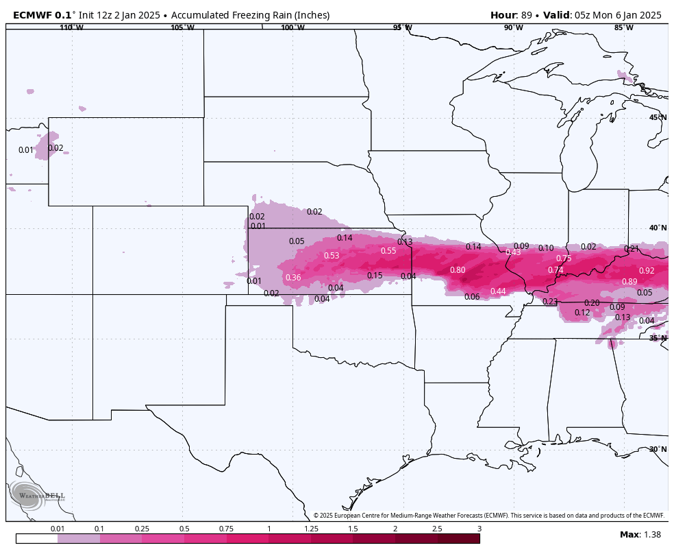
Many thanks for the stat's that you provided in the long range thread leading up to this. It's been a great few past days to speculate and then watch it all play out. Topped out at 2.1" here.
-
If you want some fun later this week, just go back to the long range thread, page 40 or so, I think, and start reading the beginning comments on what has become The Brick Storm.
-
Glad to hear you escaped ! I have good friends from Peach County. I was around for Feb '73. Thomaston area, then. Second grade, too. Got almost two feet ! Still steady light snow but only about an inch here, thus far. Hoping that those heavier returns in Alabama make it here. (And Frank Malloy has obviously been drinking the same water as Dick Clark, Tom Cruise, etc)
-
I would call it moderate snow here in Lizella(Macon). Started promptly at 2:00. Cars nicely covered. Yard about 50% covered. 30/21
-
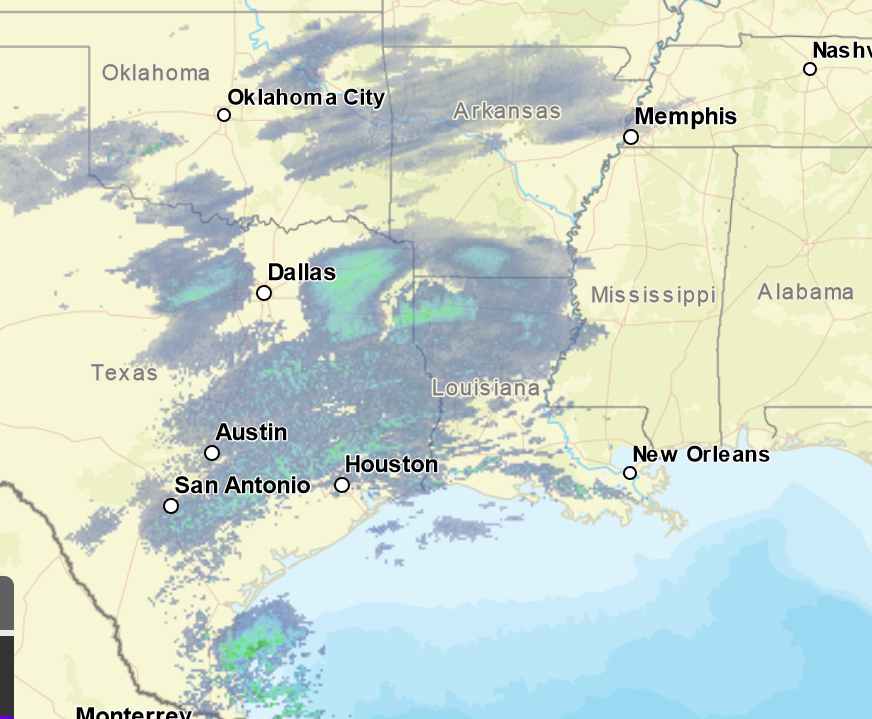
Good to hear. Was really curious about the Arkansas/ North Louisiana returns. I was hoping that moisture transport was more north and maybe a little stronger than modeled.
-
Widespread, but light, Virga Snow (I'm supposing) to our west on radar right now. I looked around and don't see any reporting stations reporting that this is making it to the ground, but this radar image wasn't progged on any of the Hi-res models for this time period, was it? Or, can someone chime in that knows if the models account for virga in their renderings.
-
-
Metal Man and GaWx still looking good.
-
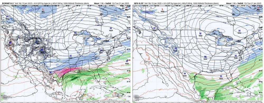
Euro looks wetter than GFS and NAM at 81hrs to me...
-
"One of these things is not like the other ! "
-
1/10-11 super awesome winter SE OBS thread
Shack replied to strongwxnc's topic in Southeastern States
35deg and Light to moderate sleet now. Love the sound of it hitting the super-dry leaves in the yard. -
1/10-11 super awesome winter SE OBS thread
Shack replied to strongwxnc's topic in Southeastern States
Great band that is delivering for the south metro, Tony ! 35/29 here and approximately 13 sleet pellets on the porch. (edit,..14 sleet pellets) -
You must immediately desist with your questioning of the sleet due to Tony and me ! This is science, after all. (sarc)
-
18Z Euro. Oh, boy, I get 0.2" here in Macon !
-
A Burgersighting !! Oh, it's on now.
-
To my eye, the 18z Euro coming in much less amped than the GFS in the gulf. Looks like it might not want to merge that Great Lakes Low like the GFS if it continued past 144hrs, too. HP in Mid Atlantic is a few ticks higher as well.
-
Hey, Tony. Saw you lurking. (off topic for forum, but couldn't send PM) My daughter lives in St. Louis. I've been giving her updates on tomorrow's system for a week and she is now preparing for a Mega-Sleetfest. Man, that's a lot of little frozen balls that are gonna fall in her neighborhood. (cue the jokes) Almost 3" if you believe the HRRR Back on topic: Ugh. At the operationals. Anyone have a DGEX to spark joy?
-
12z Euro. ouch.

-
I-70 Special through Missouri. Totals up with this run. Cut these in half(which we usually need to)and it's still a nice one.