

Baroclinic Zone
-
Posts
46,024 -
Joined
-
Last visited
Content Type
Profiles
Blogs
Forums
American Weather
Media Demo
Store
Gallery
Everything posted by Baroclinic Zone
-

Forecast/storm discussions and part II Manitoba Mauler
Baroclinic Zone replied to Damage In Tolland's topic in New England
Scooter is feeling it. What an odd map to wake up and see from you local friendly CWA. LOL. Good thing they fixed it. -
Forecast/storm discussions and part II Manitoba Mauler
Baroclinic Zone replied to Damage In Tolland's topic in New England
Crushed! See y'all in a few hrs. -
Forecast/storm discussions and part II Manitoba Mauler
Baroclinic Zone replied to Damage In Tolland's topic in New England
. -
Forecast/storm discussions and part II Manitoba Mauler
Baroclinic Zone replied to Damage In Tolland's topic in New England
. This x10000000. I only know bits and pieces of what's going on and if they only knew what's been going on over the last 24-30hrs behind the scenes. -
-

From the album: First snow
-
-
-
 LMAO!!!
 -
166986 10150527997374893 200632219892 8587857 1767364303 N
Baroclinic Zone commented on Isopycnic's gallery image in Members Albums Category
 holy hell
 -
From the album: First snow
-
After that accident he'll be Robo Miser
-
Love it.
-
December 13th, 2007 rakeage. 12" snowstorm.
-
Remembering Snowpocalypse -- 12/18-12/19, 2009
Baroclinic Zone replied to Ian's topic in Mid Atlantic
This storm did not suck imby. I think I ended up with 19". -
Well historically, he did. 14" and done. This was the storm that broke that camels back.
-
11
-
Weenie radar image from January 12, 2011 @ 3am.
-
Devastating tornado strikes Joplin, Missouri
Baroclinic Zone replied to Hoosier's topic in Weather Forecasting and Discussion
JoMo, I wish you, your family, and your community all my thoughts and prayers. You've been through hell and back. -
Devastating tornado strikes Joplin, Missouri
Baroclinic Zone replied to Hoosier's topic in Weather Forecasting and Discussion
I'm just getting up to speed on this. Just devastating news. -
Your posts are all jacked up. This stuff pops up in almost every quoted reply you do. <br /><br /><br /><br /><br /><br /><br /><br /><br /><br /><br /><br /><br /><br /><br /><br /><br /><br /> Makes your posts difficult to read.
-
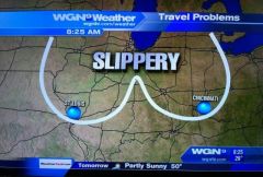
Kevin must have drawn up that map.
-
Weenie Ridge FTW
-
That's why I said impressive overall. Seems like the majority of the area saw 12-36"
-
Not that I recall. TAN recorded 2.07" at the ASOS for L/E. It was a 2 footer storm for me living in downtown Middleborough. Very impressive widespread system.
-
December 5-7 2003