

Baroclinic Zone
-
Posts
47,701 -
Joined
-
Last visited
Content Type
Profiles
Blogs
Forums
American Weather
Media Demo
Store
Gallery
Everything posted by Baroclinic Zone
-

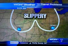
March 12/13/14 Blizzard/Winter Storm/WWA etc
Baroclinic Zone replied to Bostonseminole's topic in New England
000 FXUS61 KBOX 130807 AFDBOX Area Forecast Discussion National Weather Service Taunton MA 407 AM EDT Tue Mar 13 2018 .SYNOPSIS... Low pressure off the Carolina coast rapidly deepening into a coastal storm, affecting southern New England tonight into Tuesday night. This storm will deliver significant accumulating snow, strong to damaging winds, coastal and marine impacts. Blustery and chilly weather continues Thursday and Friday followed by moderating temperatures this weekend. Dry weather probably dominates late in the week through next weekend. && .NEAR TERM /UNTIL 6 PM THIS EVENING/... * Highlights... - Moderate to heavy snow, some locations seeing upwards of a foot to perhaps two feet total accumulation - 1-3"/hr snowfall rates at times, producing visibility less than a quarter of a mile. Winds expected to yield blizzard conditions to the east coastal shoreline of MA. - Strong to damaging winds, E gusts up around 65 mph possible for far E/SE MA coast, brunt of the winds around Tuesday morning into early afternoon - Impacting the Tuesday AM commute with difficult, near impossible travel - Especially the Tuesday morning high tide, strong E onshore flow yielding around a 2 to 3+ foot surge, minor to moderate coastal flooding issues, especially ocean-facing shores, vulnerable areas impacted by earlier storm systems */ Discussion... Precipitation intensity is a critical piece determining precipitation type early this morning. Initial precipitation type early this evening was light rain. As precipitation intensity increased, seeing a rapid switch to snow across the interior. Still some rain towards nantucket early this morning. Overall, the ongoing forecast remains on track. Mainly minor tweaks to snowfall forecast. The other change was to expand the Blizzard Warning along the east coast of Massachusetts. It`s possible, further expansion could occur later this morning. Just don`t have enough confidence in the persistence requirement away from the immediate coastline. 13/00Z guidance continues to converge towards a common track of a low pressure offshore. There are still enough differences where a consensus approach is preferred. Seeing more signs in the guidance of two frontogenetical bands. The primary band still appears to be across SE MA, with another farther west across southern New England. Snow totals may need to be adjusted if this western band lingers in place longer than currently expected. * Snow... Looking at snowfall totals of 12-18 inches along the Worcester Hills and far NE CT eastward, with some higher totals around 20 inches possible. Where the mesoscale banding sets up will ultimately indicate where the highest snowfall totals will be. Closer to the I-91 corridor from Greenfield to Hartford and vicinity, thinking snowfall totals will range mainly from 8-12 inches. Blizzard Warnings issued earlier today for coastal Essex County MA, Plymouth County and the Cape and Martha`s Vineyard. Elsewhere across southern New England Winter Storm Warnings remain in effect for overnight thru Tuesday. * Winds... 925-850 East winds 3-5+ standard deviation from normal, with 925 mb winds 50-70 kts along far eastern SNE. Low level lapse rates indicate sufficient mixing, when combined with precipitation drag, to generate very gusty winds along the east coast of MA, particularly the Cape and Islands. Continuing thinking that N/NE winds will gust up to 60-65 mph for the east coastal MA shoreline, with the exception of the immediate Boston area. Blizzard Warning area includes the area where these strongest wind gusts are expected, with the exception of Nantucket. For Nantucket a switchover or mix with rain should keep this area from hitting blizzard criteria. Hence a High Wind Warning has been issued for Nantucket. Again, the brunt of the winds will be this morning into early this afternoon. Have gone with snow/liquid ratios comparable to previous forecast, which is a model blend. Expecting a mainly dry/fluffy snow for much of the interior. Plymouth County and the Cape and islands are at greatest risk for a heavy/wet snow plus strong winds, yielding some potential tree damage and power issues. && -
March 12/13/14 Blizzard/Winter Storm/WWA etc
Baroclinic Zone replied to Bostonseminole's topic in New England
Eyeballing 2" now, so looks like this band is 2"/hr type stuff. -
March 12/13/14 Blizzard/Winter Storm/WWA etc
Baroclinic Zone replied to Bostonseminole's topic in New England
-
March 12/13/14 Blizzard/Winter Storm/WWA etc
Baroclinic Zone replied to Bostonseminole's topic in New England
METAR KTAN 130952Z AUTO 03010G20KT 1/2SM SN FG VV005 01/00 A2951 RMK AO2 SLP994 P0014 T00110000 -
March 12/13/14 Blizzard/Winter Storm/WWA etc
Baroclinic Zone replied to Bostonseminole's topic in New England
Yeah, moderate bordering on heavy now. Caking everything. Looks like it started just after midnight as rain for about an hour. Ramping up now though. We should see 1-2"+ rates developing now. -
March 12/13/14 Blizzard/Winter Storm/WWA etc
Baroclinic Zone replied to Bostonseminole's topic in New England
1st inch down looking outside now. -
March 12/13/14 Blizzard/Winter Storm/WWA etc
Baroclinic Zone replied to Bostonseminole's topic in New England
NAM! And what you do after it. -
March 12/13/14 Blizzard/Winter Storm/WWA etc
Baroclinic Zone replied to Bostonseminole's topic in New England
Let's do this! -
-
Attention All Philly Subforum Members
Baroclinic Zone replied to Rjay's topic in Philadelphia Region
Personally I'd like to merge with the Caribbean Subforum. -
-
-

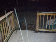
From the album: First snow
-
-
-
 LMAO!!!
 -
166986 10150527997374893 200632219892 8587857 1767364303 N
Baroclinic Zone commented on Isopycnic's gallery image in Members Albums Category
 holy hell
 -
From the album: First snow
-
After that accident he'll be Robo Miser
-
Love it.
-
December 13th, 2007 rakeage. 12" snowstorm.
-
Remembering Snowpocalypse -- 12/18-12/19, 2009
Baroclinic Zone replied to Ian's topic in Mid Atlantic
This storm did not suck imby. I think I ended up with 19". -
Well historically, he did. 14" and done. This was the storm that broke that camels back.
-
11
-
Weenie radar image from January 12, 2011 @ 3am.
-
Devastating tornado strikes Joplin, Missouri
Baroclinic Zone replied to Hoosier's topic in Weather Forecasting and Discussion
JoMo, I wish you, your family, and your community all my thoughts and prayers. You've been through hell and back.
