Dark Star
-
Posts
1,222 -
Joined
-
Last visited
Content Type
Profiles
Blogs
Forums
American Weather
Media Demo
Store
Gallery
Everything posted by Dark Star
-
13 days out, little faith in the accuracy. Until we actually see true arctic air coming across the pole, nothing will change. I must sound like a broken record, but look at real time data, not the models, to get an idea of what is going on.
-
I know yesterday, the band of -30 was quite small, so I am not hopeful.
-
But WHERE is the cold air coming from? No arctic air in North America. How quickly can the arctic air build and cross over from Norhter Europe to our area?
-

Two Mdt to high impact events NYC subforum; wknd Jan 6-7 Incl OBS, and mid week Jan 9-10 (incl OBS). Total water equiv by 00z/11 general 2", possibly 6" includes snow-ice mainly interior. RVR flood potential increases Jan 10 and beyond. Damaging wind.
Dark Star replied to wdrag's topic in New York City Metro

- 3,610 replies
-
- 1
-

-
- snow
- heavy rain
- (and 5 more)
-
Two Mdt to high impact events NYC subforum; wknd Jan 6-7 Incl OBS, and mid week Jan 9-10 (incl OBS). Total water equiv by 00z/11 general 2", possibly 6" includes snow-ice mainly interior. RVR flood potential increases Jan 10 and beyond. Damaging wind.
Dark Star replied to wdrag's topic in New York City Metro
It seems a lot of newbies don't think you need cold air in the mix?- 3,610 replies
-
- 4
-

-
-

-
- snow
- heavy rain
- (and 5 more)
-

-
Thanks for the map, but didn't a previous long range map in late December show arctic air coming across the pole into eastern Canada? I think we all know the accuracy of these long range models. I admit my skills have greatly eroded, but I have been concentrating more on real time temperatures in Canada. Right now, the core of the coldest air in North America is north of Michigan and just west of Hudson Bay, with a few extensions further west. Then, as you go farther north, it gets warmer. The true arctic air is predominantly over northern Europe right now. So my question is, how or where is the cold air on this projection coming from? What are the inputs of this model and how accurate has it been?
-
and where is the cold air coming from?
-
Where is the arctic air? So far, there is none this side of the north pole.
-
No real arctic air out west. Coldest air is in a wedge north of Michigan, just West of Hudson Bay. There is no continuous feed of arctic air this side of the north pole. You don't need any models to see that. just look at the real time physical data...
-
Two Mdt to high impact events NYC subforum; wknd Jan 6-7 Incl OBS, and mid week Jan 9-10 (incl OBS). Total water equiv by 00z/11 general 2", possibly 6" includes snow-ice mainly interior. RVR flood potential increases Jan 10 and beyond. Damaging wind.
Dark Star replied to wdrag's topic in New York City Metro
Not sure if I ever remember that happening. Models have occasionally shown it, but never really happens? -
Two Mdt to high impact events NYC subforum; wknd Jan 6-7 Incl OBS, and mid week Jan 9-10 (incl OBS). Total water equiv by 00z/11 general 2", possibly 6" includes snow-ice mainly interior. RVR flood potential increases Jan 10 and beyond. Damaging wind.
Dark Star replied to wdrag's topic in New York City Metro
Elevation?- 3,610 replies
-
- 1
-
-
- snow
- heavy rain
- (and 5 more)
-
How so, with no true arctic air in Canada, except for maybe a small wedge of seasonable air along a narrow stretch just west of Hudson Bay? I think if we start looking at the present physical data instead of the models, we might actually see what is happening?
-
GFS Ens looks like it says seasonable in NYC metro area, and warmer the farther north you go, therefore, no sustained cold air?
-
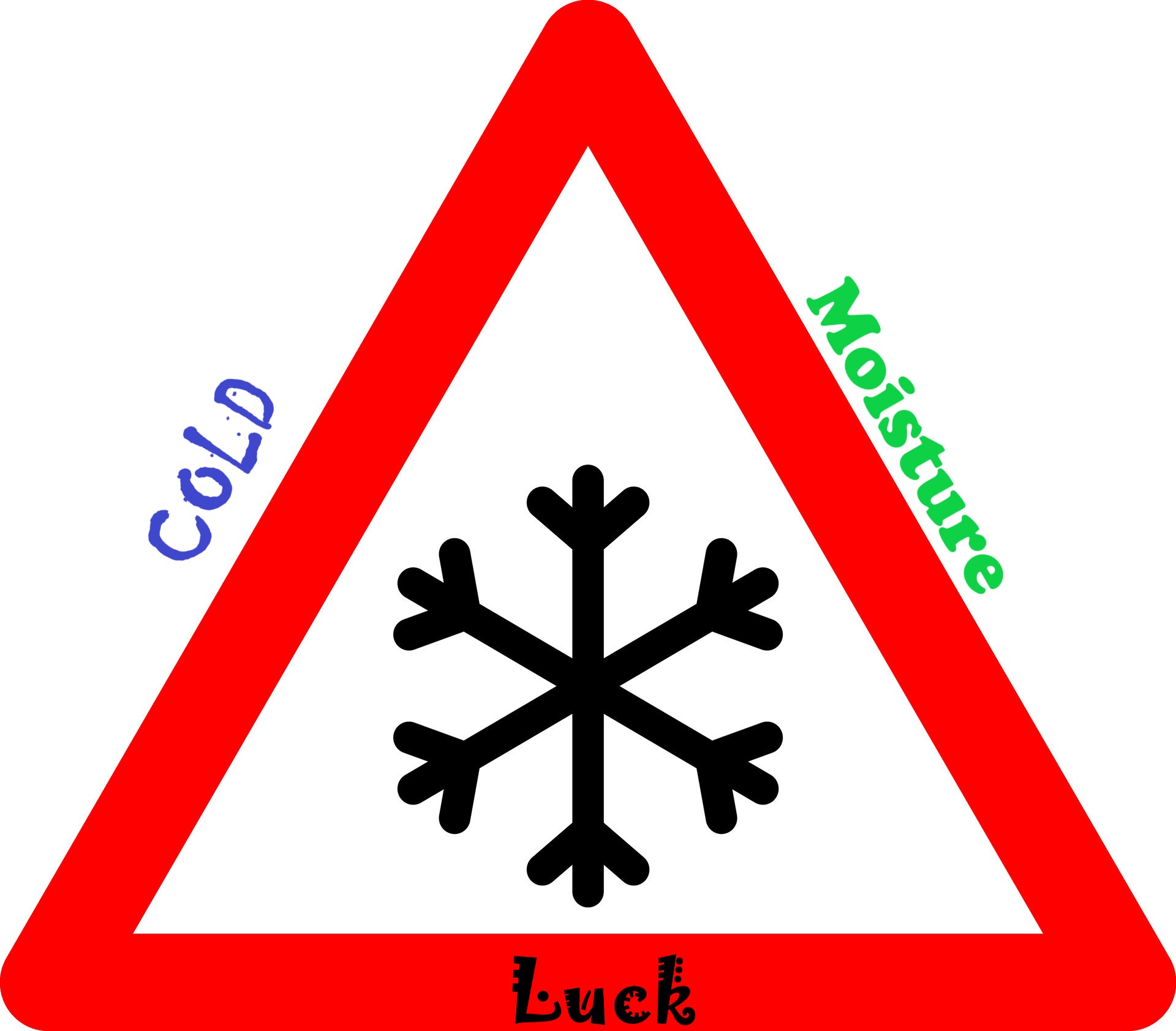
You need cold air. For NYC you need moisture, cold air and luck for snow. We can't have it both ways.

-
But surpressed why? Because of a cold high? That is normally one of the features you need, well placed. Marginal "seasonable" air is not going to cut it, not around here...
-
We could very well be in an unprecedented climate. I lived through the 70's and 80's, and had some mighty cold winters, very little snow. I would put little faith into previous patterns. We haven't seen anything this extreme; including the general warming up of the northeast due to the weakening of the Labrador/Gulf Stream circulation...
-
Extended summer stormlover74 future snow hole banter thread 23
Dark Star replied to BxEngine's topic in New York City Metro
Just for fun, I was trying to locate any "arctic" air in North America. There appeals to be a pool of cold air north of Michigan and just west of Hudson Bay. I don't know if these temperatures are normal for this time of year, ranging from -11 at Churchill and as cold as -36 north and west of there. Then as you travel farther north, it begins to get warmer. So we are cut off from the seepage of any true arctic air. I believe from some of the extended models in December, we should start to see some true arctic air begin to plunge more or less down the eastern side of Canada. Not sure if that is still the case? If not, our area will be marginal at best, at least until February... -
Two Mdt to high impact events NYC subforum; wknd Jan 6-7 Incl OBS, and mid week Jan 9-10 (incl OBS). Total water equiv by 00z/11 general 2", possibly 6" includes snow-ice mainly interior. RVR flood potential increases Jan 10 and beyond. Damaging wind.
Dark Star replied to wdrag's topic in New York City Metro
Or more accurate models? If the models "correct" north and west all the time, isn't it a problem with the models? I wasn't expecting much from the beginning, since the air temperature was marginal, at best...- 3,610 replies
-
- 3
-
-
- snow
- heavy rain
- (and 5 more)
-
Extended summer stormlover74 future snow hole banter thread 23
Dark Star replied to BxEngine's topic in New York City Metro
Can I come? I won't eat much. I promise not to bring my banjo... -
Extended summer stormlover74 future snow hole banter thread 23
Dark Star replied to BxEngine's topic in New York City Metro
Snow in these parts is a miracle, when it occurs. It takes water vapor, cold air, and luck. This coming weekend, we will have moisture, but marginal cold air. I don't remember who posted, but they pointed out that the high pressure in the Atlantic reached all the way down to the Carribean. I never noticed the effect this had on temperatures during a potential snow event, but all information is vital since the models are not that accurate 4-7 days out. My feeling is that with a marginal cold air source, at best, NYC will likely break the "snow drought" streak, but only receive 1-2" of a slushy accumulation before a changeover. However, I defer to the active professional forecasters on this site. A perfect track and intensity could surprise us all.
-
Two Mdt to high impact events NYC subforum; wknd Jan 6-7 Incl OBS, and mid week Jan 9-10 (incl OBS). Total water equiv by 00z/11 general 2", possibly 6" includes snow-ice mainly interior. RVR flood potential increases Jan 10 and beyond. Damaging wind.
Dark Star replied to wdrag's topic in New York City Metro
Then again, if it is going to change to rain, or melt within 24 hours, may as well keep the streak going?- 3,610 replies
-
- 1
-

-
- snow
- heavy rain
- (and 5 more)
-
Two Mdt to high impact events NYC subforum; wknd Jan 6-7 Incl OBS, and mid week Jan 9-10 (incl OBS). Total water equiv by 00z/11 general 2", possibly 6" includes snow-ice mainly interior. RVR flood potential increases Jan 10 and beyond. Damaging wind.
Dark Star replied to wdrag's topic in New York City Metro
I am guilty of coveting your activities...- 3,610 replies
-
- 1
-
-
- snow
- heavy rain
- (and 5 more)
-
Two Mdt to high impact events NYC subforum; wknd Jan 6-7 Incl OBS, and mid week Jan 9-10 (incl OBS). Total water equiv by 00z/11 general 2", possibly 6" includes snow-ice mainly interior. RVR flood potential increases Jan 10 and beyond. Damaging wind.
Dark Star replied to wdrag's topic in New York City Metro
Normally, Union and Middlesex Counties in NJ receive the same type of precip as mid town Manhattan (anticipated debate to follow)...- 3,610 replies
-
- 4
-
-
- snow
- heavy rain
- (and 5 more)
-
Two Mdt to high impact events NYC subforum; wknd Jan 6-7 Incl OBS, and mid week Jan 9-10 (incl OBS). Total water equiv by 00z/11 general 2", possibly 6" includes snow-ice mainly interior. RVR flood potential increases Jan 10 and beyond. Damaging wind.
Dark Star replied to wdrag's topic in New York City Metro
Good point to consider. Despite inaccuracy in all the models 6-7 days out, there are "clues" available that can aid in making a "highly probable" forecast even at this time. However, I defer to the active meteorologists on this site to make those predictions...