

MANDA
-
Posts
1,887 -
Joined
-
Last visited
Content Type
Profiles
Blogs
Forums
American Weather
Media Demo
Store
Gallery
Everything posted by MANDA
-
Only going to take .10" to spoil the record so I hope they measure properly. After this dismal stretch I'd kind of like to make it worth while and break the record.
-
Great article! Looks like 850's reached the holy grail of Arctic cold of -40, and based on that 850 map dropped to -42 / -43 over northern MN. Also, classic surface high pressure stretching from the high Arctic down to the gulf coast. Not to mention the polar vortex and insanely low HTS over the lakes. Just don't seem to make them like this anymore.
-
Record lows from the Regan Inaugural outbreak. Remember it well. Was an intense, widespread and classic outbreak from right over the pole. If memory serves 850's dipped to -38 / -39 along the MN border. I have the old DIFAX maps in a box somewhere in the basement. Amazing outbreak.
-
.10" (one tenth) will push us to second place. You know it will happen just to add insult to injury this winter.
-
Agree with all of this !
-
Yes. Transient cold at best. And I use the term "cold" loosely.
-
These longer range progs are a moving target and have not shown any consistency for months as far a eastern U.S. snow and cold go. As we go through time and get into the 3-5 day range they revert to what we have been seeing since November. Until something sticks and holds for several cycles and gets into at least the 5 day period I'd consider them all dubious.
-
Unless 6+ I'd rather shoot for the CPK shut out. Can do without the nickle and dime stuff that is gone in a day or two. Just my opinion and I realize I am probably in the minority.
-
Wash. Rinse. Repeat. Until something changes nothing will change.
-
Real nice look from the EPS Mean. Now the trick is to get it to stick as we move to days 7, 5 and 3. Up until now we've not been able to hold a decent look for more than 2-3 cycles. If we can have the EPS mean look like this or something similar on the 12Z cycle this Sunday or Monday I might start to get more interested. No doubt this looks good but we need to get it to hold.
-
I thought the same thing. I got down to zero during the Christmas Outbreak. Seems odd but the Arctic push was south and then east. In addition to that lots of above normal heights all month to our north. Just look at the positive temperature departures over New England for December. Just very odd though that I was 10 degrees colder than Montreal for the season so far. Heck, even NYC got below 10 this season. Wonder when the last time was that NYC had a colder minimum temperature than Montreal season to date.
-
Don- You are the "STAT MASTER". Great stuff as always.
-
A solid 6 days away but at least something to watch with some interest. Just not much else to hang our collective hats on these days. Odds low especially along and southeast of I95 especially outside of New England. Something to at least have some interest in.
-
Just a trace of snowfall here....BARELY. Jut the slightest coating on the deck and snowboard only. Was not not expecting much so not much disappointment.
-
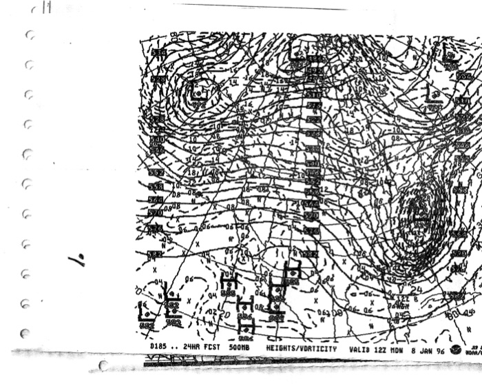
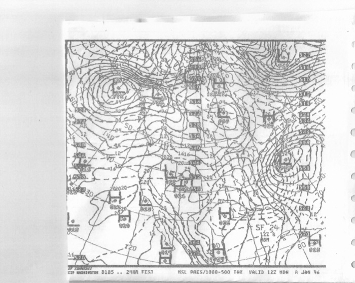
some additional maps
-
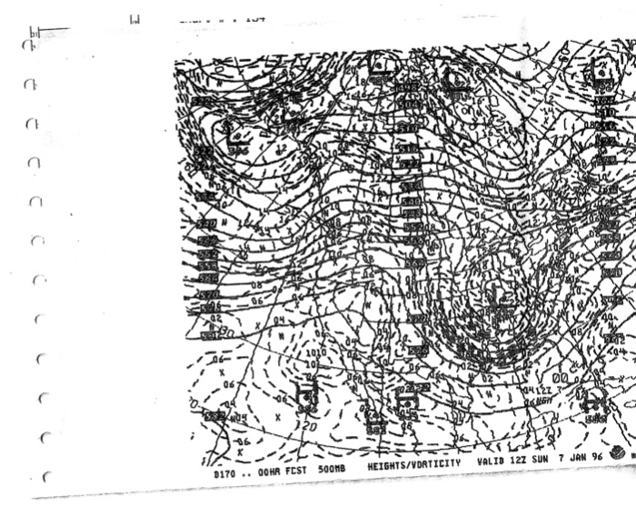
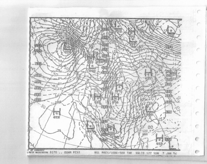
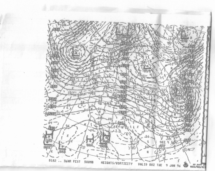
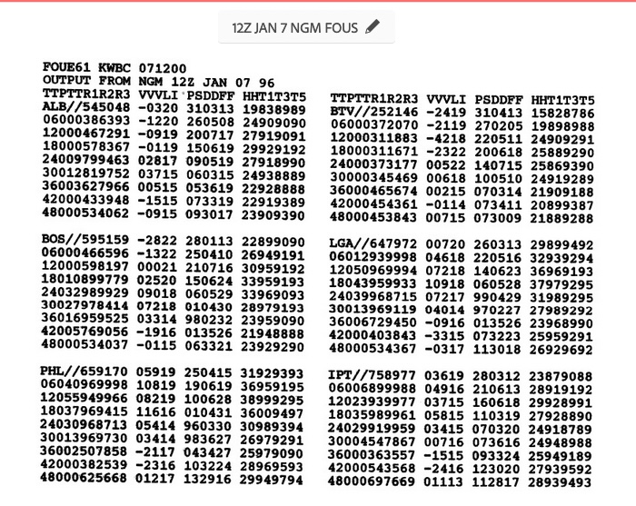
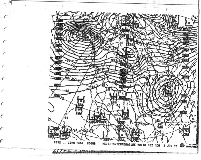
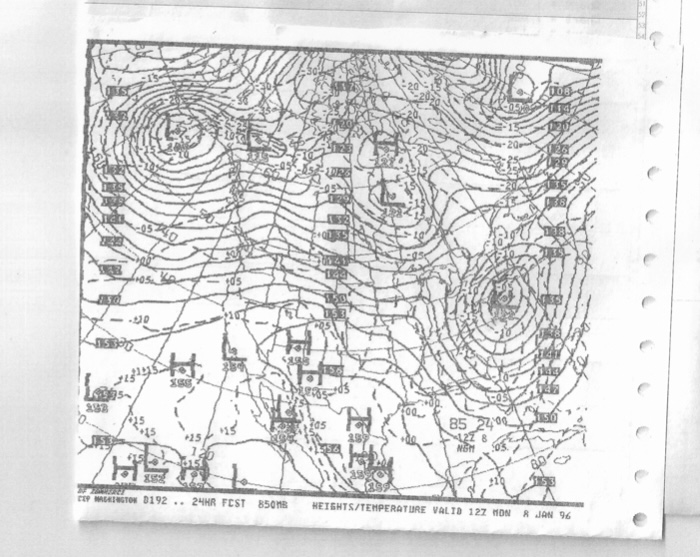
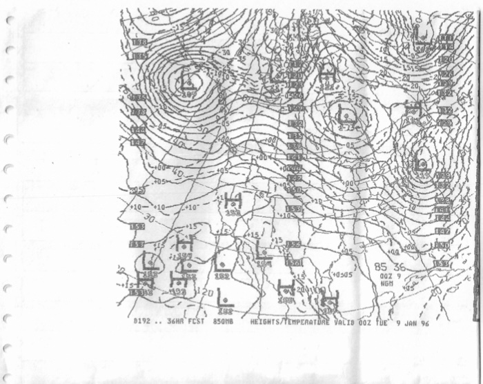
Might not be exactly the forum to post this but since there is not much else going on I'll go for it. Where were you on this night 27 years ago? Time has flown but that storm ranks up there as one of my top 5 favorite snowstorms for many reasons. Not the least of which is that I got to forecast for it and it was the experience of a lifetime. Was working the 5am to noon shift at Ion Weather that weekend which was then located in the base of the tower at KMMU. Thanks to Steve P. for giving me one of my first broadcasting opportunities. Was doing radio for some smaller radio stations from Hagerstown, MD across to Bucks and Montgomery Counties in PA. numerous stations across NJ from ACY area up to Sussex County and across into the Lower Hudson Valley. Was quite the busy Sunday morning 1/7/96. Conditions deteriorated over the course of the morning and by the time I left just after noontime you could barely see across the field to the runways. Visibility was about 1/8 to 1/4 miles with S+ and BS. The usual 20 minute drive home took 60 minutes and was a white knuckle trip. Thankfully traffic was very light. Still have the forecasts that I prepared that morning. Anyway, I saved some of the DIFAX maps from that Sunday morning. Weather / maps on the internet was just coming into its own and nowhere near the caliber of maps and models we have today. The maps are old and I had to shrink them to scan them but if you can zoom in they are just classic. The 850 low track was text book. Surface low literally crawled up the coast. Classic banana high banked to the north. Check out the VV on the FOUS data with associated QPF.
-
Just preparing a post about that with some old DIFAX maps.
-
EURO = Wash. Rinse. Repeat. Persistence is a forecasting tool. I'm quite sure the evolution of things will not be exactly as EURO depicts. Entire week away and there will be changes. Not saying for the better necessarily. EURO as currently modeled certainly meets the definition of persistence.
-
Combined with the fact the we'll be going towards a more +PNA and MJO in more favorable phases and -AO and -EPO (not huge negatives but negatives) based on this and that it is not just the GFS I'd have to say this is the best CHANCE at SOMETHING so far this season. Just have to see if trends hold. We're quite a ways away and nothing in this time frame has held so far this season so there is reason for caution. At least something of interest. Better than continuous torching.
-
That ENS M looks pretty textbook. Remains to be seen if that solution comes close to reality. Will be interesting to watch future cycles to see if something at least close to this holds. It sure looks like something with potential to produce but keeping expectations in check. At this point I'd say worth watching but not more than that.
-
First 70 degree readings of the year showing up. Just balmy out.
-
Just shows you how little weather of interest is currently going on or is expected to go on in the near future if you like cold and snow.
-
Great job Don as always. So, December to finish .70 below normal against the warmest normals we've had. Majority of this forum had no snow or nothing meaningful. I had 4" at my location from 2 events. I was close to the southern edge of things with 1" or less totals just a 30-minute drive away. Were it not for the 4 days of intense cold we would have been above normal. This from a month that many were expecting so much from. Especially the second half. We basically had a 4-day cold snap. Was a wet month (and year) at my location with 6.44" for the month and just over 52" for the year. Just was not well distributed during the summer months. I see from the latest Drought Monitor the south shore of Suffolk County is still in Moderate Drought. Hope January can deliver something better, but my expectations are low.
-
Yep, and it is not going to buckle easily. Going to be a while. Terrible pattern, no way to sugar coat it.
-

December 22nd - 23rd Cutter Discussion and Observations
MANDA replied to NJwx85's topic in New York City Metro
Overnight low of -0.4. Officially zero. Was 56 at 5am Friday and -0.2 at 5am this morning for a 56-degree 24-hour temperature drop. Merry Christmas to all.

