

MANDA
-
Posts
1,887 -
Joined
-
Last visited
Content Type
Profiles
Blogs
Forums
American Weather
Media Demo
Store
Gallery
Everything posted by MANDA
-
Per visible satellite think blob over all of western / central NY and sinking south. Nasty.
-
On another note: Still a decent signal for some needed rainfall early next week. I think this will be best chance in a while for some widespread .50" to 1" amounts. Perhaps locally more but not going to jump the gun.
-
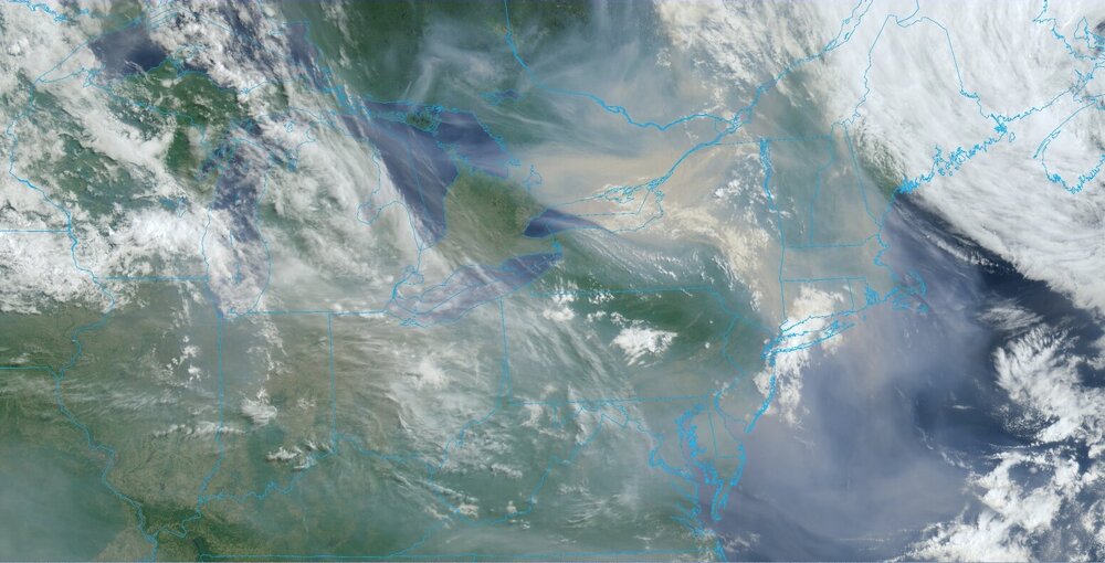
Lots of smoke over a large area of the Northeast this morning.
-
Somewhat notable signal for perhaps some needed rainfall in about a week from the 12Z guidance. CMC not as robust as EURO/GFS. Looks like another complex upper low evolution early next week from the Great Lakes to the eventually the Northeast. Pattern might have some teeth so worth watching as the week progresses. Until then just some hit or miss showers / T-Showers tomorrow and Thursday. If you get rained on either day consider yourself lucky. Tomorrow better chances over Thursday. By the end of the GFS run ridge building over the Southern Plains with HOT conditions developing over the south central U.S. Widespread 90's and 100+ once past mid month that area. Time will tell if it makes a push north and east near the end of June or so. That potentially evolving pattern may help to enhance rainfall chances around here for second half of June. Rest of the week will feature near to below normal temperatures as upper low over/off New England dominates flow pattern over the Northeast. Not a fan of intense heat so I'll take it. I'll also take some rain.
-
Smoke plumes. Still significant smoke plume backing westward with upper flow through the central and eastern Great Lakes from Central/Western Canada fires coming southward on eastern side of upper ridge. As someone here mentioned yesterday (forgot who) numerous fires and plumes over eastern Canada showing up well on latest visible loop. Heading for another week without precipitation around here. http://www.meteo.psu.edu/ewall/PSUGOES_NE/loop60v.html
-
Not a drop of rain here. Thankful for a cloudy cooler day today!
-
Yes and rather quickly over the last week. Upcoming pattern does not look favorable for anything more than localized showery type stuff. As the guy who likes hoodies said the reservoir levels are good but if this pattern does not break they will start to decline. I just don't see any sign of a shift to a wetter pattern. At least not for the next 2-3 weeks.
-
No change to the current Drought Monitor week over week for our area. That seems destined to change with next issuance on 6/8. Large expansion of Abnormally Dry across PA into the southern tier of NYS. Not overly optimistic for any meaningful rain over the next 7 days. Looks to be generally in the .25 - .50" range.
-
The below normal months are barely below and the above normal months are well above.
-
Very solid signal from 12Z guidance for a first class soaking for Northeast New England next week. Especially eastern MA into NH and ME. Final details to be worked out on how it evolves but setting up for a good soaking over that part of the Northeast. Elsewhere not so much. Could be highly anomalous upper air and surface evolution.
-
It was mostly from 4/30. I report to CoCoRaHS so I was using my CoCoRaHS report for 5/1 (7am 4/30 to 7am 5/1) for the 1.96". No matter how you slice it like you said the ground (especially top soil) is parched and not likely to get better over the next week or so at least.
-
Rainfall here 2.85" for May. Majority of that fell on 5/1 with 1.96". First 7 days 2.31". Between 5/7 and today only .54". Last 3 weeks have been very dry. Non watered lawns in full or even part sun drying / browning very quickly. Watering flowers and garden almost daily. Lawn might become a losing battle if this keeps up much longer. I don't want to waste water + it gets expensive.
-
Still a remarkable lack of rainfall over the next 7 to 10 days on most of the latest guidance. Lawns in partial to full sun in my area that are not being watered are browning QUICKLY. Planted flowers and vegetables being watered every second to third day. Potted plants needing water daily or they wilt.
-
Pattern next 2-3 weeks looks dry with temperatures averaging near normal. Trof axis in the mean looks to center near or just off the northeast coast. That would favor a dry and warm NW flow. Readings of 90+ look to be very limited through at least June 15th. Would not expect more than 1-3 days of 90+ at CP over the next 15-20 days. This dry pattern is not going away anytime soon and it stinks. The hose and the sprinkler system are my new best friends.
-
Just nasty if you are gardener or have ag interests.
-
I saw that but didn't want to go there. Kind of far out there but we need the overall pattern to break so it might be correct! Until we get the persistent above normal heights away from the northeast and adjacent parts of Canada and the Atlantic I don't see potential for change to a more frequent wetter pattern. At this point I'd welcome some south or southwest return flow to pump up the moisture for a front to act upon. Just looks like a rather dry and turning warmer west to northwest flow aloft.
-
Nice clean and smoke free air mass for a change. All the smoke has been pushed south and WAY south at that into parts of the gulf coast states. Unfortunately with the continued lack of rain the bright sun will continue to dry the top soil. As SACRUS suggested no meaningful rain prior to 6/2 or 6/3. Whole lot of drying between now and then. Will be watering frequently.
-

WPAC, Indian Ocean, and Southern Hemisphere Tropical Cyclones
MANDA replied to 1900hurricane's topic in Tropical Headquarters
Guam got very lucky at the last minute. We'll see how many of these monsters are generated this season with the strengthening Nino. -
Had .03" rainfall last evening. Meaningless.
-
At least in my opinion I find these extended dry periods beyond annoying. Pattern has been repeating for a while now. Next 10 days look generally dry and with 10 day dry stretches it does not take long for the soil to dry. Only saving grace lately has been "cooler" weather and persistent haze with some clouds. You get a 10 day dry stretch with bright sun and temperatures in the m/u 80's + and grass and gardens left without irrigation will crisp quickly.
-
Yep, back to the dry pattern. Feel bad for the folks that did benefit in a meaningful way from the rain this past weekend. Back to watering the garden and the lawn. Thankfully temperatures are being held in check for now, no complaints in that department from me. I'll take this over 90+ any day.
-
Nasty smoke plume persists over the northern plains stretching across the GL into parts of the NE. Those Canadian fires have been going on for about 3 weeks now I think. Smoke advisories and air quality alerts across parts of MT.
-
Had .48" rainfall here. Double what I was expecting. I'll take it. Once to the Delaware River amounts dropped off to near nothing. The wetter models over NJ were very overdone and the drier models were underdone. Long Island into SNE did the best which is what nearly all the guidance had.
-
Just some light rain and mist here now. Did have a period of moderate rain a while ago that got me to .28". Radar says anything else will come from the front later. Looks like that will move through rather quickly but additional showers or a period of rain likely. I reached where I expected to be so anything else is gravy on the biscuit.
-
Same here. Still hoping I can crack the .25" mark with some additional showers later on associated with the front.


