HKY_WX
-
Posts
3,113 -
Joined
-
Last visited
Content Type
Profiles
Blogs
Forums
American Weather
Media Demo
Store
Gallery
Everything posted by HKY_WX
-
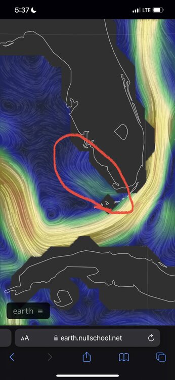
The EWRC came at the worst time yesterday. You could see this coming.
-
Not sure, but I would think any kind of hostile conditions could trigger it. I only brought up dry air bc thats all I see at the current time. I dont see any signs of shear impacting it currently.
-
There's a bit of chicken/egg here though. I read a research paper a few years ago that studied annular hurricanes and how being embedded in a drier surrounding environment can sometimes trigger ewrc's and cause the phenomenon. The model physics take the mid level dry air into account. With the euro showing an intensification period starting on approach tomorrow, I would pay attention. This current reorg is prob already factored into that.
-
Considering an afternoon landfall tomorrow, the timing of this may suck for Florida. Timing wise its prob likely the current ewrc will complete this evening, leading to another period of intensifying before landfall.
-
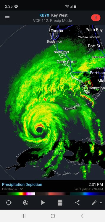
Thats a hell of a northern eyewall forming
-
If you look at the Hires images, the EURO strengthens Ian all the way till landfall at Charlotte Harbor. Devastating run for them. It's a whole different ball game now that the trough has caught Ian and is pulling it NE. This may act to encourage strengthening all the way till landfall with the additional aid to outflow ventilation. As opposed to meandering storm in the cooler waters near the big bend (further north).
-
Agreed. We went from possibly a weak Cane meandering North offshore to a potential Cat 3+ hitting central Florida at a decent clip. That said, this will be costly as that's such a populated area of the country.
-
Yeah, I'm not sure I buy that unless we see king euro jump on that train. If the Hurricane models/NAM are right, it would be a solid 2nd hit in GA/SC.
-
Just taking a look at forward motion and trends, I'm starting to lean south as well. No time to breath a sigh of relief in Tampa, but trends are going in the right direction for them.
-
I think we're about to see Ian's Wind/Pressure respond in a big way. Vis Sat is spectacular. Central Florida is going to get rocked now that it looks like it's not going to stall offshore.
-
Def appears to be ever so slightly east of due north now. Just taking a tour of the models, some show it bending/almost being sucked inland and others bounce it around the coastline for a while. Going to be a tough landfall to pinpoint. If I had to guess I would go with Bradenton on a NNE heading.
-
150m shift on the euro inside 3 days is dramatic in my book. It could obviously shift again.
-
Literally went from the big bend to South of Tampa in 2 runs
-
Thats a pretty dramatic shift this late in the game.
-
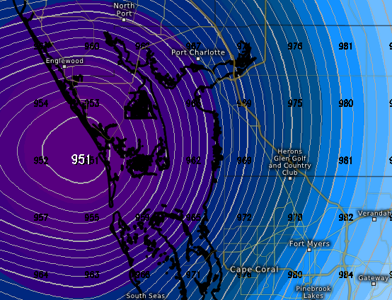
Starting to think forward speed will determine if it makes landfall near TB or drifts further north towards the big bend as a weaker cane. If it's a little quicker/stronger it will likely feel the influence of the departing trough a bit more and keep enough forward speed to make landfall on a NNE/NE track (Likely TB area or south). If it slows down it will likely bounce around offshore for a while and eventually drift north into the Big Bend area until it's re-accelerated by the 2nd trough/westerlies. IMO this is probably Tampa Bay and south... or bust (at least in the Public/Media's eye).
-
Models have shifted towards a more tug from the trough NE once its in the GOM.
-
Ian has a large circulation which sometimes take longer to wrap up. This could be a decent sized windfield once it gets going. I would go with the Euro for track (for obvious reasons). This will be a very costly track if most of western FL (TB and south) is in the eastern flank.
-
Back in my single days I would compare this to waiting on that girl to text you back. You knew in the back of your head it wasn't gonna happen but you held out hope just the same. (I'm sure this is something my fellow weather nerds can commiserate with)
-

Potential 1/28-1/30 2022 winter storm
HKY_WX replied to Prismshine Productions's topic in Southeastern States
Being from Hickory I always wondered what went on at meat camp. Then I drove through one time and realized absolutely nothing goes on at meat camp. -
Potential 1/28-1/30 2022 winter storm
HKY_WX replied to Prismshine Productions's topic in Southeastern States
One thing to watch this evening is as the upper low begins to form and take shape off of the NC coastline is a nice deformation axis likely 100 -150nm to the west of the 850mb low. This is where there could be some banding/enhancement. If this were to occur a bit earlier or more dramatically than forecasted (aka phasing), obviously that would impact totals in a positive way (most likely area that would benefit is eastern NC and SE VA)... Something to keep in mind. Otherwise I will go with the below: HKY:T-1 inches CLT: 1-2 inches GSO: 1-3 inches RDU: 1-2 inches ORF: 2-4 inches -
Potential 1/28-1/30 2022 winter storm
HKY_WX replied to Prismshine Productions's topic in Southeastern States
I think what we're seeing is the mods having difficulty handling the last minute phase possibility. The NAM actually trended better this run for that. IMO there will likely be a band setting up over central NC tomorrow night/Sat Morn that will pivot east. The strength of the band will be totally dependent on how much phasing we see at the last minute. More phasing and this band could drop 6+. Less phasing and it's just some snow squalls. -
Potential 1/28-1/30 2022 winter storm
HKY_WX replied to Prismshine Productions's topic in Southeastern States
He's just comparing the Water Vapor Satellite with the NAM's 500mb chart. You can sometimes spot where the models are off. I've often noticed in the winter (specifically +PNA patterns) they tend to be bad at positioning northern stream impulses coming out of the northern territories of Canada. If anyone remembers the Christmas 2010 storm, they totally blew the northern stream shortwave which is why that trended towards a major storm literally the night before. Not saying that's the case here as the models have made huge strides since then. He also has a dog in the fight so take satellite hallucinations with a grain of salt. -
Potential 1/28-1/30 2022 winter storm
HKY_WX replied to Prismshine Productions's topic in Southeastern States
The trend is beneficial to more phasing ultimately. -
Potential 1/28-1/30 2022 winter storm
HKY_WX replied to Prismshine Productions's topic in Southeastern States
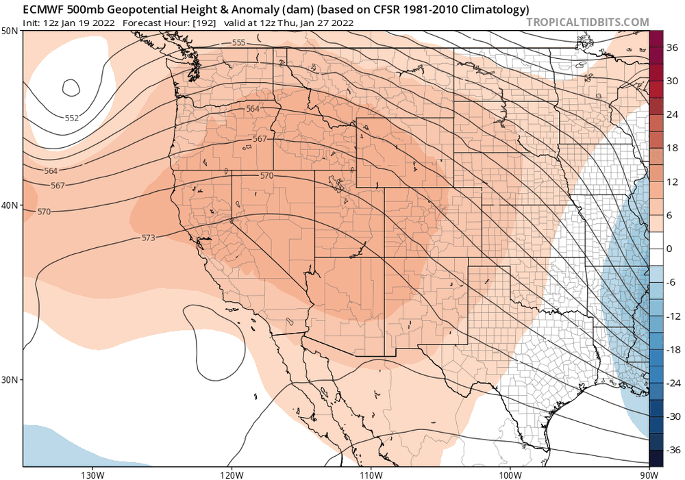
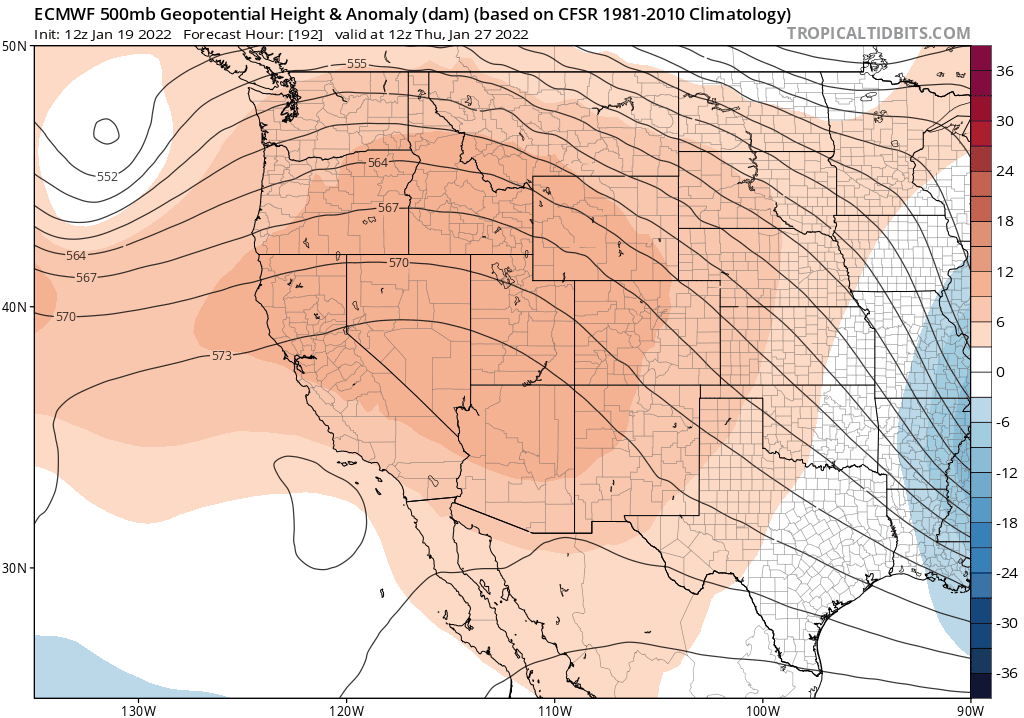
Euro continues to trend the ridge out west stronger. This is what's allowing the PJ to dig/dive a bit further southwest and capture some of the southern energy. Interesting trend to watch.