HKY_WX
-
Posts
3,113 -
Joined
-
Last visited
Content Type
Profiles
Blogs
Forums
American Weather
Media Demo
Store
Gallery
Everything posted by HKY_WX
-
 This will be an impressive storm for Arkansas.
 -
I agree, if you look at the likely SLP track. the above makes the most sense to me. Just fits climatology. There's reason GSP has WSWs and RDU is showing 1 to 2 inches (they are historical pretty conservative). This isn't a major storm but if we manage to screw up and not get a few inches out of it we are truly cursed.
-
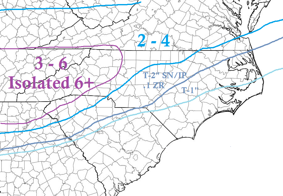
NC-IMBY post. The models continue to key in on a band setting up over i85. Whoever find themselves in that band will likely be where the highest totals fall in NC. Outside of the southwest mountains, the RDPS has consistently shown the highest total along i77 from Statesville to Huntersville (roughly 5 inches).
-
Weenie phase 1 is about commence tonight.
-
We gotta ton of needle ice coming up from the ground in our yard. Shows how cold ground temps are right now
-
Again guys, when the GFS and NAM get a clue on the SLP track evolution, you will see a similar scenario as the Euro/RGEM evolve with them. Just a bit juicer QPF. The end result will likely be the EURO with a bit more precip totals. I would say .25 to .5. The only thing I could see screwing up SNOW totals is IP in the eastern edges of the snow growth zones.
-
Confident Weenie forecast prediction. 10PM Tonight: We'll be getting closer to the NAM range. It will trend south with the SLP to match up with the EURO and show solid NC snow hit. The weenies will freak out and start buying sleds. 10PM Thursday: The NAM QPF will start to decrease a bit to come in line with the EURO/GFS. Weenies will then starting drinking again and curse about the snow drought. 10PM Friday: It will start to snow resulting in a general 1 to 3 inches across the area and weenies will be rejoice making snow angels talking about how great the models were.
-
I'll qualify this as IMBY - NC related. Given the wave is shearing out it seems the expectation should be for QPF around .25 to .5. The question then arises as to precip type. One thing to note, is the GFS has continually taken the SLP further NW than the euro, which changes everyone over to zr or rain. It literally takes from Augusta GA to Hatteras vs the Euro which has it near Albany GA and exiting near Charleston SC. Those are large differences. I would note, given the setup and climatology, the Euro would be far more likely scenario. Given the limited precip, thermals will be huge in this situation. It could be the difference between 4 inches of fluff and a 1/4" of sleet. Not saying compromise/middle road isn't possible either.
-
This is honestly the most realistic scenario among the models. I am going with the below:
-
Qpf is what accumulates. Evap cooling is accounted for.
-
Euro tends to be a bit weak on qpf from my experience. This certainly isn't a major system but the vort should be strong enough to spit out. 25 to .5 qpf in nc.
-
We're starved dogs
-
I'm gonna hug that model
-
We bought a house about 5 miles west of Franklinton 6 months ago. Big difference at my new spot vs places like Fuquay or Clayton.
-
I guess when I was a kid my 6"+ in hickory and is now 2" of slop in Raleigh.
-
The euro and gfs, if you just take the general blend, would be a pretty solid hit from southern TN northern MS/AL/GA into NC Mountains/Foothills. Probably 6+ for those avoiding Sleet/ZR.
-
If you look where that SLP track is sitting (that's honestly all you need to pay attention to at this point). If it's in interior SC then sleet/freezing rain is a given. That's pretty far northwest and likely over done a bit if you look at the ensembles and euro. It's a tick east towards the other models which is good news if you like snow.
-
Yeah. It could be a situation where it does transition back to snow at the tail end. But anything within 20 or 30 miles of the sc coastline usually means mixing in the triangle. That said specifics this far out is prob pointless
-
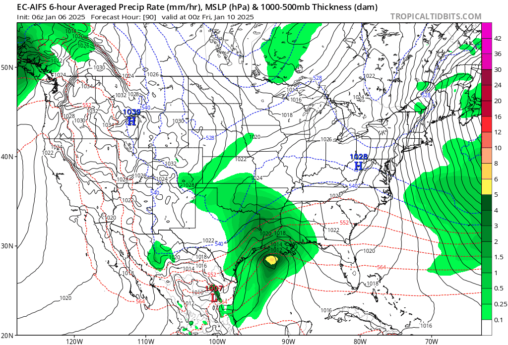
Took a look last night at the model verification scores (Projected SLP vs actual). The best ones in the 3 to 5 day range have consistently been the GFS ENS and EC ENS. Both of those are lined up pretty good. GFS being a little more westward. I like a track from GOM to south of Destin then tracking over southern GA into the Atlantic. From there a track just offshore. Snow wise this favors the northern deep south and western/northern NC area. Central NC would likely be an initial push of snow then over to ice (or rain depending on how far east you are due to the coastal front). With regard to NC only, that would be probably mostly snow in NC Foothills/Mountains over to Winston Salem and then tailing off as you go ENE in NC. The transition line will be somewhere in between. AKA the usual Bullchit.
-
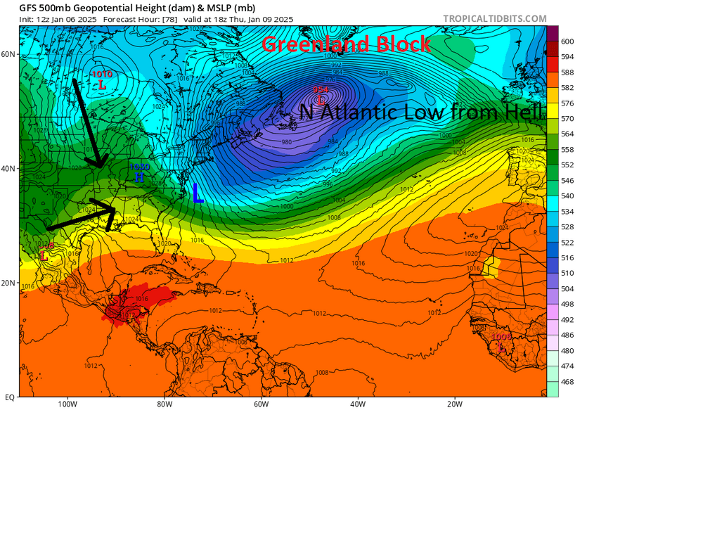
Just from past experience, these runs have the look of a model attempting to resolve a phase or cut off low. I've seen this too many times to ignore. I wouldn't be surprised to see them slowly trend more amped on the backend as the SLP moves towards the Atlantic. It's almost impossible for the models to sort out the various Canadian shortwaves this far out. Given the Atlantic pattern, it's pretty likely this will bomb out, but as far as where remains to be seen. Could be way out into the Atlantic, or it could be off of NC. Doesn't necessarily mean we will benefit from it.
-
As you can see below from this view. The Low over the Atlantic will force everything from Canada underneath it. Which increases the odds of a phase and large cutoff system. Could be great for us or could be not so great if we change to rain.
-
I wouldn't be surprised to see this trend towards a more phased/cut off look given the strong cut off low over the northeast. This really slows down the flow and promotes phasing/cutoffs upstream. We haven't had a setup like this over the Atlantic in many years. The only issue is we don't have a major/classic CAD setup so we will run the risk of a change to rain outside of western NC. That said, the degree of cold air ahead of this system is pretty strong. Will be a fun one to track this week for sure.
-
This is a solid setup for snow and ice in NC. Obviously not a major storm but solid.

-
Euro ensemble mean is about .25 average across NC for Fri/Sat. That is probably the low end in my opinion. This looks like a classic in-situ wedge storm where we start off as a burst of snow and then change to a mixed bag. It could obviously trend a bit stronger or weaker, but for now it looks likely for at least some decent/measurable wintery weather. Beggars cant be choosers after the last few years.
-
32* Here in franklinton. Still got freezing rain for the moment. Drove my son to school and there's nothing once you get down to the wake county line.