HKY_WX
-
Posts
3,113 -
Joined
-
Last visited
Content Type
Profiles
Blogs
Forums
American Weather
Media Demo
Store
Gallery
Everything posted by HKY_WX
-

February 19-20 Major Winter Storm Threat
HKY_WX replied to NorthHillsWx's topic in Southeastern States
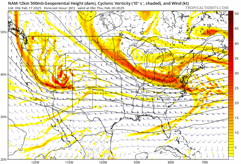
Some of that is due to rates. The Higher resolution 3km can discern individual banding features where higher precip' rates essentially drag down the cold air from aloft. You can actually see bubbles of warmer air above the main 850 0C line on that 3km map above. Also the main mixing is going to come from around 800mb, slightly higher in elevation. My guess is you will need to be north of the Wake county line to totally avoid sleet. Even then it will likely mix in some unless we get some great banding, which could be possible if we can get this to trend a bit more phased like the NAM has been trending. I would love to see this phase a bit more at the tail end to extend this out a few more hours. -
I think im going to move to VAB
-
February 19-20 Major Winter Storm Threat
HKY_WX replied to NorthHillsWx's topic in Southeastern States
Brick, do you just post whatever Snow maps give you more (Kuchera or 10:1 ) lol -
February 19-20 Major Winter Storm Threat
HKY_WX replied to NorthHillsWx's topic in Southeastern States
It's possible. I think that band will likely be overstated by the models. My guess is it pretty much becomes an extension of the lead band. -
February 19-20 Major Winter Storm Threat
HKY_WX replied to NorthHillsWx's topic in Southeastern States
-
A mesoscale thunderstorm complex in the GOM can throw off the models. In that it can cause convective feedback upstream and lead to a gap in moisture coverage vs reality. Of course the inverse can be possible as well if the models aren't anticipating it. Whereas in overrunning (Isentropic) lift scenarios, once a storm starts up it can cause the models to self correct once they start factoring in downstream moisture advection. When these systems start to form over TX/LA area you often see the models start to self-correct and increase totals in SC/NC/VA.
-
February 19-20 Major Winter Storm Threat
HKY_WX replied to NorthHillsWx's topic in Southeastern States
I'll go ahead and say it since i've been thinking it. But if that wave over the plains continues to trend southwest and more amplified, you'll have a scenario where the SLP starts to slow down off of Hatteras and strengthen (basically it's a phase just further south). This will park a deform band somewhere over eastern NC/VA for a longer period of time. The lower resolution models can pick up on this type of stuff more so than the globals. Something the eastern weenies can weenigasm to/watch today and tomorrow on the models.
-
12+ over Tidewater area
-
It's not a great setup for the foothills. It's a combo of this being a west to east type system (Due to the blocky NH pattern) before the Atlantic SLP takes over. So you get a bit of downsloping to start (dry/warm air) and once the column is saturated, the dynamics are shifting east towards the Atlantic SLP. They wont strike out though.
-
I love the warm bubble right over HKY lol. I remember a system in the 2000s where that little valley warm pocket kept us sleet while everyone around was switching to snow.
-
February 19-20 Major Winter Storm Threat
HKY_WX replied to NorthHillsWx's topic in Southeastern States
Prob the same as gso. Maybe a bit more. 2 to 4? -
February 19-20 Major Winter Storm Threat
HKY_WX replied to NorthHillsWx's topic in Southeastern States
My thoughts: AVL to HKY Corridor: T to 2 CLT: 1 to 2 GSO: 2 to 3 RDU: 3 to 5 Rocky Mount to VAB: 4 to 8 (likely more in spots) -
February 19-20 Major Winter Storm Threat
HKY_WX replied to NorthHillsWx's topic in Southeastern States
Don't recall many situations where the 3k and 12k versions of the NAM were so different. The model is clearly struggling with this one. -
February 19-20 Major Winter Storm Threat
HKY_WX replied to NorthHillsWx's topic in Southeastern States
Seems like the repeat of the previous systems is occurring again. Starts heading west around 48 hours out. -
February 19-20 Major Winter Storm Threat
HKY_WX replied to NorthHillsWx's topic in Southeastern States
Something the short-range Canadian and NAM both trended on at 12z was the PJ energy. Both shifted it a bit west which allows the trough axis to be a bit more neutral titled. This allows more moisture back west. This will be key if you want a trend towards a juicer system, instead of another suppressed 1 incher. Interested to see if the Euro reverts back some at 12z toay. -
February 19-20 Major Winter Storm Threat
HKY_WX replied to NorthHillsWx's topic in Southeastern States
I think this one is going to come down to how quickly that trailing PJ energy phases into the trough. At this point I would rather see it trend stronger even if it results in a changeover as i'm more concerned now with it trending to a quick nuisance event for everyone. The -AO/Blocking in Canada has really played havoc with the models, but it's necessary in the end if we want a storm. -
February 19-20 Major Winter Storm Threat
HKY_WX replied to NorthHillsWx's topic in Southeastern States
Winter fatigue lol. I'm ready for severe weather season and warm weather after the next 2 wks -
February 19-20 Major Winter Storm Threat
HKY_WX replied to NorthHillsWx's topic in Southeastern States
Nasty.. This could easily trend back towards the southern triangle
-
February 19-20 Major Winter Storm Threat
HKY_WX replied to NorthHillsWx's topic in Southeastern States
Still a helluva icestorm in the transition zone. Where that sets up is still in trouble. I'm definitely not overly excited being in the snow jackpot 72 hours out. Feels like fools gold for RDU right now lol. -
February 19-20 Major Winter Storm Threat
HKY_WX replied to NorthHillsWx's topic in Southeastern States
If this keeps up, its going to be an central/eastern NC/VA Snowstorm special. Crazy trends the last 24 hours. Models are feeling the push of the blocking in Canada. Prepare for crazy NAM/HRRR runs the next couple nights. Get your whiskey ready.
-
February 19-20 Major Winter Storm Threat
HKY_WX replied to NorthHillsWx's topic in Southeastern States
I've just observed a bias this winter on the GFS specifically where it shears out STJ s/w's too quickly. It will likely be wrong with what it's currently showing. It doesn't make much sense in comparison to the pattern aloft. Eastern areas will see more QPF than western areas just by nature of being closer to the moisture source, but there will also be mixing issues further east. The only way I could see this busting for western NC is if the lead wave does indeed shear out/trend weaker and the main show is associated with the Atlantic low as the PJ re-energizes it. That said, I would need to see the EURO show this and it hasn't up to this point. -
February 19-20 Major Winter Storm Threat
HKY_WX replied to NorthHillsWx's topic in Southeastern States
How quickly we forget lol... This will trend both ways bf Weds. Just enjoy the fact that a juicy system is on the way and frozen precip is likely for many of us.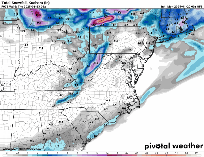
-
February 19-20 Major Winter Storm Threat
HKY_WX replied to NorthHillsWx's topic in Southeastern States
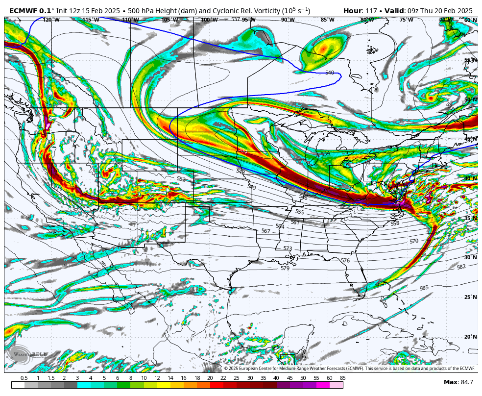
There will likely be an area of enhancement in NE NC/SE VA as the SLP strengthens. This is due to the PJ wave dropping in behind and re-energizing it. We've seen this scenario many times. THe GFS/EURO/GGM are all showing it now. Also the models have clued in on the strength of the blocking and are now shunting this OTS after hitting NC/VA which does make a lot of sense when you look at the broad pattern below: -
February 19-20 Major Winter Storm Threat
HKY_WX replied to NorthHillsWx's topic in Southeastern States
The worries regarding QPF will be short-lived when we get into the short-range. Especially given the consistency of the EURO with totals over 1". TheSTJ wave is amplified and doesn't shear out. It will likely be the opposite as the PJ wave drops in behind it and phases with it. How close to the coast is the million dollar question. Precip type is still the main issue in my mind for NC and where the SN/IP/ZR lines setup. That's still very much in question. As the models resolve the track of the low, the mid-levels (900mb-700mb) will be impacted and dictate that. -
February 19-20 Major Winter Storm Threat
HKY_WX replied to NorthHillsWx's topic in Southeastern States
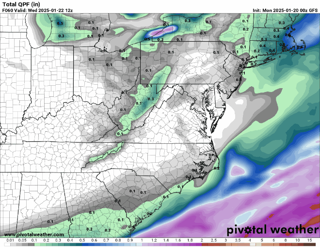
18z Euro with a cool 2' in Richmond. I need that to trend 2 counties southwest lol.