HKY_WX
-
Posts
3,113 -
Joined
-
Last visited
Content Type
Profiles
Blogs
Forums
American Weather
Media Demo
Store
Gallery
Everything posted by HKY_WX
-

-
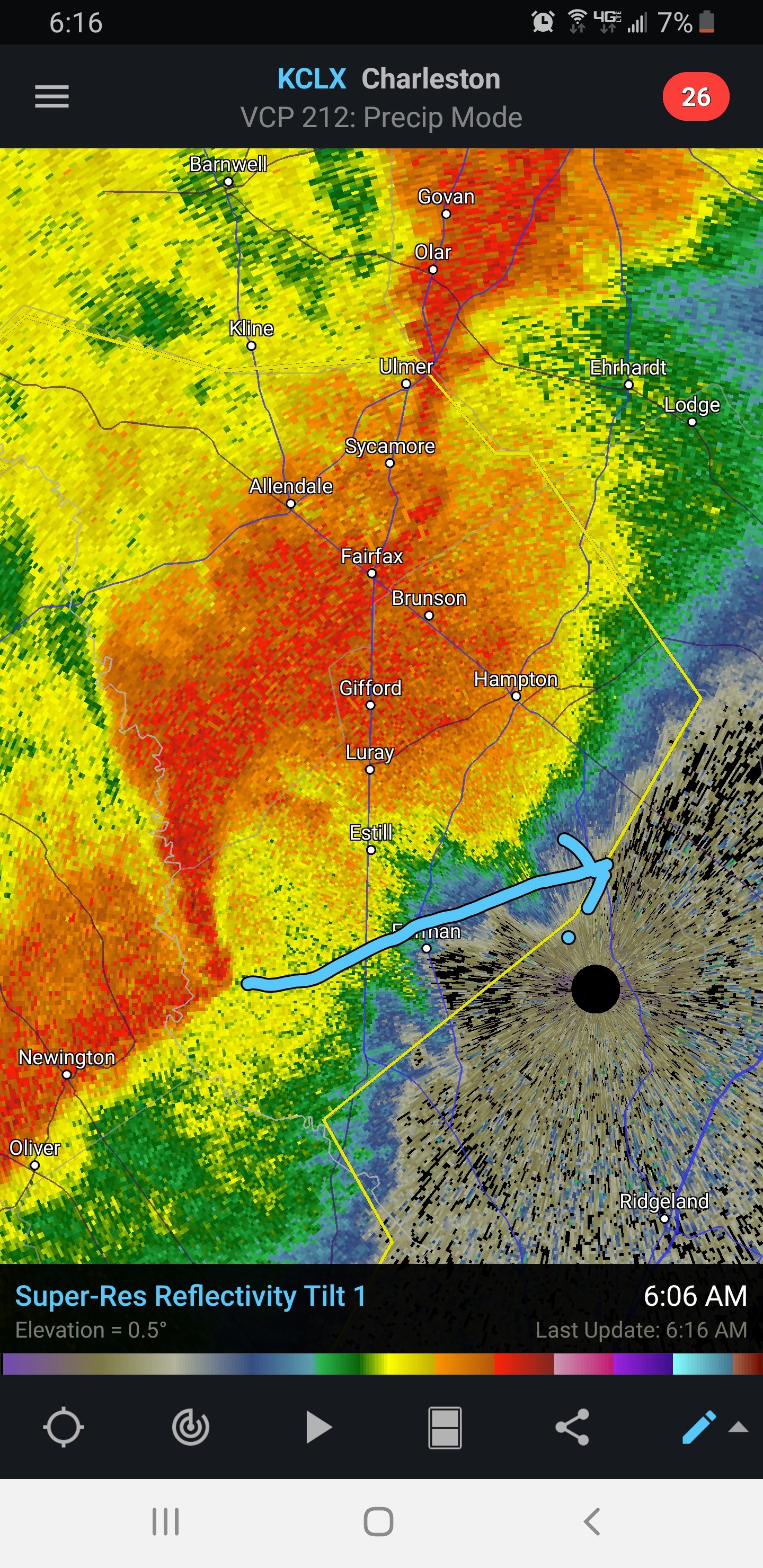
Nasty supercell w debris sig near scotia.
-
Day 6 and 7 00z Euro is interesting from a pattern standpoint. The strong cut off over new England would promote phasing and a low closer to the coast for the trailing PJ wave. Something to monitor.
-
I live close to there. We've had off/on power flashes for the past few hours. Probably got 2.5 inches. Maybe 3. Very very wet snow.
-
Little over 2 inches here in NW Raleigh. Very wet snow. Just took a walk w/ the wife and dog. Fun times.
-
No clue. Don't think I've checked a NWS forecast for 10 years. Don't need to lol.
-
THis is going to be a solid snow in Wake County. It's 33 here in NW Raleigh with moderate snow and it's laying already. This is supposed to keep up till 1am per the mesoscale models. Definitely think 3 to 6 is easily attainable.
-
Solid light to moderate snow in NW Raleigh. Coming down at a good clip now. Starting to get some slushly accumulations on elevated sfcs.
-
That's a ridiculous system day 5-7 on the euro. Huge phase and strong SLP. Could bring more SVR weather to the east coast. Would be a huge snowstorm over the ohio valley. Looks like winter decided to start in Mid February this year.
-
Flurries/Rain/Graupel here in NW Raleigh.
-
Agreed. I think youre sitting pretty for the sweet spot. Some of the meso' models have 8 or 9 inches in that general Greenville area.
-
Seriously... The weather channel?
-
I think RDU is wrong on the later start. IMO the later the better, as it gives more time for the dry air to filter in. There will be some pretty epic temperature drops over central/eastern NC as the column moistens later this afternoon.
-
Thinking 3 to 5 is still a good bet for raleigh. Don't see much yet that would alter the forecast.
-
Nice strong NE breeze here in NW Raleigh and overcast.
-
I do think there will be some banding setting up after 7PM over the eastern piedmont/coastal plain. I'm just not sure if this sets up over Fayetteville or closer to the Rocky Mount/Greenville area. Or potentially further north towards Elizabeth City.
-
I think the only way we get to the RDPS or higher is if we find ourselves in this banding that will setup tonight. It will likely setup east of Raleigh, but if it were to setup over us, that could be a game changers. This is all due to the PJ wave diving in behind, giving some last minute life to the SLP/atlantic fetch.
-
Latest RDU totals via Kuchera Method: 15z HRR = 2.2 12zGFS = 1.8 12zNAM = 3.5 12z RDPS = 5.9 Average = 3.3 inches at RDU
-
The GSO 12z sounding has a nice dry layer at from 700mb down to 950mb. THis will likely result in some quick cooling aloft. I think a transition from rain to sleet/snow won't take long once the higher ratest begin this afternoon. https://www.spc.noaa.gov/exper/soundings/20022012_OBS/
-
I think the one thing that is interesting to note is the HP being configured over the plains generally favors the eastern portion of the state from a CAD perspective. It doesn't funnel the dry air as close to the Apps as well as a banana HP parked over PA. That may be part of the issue for foothills and NW Piedmont from a snow total perspective.
-
Anything's possible. The situation is definitely not ideal for the mountains from a jackpot scenario. That said, given it's mostly overrunning and we're in an el-nino pattern, the models will likely be underdone there. The flow is WSW to ENE.
-
Don't really buy the precip gap over western NC. THe majority of this system will be isentropic lift generated (aka GOM moisture overrunning cold air). The southwest mountains/foothills and NE Georgia generally do well in these setups. There will likely be some back end enhancement over the costal plain w/ some incoming PJ energy Thursday night, but that will be a small enhanced band most likely confined over NE NC. The majority of this will be a front end thump. Radar looks good as well. We are in a weak El-Nino and most systems lately have overperformed QPF wise. Good to keep ground moisture/recent trends in mind.
-
Not really sure I buy the jackpots being so far east given the SLP location. It's not "that" far offshore, given the recent trends. IMO the area from Raleigh to Roanoke Rapids to Eliz' City looks pretty golden in this particular setup. Also over-running tends to sneak up fast and sometimes has a tendency to overperform. So don't be surprised if we see some quick totals add up over the southwest mountains/NE GA tomorrow. I tend to look at the 500mb pattern more so than most, as that's what i've always used for comparison/climo purposes. This one has the look of a classic i40 3 to 6 inch type event to me. Of course lolipops are always possible of 8 to 10. But the overwhelming majority will probably favor lesser totals. Initial sfc temps issues/light rain will likely be overcome by heavy precip relatively quickly north of i40.
-
Looks pretty similar to 18z. Mainly noise. Time for bed. On to tomorrow.
-
Not sure how valid these 10:1 maps are. Will have to dig into some soundings. Not sure I by over an inch of QPF unless we see the GFS/Euro/UKmet jump on board tonight/tomorrow. Overall setup is pretty straightforward. Weak to moderate STJ impulse undercutting the ridge out west. Suppressive PJ flow and strong HP over the plains. It's a pretty classic look for a moderate event (3 to 6 or 4 to 8 type). Area from Ashevilel to Elizabeth City looks Good to me.