HKY_WX
-
Posts
3,246 -
Joined
-
Last visited
Content Type
Profiles
Blogs
Forums
American Weather
Media Demo
Store
Gallery
Everything posted by HKY_WX
-
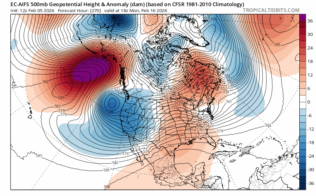
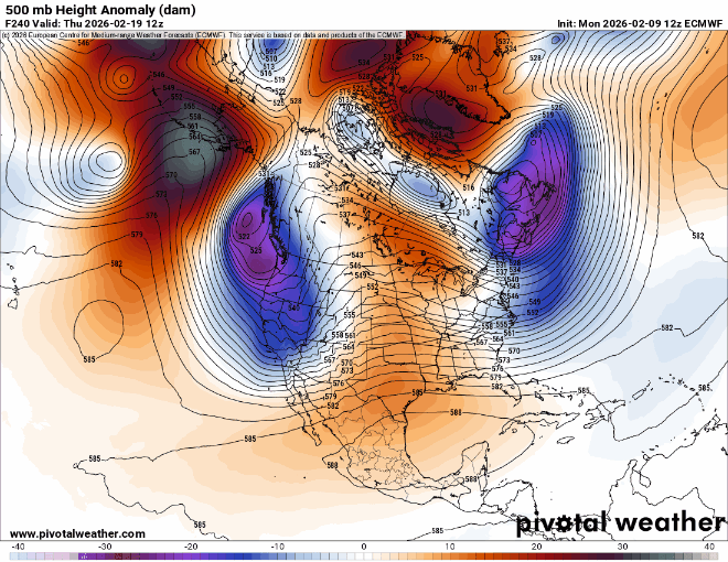
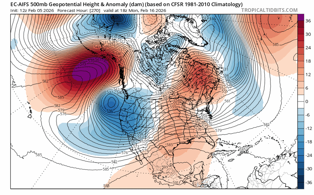
This is a pretty insane -NAO signal day 10. This would displace the mean pattern further south eventually. You would think it could lend itself to one of those classic late winter UL bowling ball snowstorms at some point in late February/March if we're lucky.
-
12 here this Morning and my backyard is still snow covered for the 15th day in a row. Seems like just another day this winter. Pretty wild.
-
The models giveth and the models taketh away... I think there could still be some hope for the last week of February into March. Still early to be calling Winter at this point. That said, I'm going to enjoy the thaw. It's been a fun few months of Winter but my body needs a break. Also i'm tired of trying to entertain a 5 year old indoors.
-
Kinda graupel like
-
Snowing here west of Franklinton
-
AI Euro is showing what i was referring to. Roll over ridges out west normally teleconnect to an eastern US trough. The models this far out are normally pretty worthless, so take with caution.
-
It wasn't that bad up here in central Franklin. We had an 1" back in December, 1.5" sleet, and then 5 inches last weekend. So i guess a total of around 7". Better than the last few winters. We definitely missed out on 2 historic opportunities though. Could have been much better, which is what leaves a bit of a bitter taste on this winter thus far. That said, we still have about 5 (maybe 6) weeks left where we can realistically get something, but the extended modes aren't overly exciting at this point. They have overpredicted the collapse of the -NAO/AO all year though, so I haven't completely given up hope.
-
There are some hints of a roll-over ridge and a return of the +PNA towards the last week of February. Don't see much in the way of winter related action prior to that. Enjoy the thaw next week for now.
-

January 30th- Feb 1st ULL and coastal storm obs
HKY_WX replied to JoshM's topic in Southeastern States
Ended up with 5" here in Franklinton. All fell in a 5 hour period last night. Wild system. Up there with March 1980 for sure. That was probably the best analog 500mb wise, along with Christmas 2010. I feel like my totals did very well outside of Fayetteville. -
January 30th- Feb 1st ULL and coastal storm obs
HKY_WX replied to JoshM's topic in Southeastern States
3.25 here in Franklinton -
January 30th- Feb 1st ULL and coastal storm obs
HKY_WX replied to JoshM's topic in Southeastern States
To my RDU peeps
-
January 30th- Feb 1st ULL and coastal storm obs
HKY_WX replied to JoshM's topic in Southeastern States
We're at 1.5" per hour in these bands around north wake/Franklin county. Recorded that between 7 and 8pm -
January 30th- Feb 1st ULL and coastal storm obs
HKY_WX replied to JoshM's topic in Southeastern States
1.25 in franklintom since 7pm -
January 30th- Feb 1st ULL and coastal storm obs
HKY_WX replied to JoshM's topic in Southeastern States
Heavy snow here in Franlinton. Already have 3/4" in 30 mins. The mega dry air penis has went flacid here in Franklin county -
January 30th- Feb 1st ULL and coastal storm obs
HKY_WX replied to JoshM's topic in Southeastern States
Light snow now here in Franklinton -
The “I bring the mojo” Jan 30-Feb 1 potential winter storm
HKY_WX replied to lilj4425's topic in Southeastern States
-
The “I bring the mojo” Jan 30-Feb 1 potential winter storm
HKY_WX replied to lilj4425's topic in Southeastern States
I'd say 3 to 6 most likely. -
The “I bring the mojo” Jan 30-Feb 1 potential winter storm
HKY_WX replied to lilj4425's topic in Southeastern States
1st & Final Call (Parenthesis is potential; Bigger gap means higher boom/bust potential) Favored Models: Blend of EUROAI & RRFS (Experimental model that will replace NAM this spring) AVL: 3-6 (High:8/Low:2) CLT: 4-8 (High:10/Low:3) FAY: 6-10 (High:12/Low:4) GSO: 3-6 (High:8/Low:2) GSP: 3-6 (High:8/Low:2) GVL: 10-15 (High:20/Low:5) (Likely area to be sweet spot given model trends of last 48 hours. Will get longest duration of coastal banding due to strengthening/consolidating SLP and 850 low) HKY: 3-6 (High:10/Low:3) (Foothills away from the escarpment will have some additional forcing due to upslope. Also lee trough/frontogenesis forcing due to thermal gradient) ILM: 4-8 (High:12/Low:4) RDU: 4-8 (High:12/Low:1) (Area of higher boom/bust potential due to dry air infiltration from parent HP and coastal energy transfer. The Triangle will also be close to the edge of the coastal death band. Bust potential is likely being overdone but I am putting it in as models have shown it) VAB: 4-8 (High:12/Low:2) -
The “I bring the mojo” Jan 30-Feb 1 potential winter storm
HKY_WX replied to lilj4425's topic in Southeastern States
Euro shifted north a bit. Looks better QPF wise for E-central NC. Overall no huge changes. -
The “I bring the mojo” Jan 30-Feb 1 potential winter storm
HKY_WX replied to lilj4425's topic in Southeastern States
Formerly know as the RUC. Aka the original hires gangster. Also the best short-range model during the last minute north trend for the Christmas storm 2010. Which happens to be my primary analog for this system. -
The “I bring the mojo” Jan 30-Feb 1 potential winter storm
HKY_WX replied to lilj4425's topic in Southeastern States
Fayetteville to Greenville looks like a good spot. There will likely be some areas in eastern NC off the coastline that will score huge in this setup as well. The main coastal band has shifted around about as much as I can ever remember on the models this close in. Part of that is the struggle to resolve when this vort rotates negative and just how far W or SW it actually digs. The more it tilts negative, the more Atlantic moisture is drawn in, the better chance for the SLP to consolidate quicker and come closer to the coast. This also moves the 850 low further west and stronger, which increases banding and dendrite growth over the piedmont. My guess is it will be very close to gametime before we know for sure where it will setup. All RDU jokes aside, the Triangle could very well still end up in a banding situation where you get 10 inches plus. Or it could trend south again tomorrow and get 2 or 3. So we'll see. These snow maps this far out are pretty worthless IMO in this situation. It's almost better to just throw out a max/min for the larger cities. I will prob do that tommorow. -
The “I bring the mojo” Jan 30-Feb 1 potential winter storm
HKY_WX replied to lilj4425's topic in Southeastern States
I might actually agree with this. I haven't really seen it oscillate at all, with regards to QPF location. Just up/down with amounts. -
The “I bring the mojo” Jan 30-Feb 1 potential winter storm
HKY_WX replied to lilj4425's topic in Southeastern States
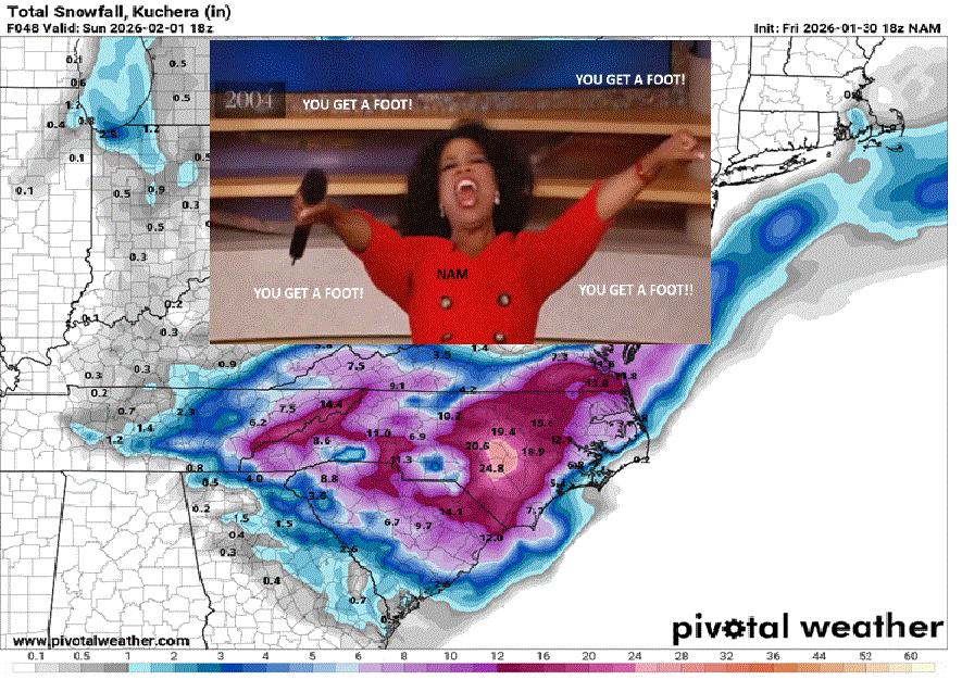
Fixed it
-
The “I bring the mojo” Jan 30-Feb 1 potential winter storm
HKY_WX replied to lilj4425's topic in Southeastern States
Raleigh's the Buffalo Bills of Winterstorms -
The “I bring the mojo” Jan 30-Feb 1 potential winter storm
HKY_WX replied to lilj4425's topic in Southeastern States
Pretty evident there will be some good banding in this system. Great dendrite growth with the cold air and upper low. That's why these areas of lolipops keep moving around. It's virtually impossible for the models to pinpoint them 48 hours out.