
dmcginvt
-
Posts
515 -
Joined
-
Last visited
Content Type
Profiles
Blogs
Forums
American Weather
Media Demo
Store
Gallery
Everything posted by dmcginvt
-
I was in the village today, looked like 6 inches, but that's depth. What fell we may never know. But over 9in fell during this storm with anyone measuring with a board in the village and there's no question about that. I have a foot otg and at least 20 fell. I think ginx won. proximity to the mtn was def a factor, but it's full on winter in Stowe again even in the village I had to go to work today at 782 mtn rd. That .782 miles down the rd. There was def 6 inches otg at 3 pm. After the snow that fell, and then melted and almost disappeared, plus the snow on top of that there's simply now question it was more than 9" .
-
Curious about the MRG vs Bush. Bush may only be going by their cam sites? It was tough with all the wind. Look at that 24 stowe cam. The board gains nothing while the blown in piles up behind it I loved see that. Almost looked like it wanted to buried the thermo
-
I gave up on proper measurement this year because fuck it. Im inconsistent. But we got a ton of snow at 820' and then lost a ton of snow on Sun and then gained a lot back. Right now the only important thing to me is there's a foot in my yard. Yet a lot more fell but it's winter again and i like it.
-
2 inches in an hour an 15, up to 5 I’m
-
right now theres a sharp northern cutoff sugarbush is getting killed, Im less then them and stowe is less than me
-
It's just dumping and I'm at near 4 now. Its heavy and it's wet
-
sugarbush is killing it, nearing 6 in!
-
3 inches now those cat paws added up quickly!! 20 minutes of cat paws
-
At 820' i have 2 inches so far, allyns cam at 4 and it's dumping. Stowe's cam died. Go fix PF nevermind appears to be back now its only at 2
-
I said mush, but it fits
-
I think 18z gfs says mush less snow
-
Its a great afd
-
And this thinking has changed with far less numbers explicitly. heavy precip rates wl help to cool the column just enough to support the wet snowfall. Initial thoughts in terms of snowfall accumulations for first part have changed very little, with a dusting to a slushy inch or two valleys below 1000 feet, 2 to 8 inches midslopes, and 8 to 10 inches summits by midday morning Sunday. It should be noted, adjusting the hrly temp by just a single degree has significantly more or less snowfall acrs our region. Snow ratios wl be low in the 4 to 8 to 1 range, and be highly dependent upon elevation and snowfall rate, given marginal bl temps. The potential for isolated to possibly scattered power outages is increasing for Sat night into Sunday. Tough to tell whats going to happen. I see no doubt there's a good chance of upper elevation snow. Yeah for them! Probably cant fix the best trails but will improve skiing. I think the models still show that upper mtn strong lower mtn rain or meh
-
-
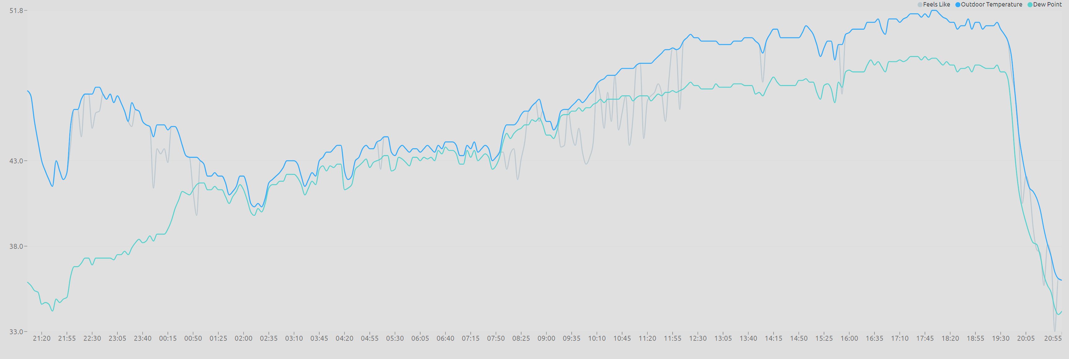
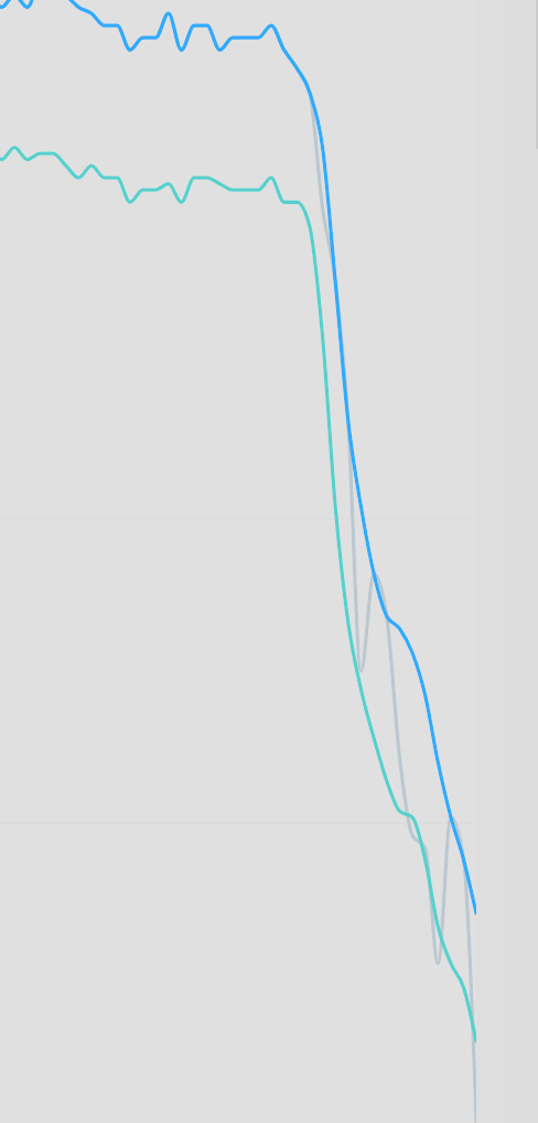
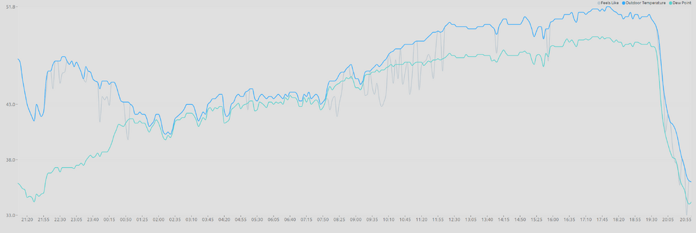
52 to 36 in an hour
-
Wow so sad, we are the same age and I have been in Stowe since 87. Have known hersince. Sadly have only run into her once since the early 90's . She was fucking rad and a joy to watch.
-
Unless one of my servers dies I'm not going to Stowe for ANYTHING for the next 10 days. Getting on rt 100 will be hard enough! I hate this upcoming week.
-
Im curious this next week actually shows some snow in the places that get snow. Do you see it? Or is it no real. "Im high as a kite right now thanks to legal weed. But I think we have some upslope coming
-
that is an amazing penis?
-
As someone that lived in Methuen during the good years of 2000-2003, i feel for Ray. But I have also live in Vermont for most of the years between 87 and now. You want snow you go to the snow. Ray should move to the Sierras. The second he does, the snow will come back to Methuen. And Cali will enter a drought, Then he should very quickly move back to enjoy the snow.
-
It was a Flop... February 2024 Disco. Thread
dmcginvt replied to Prismshine Productions's topic in New England
5 miles to your south, I tread over ice carefully. Nothing melting with the sun . Dog literally walks on snow. He doesnt know what to do, he does his spin to try and clear the snow and doesnt get why it doesnt work because it's so frozen, (iv;e heard this spin move is is also to look for predators) -
There was nothing worse than when they have an explosive shit that goes out of the diaper up their whole back and then dries while they are sleeping. Oh the days I dont miss, literally need a brillo pad to get that shit off
-
from btv afd Would not be surprised based on water vapor presentation of s/w energy and mid/upper lvl trof, this system is stronger than modeled and is slower to shear apart in the fast confluent flow aloft acrs the NE CONUS, resulting in a slight northward trend in pops/precip on Sunday into Monday. At this time, best potential for a snow accumulation would be along and south of Interstate 89 acrs central/southern VT,
-
this warmth going away has as much chance as ntlm going away
-
Boy do I remember that day as my son was born. I was living in Stowe, ex started having contractions at 7 am and I think we finally left for the hospital in Morrisville at noon. What is normally a 10 minute drive turned into 30. It was snowing so hard and was so incredibly windy. Rt 100 was a mess with drifts forming across the road all along the rt. White knuckle the whole way with a woman having contractions. Never knew it was a windex event!