winter_warlock
-
Posts
2,257 -
Joined
-
Last visited
Content Type
Profiles
Blogs
Forums
American Weather
Media Demo
Store
Gallery
Everything posted by winter_warlock
-

Jan Medium/Long Range Disco: Winter is coming
winter_warlock replied to stormtracker's topic in Mid Atlantic
Every decade is different, i dont really go by any 10 year averages. I go by the typical 30 year -
Jan Medium/Long Range Disco: Winter is coming
winter_warlock replied to stormtracker's topic in Mid Atlantic
I personally dont put alot of stock or faith into what any model shows 2 weeks out. Hell models cant even get things right 72 hours out half the time lol. Just gotta wait to see how it evolves.. but any "winters cancelled" claims are just ridiculous in last week of December especially with 3 months left lol... historically In elnino years its usually mid to late january before winter storms really start affecting the east coast and mid Atlantic in earnest anyway! -
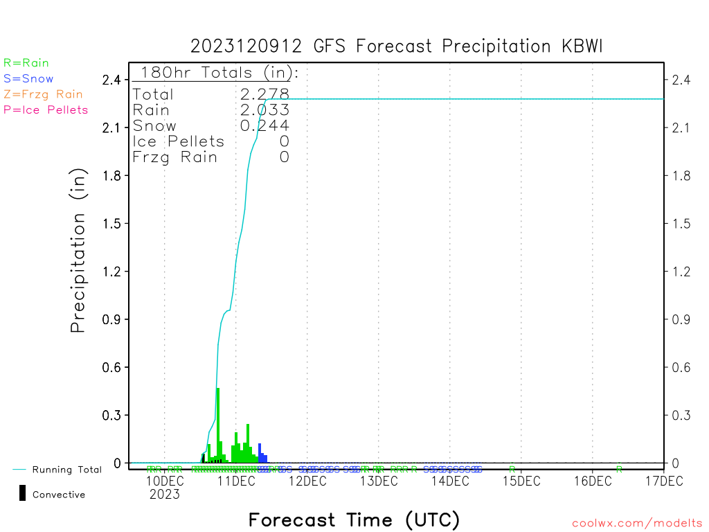
I got 2.15 inches of rain in my guage from this storm! Shame it wasnt snow!! Woulda been a nice 2 footer
-
Wow euro looks almost identical to gfs for this storm!!!
-
Wow enjoy bro!!!
-
Definitely something to watch. Hope it holds as we get closer!!!
-
Hell yesss!!
-
Now thats a thing of Beauty!!!
-
Changed over to snow here in central Maryland after 1.81 inches of rain! Now have moderate snow falling and 34 degrees
-
Heres my typical forecast lol..
-
Intresting.. gfs increased snow on the backend for central MD... hmm hope The trend continues.....

-
Flood Watch Flood Watch National Weather Service Baltimore MD/Washington DC 816 PM EST Fri Dec 8 2023 DCZ001-MDZ006-008-011-013-014-016-504-506>508-VAZ053>055-502-527- 090930- /O.NEW.KLWX.FA.A.0013.231210T1800Z-231211T0600Z/ /00000.0.ER.000000T0000Z.000000T0000Z.000000T0000Z.OO/ District of Columbia-Northern Baltimore-Cecil-Southern Baltimore- Prince Georges-Anne Arundel-Charles-Central and Southeast Montgomery-Central and Southeast Howard-Northwest Harford- Southeast Harford-Fairfax-Arlington/Falls Church/Alexandria- Stafford-Southern Fauquier-Central and Southeast Prince William/Manassas/Manassas Park- Including the cities of South Gate, Manassas, Falls Church, Annapolis, Silver Spring, Chantilly, Bethesda, Arnold, Severna Park, Alexandria, Aberdeen, Reston, Arlington, Gaithersburg, Reisterstown, Franconia, Turnbull, Jarrettsville, Cockeysville, Glen Burnie, Washington, Laurel, Lake Ridge, Suitland-Silver Hill, Herndon, Falmouth, Severn, Dale City, Centreville, Clinton, Columbia, Odenton, Ellicott City, College Park, Annandale, Rockville, Camp Springs, Waldorf, St. Charles, McLean, Montclair, Woodbridge, Greenbelt, Baltimore, Elkton, and Bowie 816 PM EST Fri Dec 8 2023 ...FLOOD WATCH IN EFFECT FROM SUNDAY AFTERNOON THROUGH LATE SUNDAY NIGHT... * WHAT...Flooding caused by excessive rainfall is possible. * WHERE...Portions of DC, including the following , District of Columbia, Maryland, including the following areas, Anne Arundel, Cecil, Central and Southeast Howard, Central and Southeast Montgomery, Charles, Northern Baltimore, Northwest Harford, Prince Georges, Southeast Harford and Southern Baltimore, and northern Virginia, including the following areas, Arlington/Falls Church/Alexandria, Central and Southeast Prince William/Manassas/Manassas Park, Fairfax, Southern Fauquier and Stafford. * WHEN...From Sunday afternoon through late Sunday night. * IMPACTS...Excessive runoff may result in flooding of rivers, creeks, streams, and other low-lying and flood-prone locations. Flooding may occur in poor drainage and urban areas. Storm drains and ditches may become clogged with debris. * ADDITIONAL DETAILS... - Two to three inches of rain are expected Sunday through late Sunday night with the heaviest rains falling during the afternoon and evening. This amount of rain could cause flooding of small streams, creeks and urban areas. - Please visit www.weather.gov/safety/flood for flood safety and preparedness information PRECAUTIONARY/PREPAREDNESS ACTIONS... You should monitor later forecasts and be alert for possible Flood Warnings. Those living in areas prone to flooding should be prepared to take action should flooding develop
-
Love to see that creep just a touch east than were in business !!
-
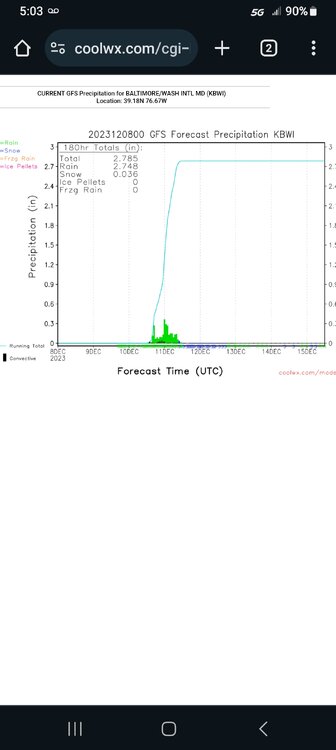
Gfs has me here jn central MD getting tagged with over 2.5 inches of rain!! Gonna be a wet one boys!!! I got my rain guage ready !!
-
Agreed!!!
-
Sterling mentions that!!..... " a fair amount of ensemble members even show it occurring further east. As with many other aspects of the forecast, the finer scale details of the snow forecast remain highly uncertain four days out."
-
Here's how i wish they'd forecast snowstorms!!! Lol!!

-
Lol no it doesn't!!
-
Agreed!!
-
True. Just irked me lol
-
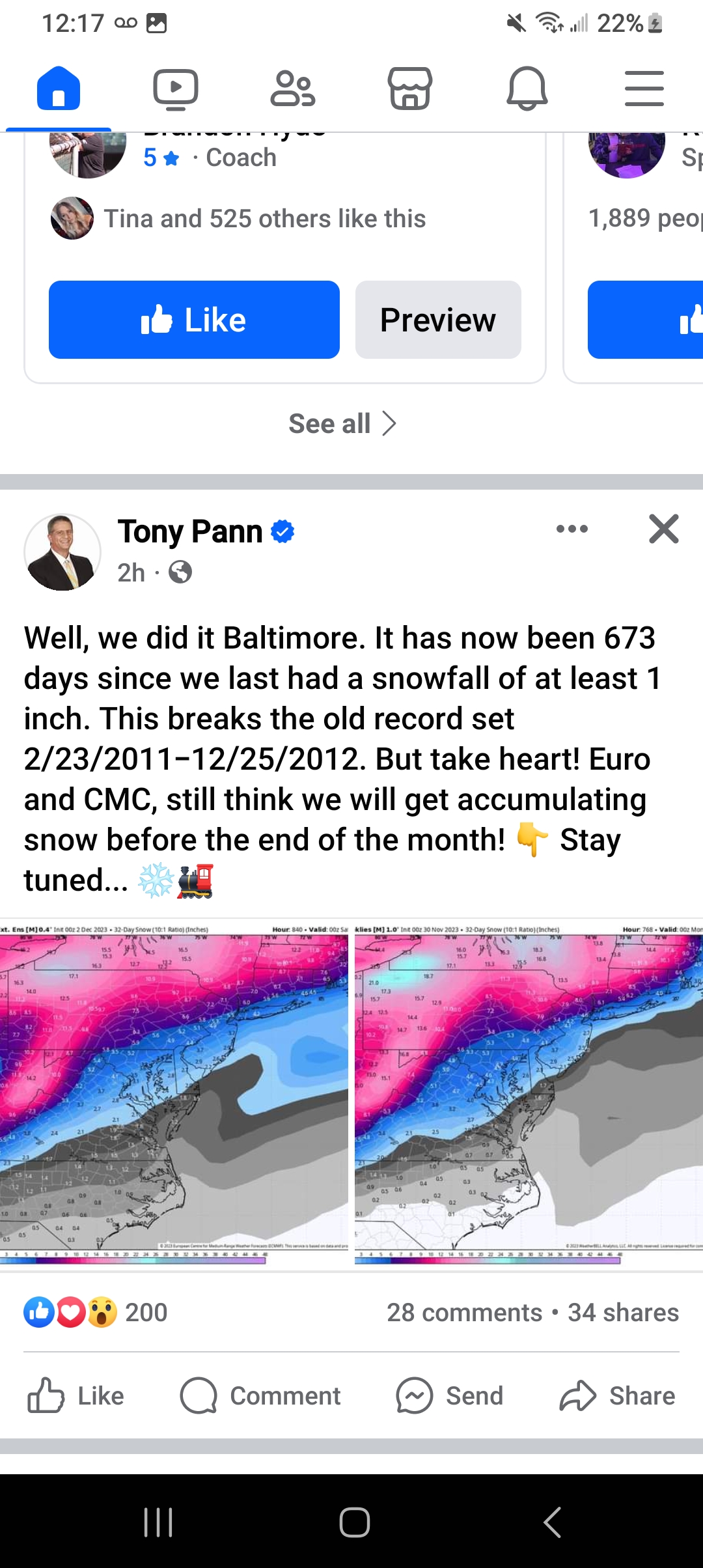
Now this is a rant... Tony pann a met in baltimore. Posted a model on facebook, saying the model is predicting snow by the end of the month. Now anyone who lnows the weather knows that the model will not look like that by the end of the month. So why hype it?? Makes no sense and he loses credibility in my opinion by hyping it!! .. heres the post....

-
Im thinking elnino wont really Make an impact till January.. in my opinion
-
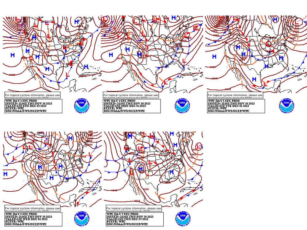
Wpc. Fwiw.....
-
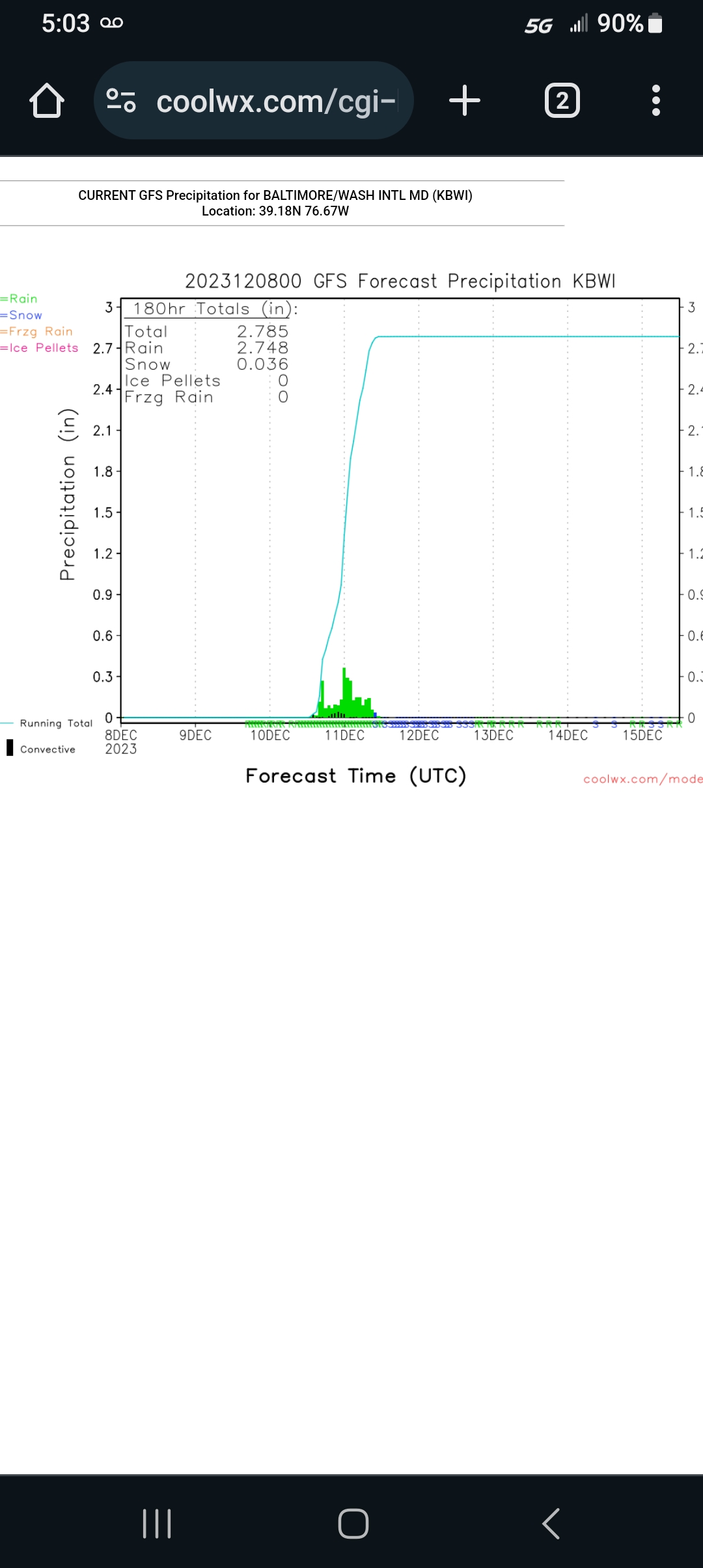
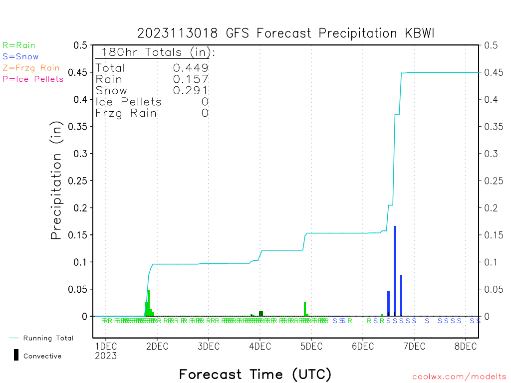
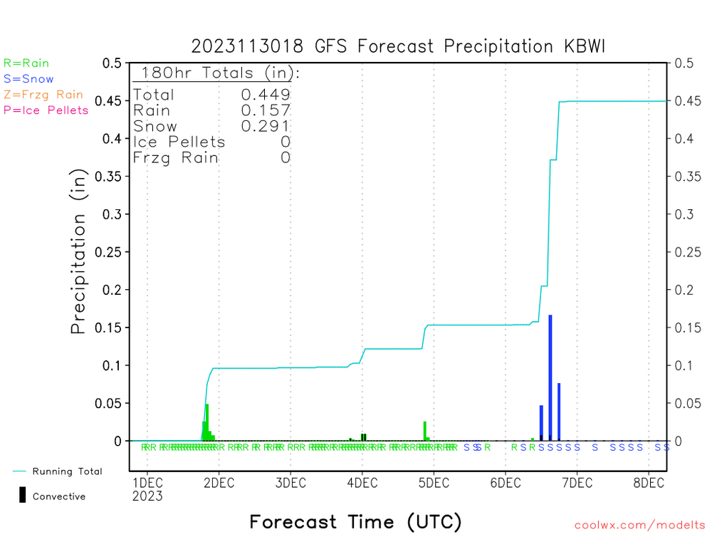
Fwiw..... gfs for central Maryland for the 6th.... and sterling discusses it. They are going to monitor it for now.... trailing trough looks to dive across the Ohio/Tennessee River Valleys Tuesday night, then move offshore of the Mid-Atlantic Wednesday. The placement of this trough, as well as ridging upstream over the Rockies (with an axis through Idaho) and downstream ridging near Greenland would favor unsettled weather locally. However, the favorable ridge/trough/ridge configuration is transient, lasting only 6-12 hours, so things would have to come together just right for a more impactful storm east of the mountains. There may be enough cold air in place for wintry precipitation types, however, so this period will require close monitoring.
-
He has a way with words lol