winter_warlock
-
Posts
2,257 -
Joined
-
Last visited
Content Type
Profiles
Blogs
Forums
American Weather
Media Demo
Store
Gallery
Everything posted by winter_warlock
-

January: Medium/ Long Range: May the Force be with Us....
winter_warlock replied to Weather Will's topic in Mid Atlantic
I know right?? Lmaoo -
January: Medium/ Long Range: May the Force be with Us....
winter_warlock replied to Weather Will's topic in Mid Atlantic
I can live with a tick north! -
January: Medium/ Long Range: May the Force be with Us....
winter_warlock replied to Weather Will's topic in Mid Atlantic
Still over 110 hours away. Models will meander north and south till we get within 48hours. But hell .35 or .40 of liquid could be 6 or 7 inches with 20-1 or 15-1 ratios with temps in low 20s -
January: Medium/ Long Range: May the Force be with Us....
winter_warlock replied to Weather Will's topic in Mid Atlantic
Yesss bring it a touch north!!! -
January: Medium/ Long Range: May the Force be with Us....
winter_warlock replied to Weather Will's topic in Mid Atlantic
Hey neighbor!!! Lol -
January: Medium/ Long Range: May the Force be with Us....
winter_warlock replied to Weather Will's topic in Mid Atlantic
I'm in baltimore county ( north central md) so I'm hoping for a north tick too :) -
January: Medium/ Long Range: May the Force be with Us....
winter_warlock replied to Weather Will's topic in Mid Atlantic
https://forecast.weather.gov/product.php?site=LWX&issuedby=LWX&product=AFD&format=CI&version=1&glossary=1&highlight=off -
January: Medium/ Long Range: May the Force be with Us....
winter_warlock replied to Weather Will's topic in Mid Atlantic
The 14th?? Lol. We got time -
January: Medium/ Long Range: May the Force be with Us....
winter_warlock replied to Weather Will's topic in Mid Atlantic
Sterling confidence growing for a winter storm! Disco from sterling.... "Model guidance and ensembles have been hinting at the potential for a winter storm to impact the region Sunday into Monday of next week. The signal for winter storm has been showing up for a couple of days which is starting to build confidence that some snow could be observed early next week. This potential winter event is associated with the possible phasing of a split upper level flow that may occur near or over our region on Monday. Depending on the track of the system, somewhere in the mid-Atlantic could observe a good amount of snow especially considering the incoming arctic air mass. Confidence in any potential snow should increase as we move into the day 4 to 5 period when we start getting additional Hi-Res guidance coming into range of the event." -
January: Medium/ Long Range: May the Force be with Us....
winter_warlock replied to Weather Will's topic in Mid Atlantic
Saw this on facebook about the coming cold!... fwiw ..... https://www.facebook.com/share/v/VLNGSgNKFkd9xDoX/ -
January: Medium/ Long Range: May the Force be with Us....
winter_warlock replied to Weather Will's topic in Mid Atlantic
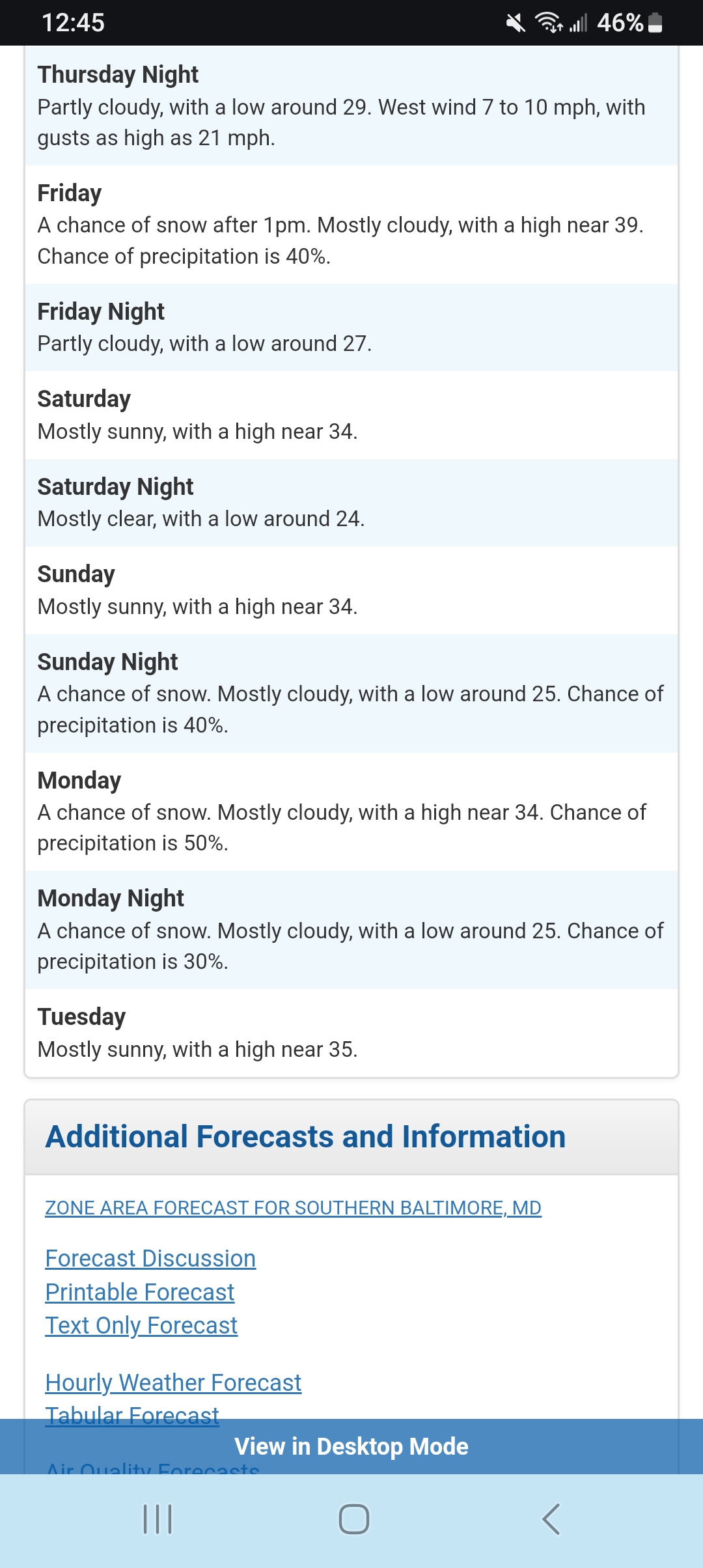
Sterling. Got snow in the forecast for Baltimore county maryland..
-
January: Medium/ Long Range: May the Force be with Us....
winter_warlock replied to Weather Will's topic in Mid Atlantic
Well.. it is new years lol -
January: Medium/ Long Range: May the Force be with Us....
winter_warlock replied to Weather Will's topic in Mid Atlantic
If euro shows something good also I'll have a weathergasm lol -
January: Medium/ Long Range: May the Force be with Us....
winter_warlock replied to Weather Will's topic in Mid Atlantic
Lock it in!!!! -
January: Medium/ Long Range: May the Force be with Us....
winter_warlock replied to Weather Will's topic in Mid Atlantic
All coming together peeps!!! -
January: Medium/ Long Range: May the Force be with Us....
winter_warlock replied to Weather Will's topic in Mid Atlantic
Well there was a time when they were cutting lol -
January: Medium/ Long Range: May the Force be with Us....
winter_warlock replied to Weather Will's topic in Mid Atlantic
True but this time is seems other models are trending toward the euro -
January: Medium/ Long Range: May the Force be with Us....
winter_warlock replied to Weather Will's topic in Mid Atlantic
I'll be up waiting for the euro... curious to see what ukmet says -
January: Medium/ Long Range: May the Force be with Us....
winter_warlock replied to Weather Will's topic in Mid Atlantic
Yep.. the heaviest snow is usually not far from the mix line -
January: Medium/ Long Range: May the Force be with Us....
winter_warlock replied to Weather Will's topic in Mid Atlantic
Definitely better then 18z. In my opinion -
January: Medium/ Long Range: May the Force be with Us....
winter_warlock replied to Weather Will's topic in Mid Atlantic
Im Sure he's lurking lol -
January: Medium/ Long Range: May the Force be with Us....
winter_warlock replied to Weather Will's topic in Mid Atlantic
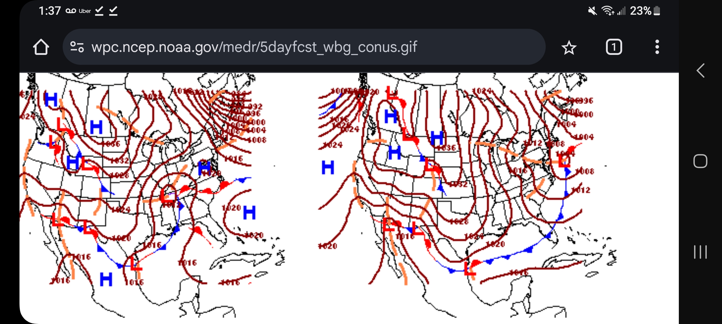
Latest WPC. Places storm just off coast...
-
January: Medium/ Long Range: May the Force be with Us....
winter_warlock replied to Weather Will's topic in Mid Atlantic
Is that a banana high I see????? -
January: Medium/ Long Range: May the Force be with Us....
winter_warlock replied to Weather Will's topic in Mid Atlantic
Music to my ears!! -
January: Medium/ Long Range: May the Force be with Us....
winter_warlock replied to Weather Will's topic in Mid Atlantic
i was thinking that! But didn't wanna jump the gun lol